
Pomerania is a historical region on the southern shore of the Baltic Sea in Central Europe, split between Poland and Germany. The central and eastern part belongs to the West Pomeranian, Pomeranian and Kuyavian-Pomeranian voivodeships of Poland, while the western part belongs to the German states of Mecklenburg-Western Pomerania and Brandenburg.

Mecklenburg-Vorpommern ; also known by its anglicized name Mecklenburg–Western Pomerania, is a state in the north-east of Germany. Of the country's sixteen states, Mecklenburg-Vorpommern ranks 14th in population; it covers an area of 23,213 km2 (8,963 sq mi), making it the sixth largest German state in area; and it is 16th in population density. Schwerin is the state capital and Rostock is the largest city. Other major cities include Neubrandenburg, Stralsund, Greifswald, Wismar, and Güstrow. It was named after the two regions of Mecklenburg and Vorpommern, and its name means the "nearer part of Pomerania", with the rest now lying in Poland.

Mecklenburg-Strelitz was a Kreis (district) in the southern part of Mecklenburg-Western Pomerania, Germany. Neighboring districts were Demmin, Ostvorpommern Uecker-Randow, the districts Uckermark, Oberhavel and Ostprignitz-Ruppin in Brandenburg, and the district Müritz. The district-free city Neubrandenburg was nearly surrounded by the district.
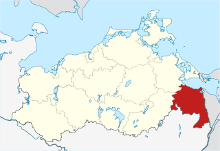
Uecker-Randow was a Kreis (district) in the eastern part of Mecklenburg-Western Pomerania, Germany. Neighboring districts were Uckermark in Brandenburg, Mecklenburg-Strelitz and Ostvorpommern. To the east was the West Pomeranian Voivodship of Poland.
Uckermark is a Kreis (district) in the northeastern part of Brandenburg, Germany. Neighbouring districts are Barnim and Oberhavel, the districts Mecklenburgische Seenplatte and Vorpommern-Greifswald in Mecklenburg-Vorpommern, and to the east Poland. It is one of the largest districts of Germany areawise. The district is named after the historical region of Uckermark.

The history of Pomerania starts shortly before 1000 AD, with ongoing conquests by newly arrived Polan rulers. Before that, the area was recorded nearly 2000 years ago as Germania, and in modern times Pomerania has been split between Germany and Poland. Its name comes from the Slavic po more, which means "land at the sea".

Gartz is a town in the Uckermark district in Brandenburg, Germany. It is located on the West bank of the Oder River, on the border with Poland, about 20 km south of Szczecin, Poland. It is located within the historic region of Western Pomerania.
Ueckermünde is a seaport town in northeast Germany, located in the district of Vorpommern-Greifswald, Western Pomerania, near Germany's border with Poland's Police County.

Burg Stargard is a small town in the Mecklenburgische Seenplatte district, in Mecklenburg-Vorpommern, Germany. It is situated 8 kilometres (5.0 mi) southeast of Neubrandenburg.

The Mecklenburg Lake Plateau or Mecklenburg Lakeland is the largest coherent lake and canal region in Germany and is sometimes called "the land of a thousand lakes". There are several nature parks and well-known lakes with unique flora and fauna in the region, such as the Müritz, the biggest German lake lying entirely within Germany, the Plauer See, the Fleesensee, the Tollensesee, the Schmaler Luzin and the Kölpinsee.

The Uecker or Ucker is a river in the northeastern German states of Brandenburg, where it is known as the Ucker, and of Mecklenburg-Vorpommern. Its source lies in the Uckermark district, one kilometer north of Ringenwalde. It flows northward through several lakes. The first one is Großer Krinertsee. The next ones are rather small.

Löcknitz is a municipality in the Vorpommern-Greifswald district, in Mecklenburg-Vorpommern, in north-eastern Germany, located in the historic region of Pomerania, 12 km (7 mi) west of the German-Polish border and 25 km (16 mi) west of Szczecin. It is the seat of the Amt Löcknitz-Penkun.

Fahrenwalde is a municipality in the district of Vorpommern-Greifswald in the east of the German federal state Mecklenburg-Vorpommern. It is administrated by the Amt Uecker-Randow-Tal, which is based in Pasewalk.
The Uckermark is a historical region in northeastern Germany, which currently straddles the Uckermark District of Brandenburg and the Vorpommern-Greifswald District of Mecklenburg-Vorpommern. Its traditional capital is Prenzlau.
Pomerania during the Late Middle Ages covers the history of Pomerania in the 14th and 15th centuries.
History of Pomerania (1945–present) covers the history of Pomerania during World War II aftermath, the Communist and since 1989 Democratic era.

The Bezirk Neubrandenburg was a district (Bezirk) of East Germany. The administrative seat and the main town was Neubrandenburg.

The Helpt Hills are the highest natural elevation in the northeast German state of Mecklenburg-Vorpommern reaching a maximum height of 179.2 metres (588 ft) above sea level (NHN). The hills are a terminal moraine formed during the Pomeranian stadium of the Weichselian glaciation and were named after the village of Helpt on their northern slopes.

The Bützow–Szczecin railway is a nearly 200 km-long, mostly non-electrified, single-track main line railway running mostly in the German state of Mecklenburg-Vorpommern. The first section of the line between Bützow and Güstrow was opened in 1850 by the Mecklenburg Railway Company and is one of the oldest railways in Germany and is part of the Leipzig–Magdeburg–Schwerin–Rostock main line.

Historical Western Pomerania, also called Cispomerania,Fore Pomerania, Front Pomerania or Hither Pomerania, is the western extremity of the historic region of Pomerania forming the southern coast of the Baltic Sea, located mostly in north-eastern Germany, with a small portion in north-western Poland.


