
Hallamshire is the historical name for an area of South Yorkshire, England, approximating to the current City of Sheffield local government area.
Darton is a large village in the Metropolitan Borough of Barnsley, on the border with West Yorkshire, England. At the time of the 2001 UK census, it had a population of 14,927, increasing to 21,345 for both Darton Wards at the 2011 Census.

Barkston Ash is a small village and civil parish close to Selby in North Yorkshire, England. It was formerly known as Barkston, in the West Riding of Yorkshire. In 2011 the parish had a population of 370.

Fryup is a hamlet in the North York Moors National Park in North Yorkshire, England. It is within the civil parish of Danby, and is located alongside Great Fryup Beck in Great Fryup Dale.
Wressle is a village and civil parish in the East Riding of Yorkshire, England, lying on the eastern bank of the River Derwent approximately 3 miles (5 km) north-west of Howden.

Holme is a village in the Holme Valley civil parish of Kirklees in West Yorkshire, England. The village straddles the A6024 road between Holmbridge and Lane village, 2.5 miles (4 km) south-west of Holmfirth. It is close to the boundaries of Derbyshire and the Peak District National Park: some properties lie outside of the National Park. Holme Moss, an area of high moorland with a prominent transmitter mast, overlooks the village from the south-west.

Flockton is a village in the civil parish of Kirkburton, in Kirklees, West Yorkshire, England. It is halfway between Huddersfield and Wakefield. In 2020, the population of Flockton and Flockton Green was estimated to be 2,107.

Gilling East is a village and civil parish in North Yorkshire, England, on the main B1363 road between York and Helmsley, 2 miles (3.2 km) south of Oswaldkirk and 5 miles (8 km) south of Helmsley. It is named "East" to distinguish it from Gilling West near Richmond, some 32 miles (51 km) away. It had a population of 321 at the 2001 Census, which had risen to 345 at the 2011 census. In 2015, North Yorkshire County Council estimated the population to be 360. The village lies in the Howardian Hills just south of the North York Moors National Park and close to Ampleforth Abbey and College.

Hepworth is a village and former civil parish, now in the parish of Holme Valley, in the metropolitan borough of Kirklees, in West Yorkshire, England. It is southeast of Holmfirth and southwest of Jackson Bridge. In 1931 the parish had a population of 840.
Cottingley is a suburban village within the City of Bradford district in West Yorkshire, England between Shipley and Bingley. It is known for the Cottingley Fairies, which appeared in a series of photographs taken there during the early 20th century.

Rookwith is a hamlet and civil parish in the former Hambleton District of North Yorkshire, England, about 4 miles (6.4 km) west of Bedale and near the flow of the River Ure. The hamlet was mentioned in the Domesday Book as belonging to Count Alan and having four ploughlands.
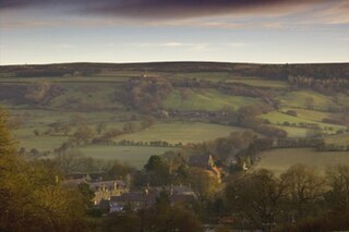
Rosedale Abbey is a village in the Ryedale district of North Yorkshire, England. It is approximately 8 miles (13 km) north-west of Pickering, 8 miles south-east of Castleton and within Rosedale, part of the North York Moors National Park.

Rosedale is a valley located almost in the centre of the North York Moors national park in North Yorkshire, England. The nearest town is Kirkbymoorside, 7 miles (11 km) to the south. Rosedale is surrounded by moorland. To the north-west sits Blakey Ridge at over 1,300 feet (400 m) above sea level. At Dale Head is the source of the River Seven, which flows down the valley to join the River Rye at Little Habton near Malton. At its southern end Rosedale is squeezed between Spaunton Moor and Hartoft Rigg, where the river flows out through Forestry Commission woodland before passing the village of Cropton to reach the plains of the Vale of Pickering.
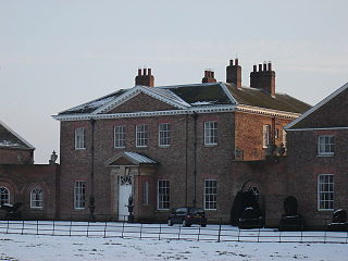
Houghton Hall, Sancton, near Market Weighton, is a Grade I listed Georgian country mansion in the East Riding of Yorkshire, England, set in an estate of 7,800 acres (32 km2). Located on the estate is the village of Sancton and the vestigial remains of the ancient hamlet of Houghton. It was built c. 1765–8 by Philip Langdale to the designs of Thomas Atkinson and underwent minor remodelling in 1960 by Francis Johnson. It is built in pink brick with stone dressing and slate roof, with a three-storey, 5-bay main block.

Shaftholme is a small hamlet in South Yorkshire, England, in the parish of Arksey that is located half a mile north of Bentley and two miles north of Doncaster.

Cowthorpe is a village in the civil parish of Tockwith, in North Yorkshire, England. It is situated 3 miles (4.8 km) north of Wetherby, 10 miles (16 km) east of Harrogate, 7 miles (11 km) from Knaresborough and 13.5 miles (21.7 km) from York.

Stainsacre is a village in the civil parish of Hawsker-cum-Stainsacre in North Yorkshire on the edge of the North York Moors National Park. It lies 2 miles (3.2 km) south-east of Whitby, near the A171 road.

Crow Edge is a hamlet in Dunford civil parish, situated on the A616, two miles southeast of Hepworth, West Yorkshire in the metropolitan borough of Barnsley, South Yorkshire, England.

Deepdale is a hamlet in Langstrothdale in the Yorkshire Dales in the north of England. The hamlet is 6.5 miles (10.5 km) northwest of Kettlewell and 15 miles (24 km) north of Settle. The hamlet was originally in the wapentake of Staincliffe and has been written as Deep Dale, Deep-Dale and Deepdale.
Hang East was a Wapentake (Hundred), which is an administrative division, in the historic county of the North Riding of Yorkshire. It was one of the smaller wapentakes by area and consisted of nine parishes and two towns; Bedale and Masham.

