Barony of Kersland

Last updated

Kersland Manor House
Dalry, North Ayrshire, Scotland
UK grid reference NS30655083
Kersland Castle ruins.JPG
Kersland Castle and barmkin.
Scotland relief location map.jpg
Red pog.svg
Kersland Manor House
Coordinates 55°43′16″N4°41′49″W / 55.720987°N 4.696817°W / 55.720987; -4.696817
TypeTower
Site information
OwnerPrivate
Controlled byClan Kerr
Open to
the public
No
ConditionRuined
Site history
Built15th century
In useUntil 18th century
MaterialsStone

The remains of the old castle of Kersland lie about 1.5 miles to the north-east of the town of Dalry in North Ayrshire, Scotland, in the old Barony of Kersland. The River Garnock lies nearby.

Contents

The history of Kersland

The Barony

Kersland House. Kersland House.JPG
Kersland House.

The Barony of Kersland was once extensive, however after the days of the Kerrs the land was parcelled out and the mid-superiority purchased by John Smith of Swineridgemuir (sic) after having been held by the Kerr family for upwards of 500 years. [1] In the 15th century the parish had four other baronies: Kelburne, Blair, Lynn and Pitcon. [2] The Kerslands proper sat on a bank shelving towards the River Garnock, comprising the properties of Kersehead, the Coalheugh-glen, the Tod-hills, the Brown-hills, the Davids-hills, and Auchengree, amounting to about 700 acres of arable land. [1]

The Manor house

The old East Kersland Farm Kersland House and farm.JPG
The old East Kersland Farm
The carved stone Kersland House Date Stone and Coat of Arms.JPG
The carved stone

The ancient mansion or castle [3] of Kersland stood on Easter (now 'East') Kersland Farm. The remains of the 'L-Plan' tower has been built into the farmhouse. The barmkin wall survives and has a surviving strong defensive corner tower. [4] Paterson records that the house was almost entirely pulled down by the feuar, Robert Ker. [5] The remaining two barrel vaulted chambers, later used as a dairy and stable, with walls 8 ft thick, until recently formed part of the offices attached to East Kersland.

Over the main entrance door of the dwelling house is a carved stone removed from the old manor house bearing the arms of the Ker family, with an inscription "Daniel Ker Kersland - 1604". This date stone has been touched-up with paint. [6] Karrisland (sic) is recorded on Timothy Pont's map c.1604, as are the placenames Karshead, Todsle, Dysil, and Achingry. [7] In 1685 'Carsland' is shown. [8] The property had been surrounded by trees and had a orchard of considerable extent. [9] Kersland Mains was on the entrance lane from Dalry and became Wester Kersland Farm when the manor house/castle was demolished.

The Barony mills

The Linn Spout or Tianna Falls near Longbar. Kersland Mill falls.JPG
The Linn Spout or Tianna Falls near Longbar.
East Kersland Farm and site of the old sawmill. East Kersland Mill and farm.JPG
East Kersland Farm and site of the old sawmill.

Most baronies had a water mill which was under the control of the laird or lord and to which the tenants were thirled or obliged to go to have their grain ground into flour. A proportion of the grain was taken as payment. Thirlage ended in the late 18th century and resulted in a number of mills being abandoned once market forces took a hold. Kersland Mill on the Powgree Burn lies just downstream of the Tianna Falls in the Kersland Glen and is recorded on Timothy Pont's map c.1604. [7] Robert Spier, writer and bank agent in Beith was descended from the Spier's of Kersland Mill which he purchased from his elder brother. [10] In 1852 Captain John Russell of Maulside acquired Kersland Mill and the mill lands. [11]

A sawmill also existed at East Kersland with associated mill pond and settlement ponds and sluices. Originally the mill was fed by water from the old Kersloch near Kerselochmuir, carried to the site in an underground culvert and later by the muir alone. The mill had several dams and three mill ponds which have now been infilled.

The barony and associated families

The Kers of Kersland

Datestone and coat of arms from the old castle. Kersland House Date Stone and Coat of Arms.JPG
Datestone and coat of arms from the old castle.

The place name 'Kerse' used for the farms and the bridge at the northern end of the loch refers in Scots to 'Low and fertile land adjacent to a river or loch'. [12] The old Barony of Kersland was held by the Ker (latterly Kerr) family and the name of the barony derives from them. The Kers of Kersland appear to be the oldest representatives of the family in Scotland. [1]

The arms of the Kers of Kersland were a chevron, charged with three stars or mollets. The motto was "Praise God". The coat of arms were displayed at Dalry church. [5]

A local tradition suggests that two sons of Kersland were found guilty of, or at least being involved in the slaughter of a Laird of the Blair; they at first took refuge in England, but afterwards settled on the Border. One of these sons is said to have been Ralph Ker, who was founder of the Kers of Ferniehirst; while the other is stated to have been the founder of Kers of Cessford. [13]

A William de Ker is recorded in 1205 as holding land in the Dalry area and his son William (d. 1305) inherited in 1292, one of the Scottish barons who submitted to the rule of Edward I. Finlaio de Kerr, succeeded in 1362, followed by Willielmi Ker in 1421. Robert Ker, was slain at Flodden in 1513, leaving 2 sons, John and Robert. John Ker succeeded his father at Kersland. Robert Ker, the second son, took over Auchengree and his descendants became known as the Kers of Auchengree. John Ker of Kersland succeeded his father. John Ker married Lady Agnes Montgomerie in 1530, the daughter of Hugh Montgomerie, the first Earl of Eglinton, and Helen Campbell of Argyle. Both John and Agnes were born after 1478. Agnes died on 26 October 1596.[ citation needed ]

Robert Ker of Kersland, succeeded his father and married Agnes Montgomerie, daughter of Hugh of Hessilhead in 1556. The couple had no sons, but three daughters, Janet, Margaret and Jean. Margaret married Patrick Maxwell of Dargavel and Jean married Gavin Ralston of Ralston. Janet Ker married the famous Captain Thomas Crawford of Jordanhill [14] who captured Dumbarton Castle from Mary Queen of Scots supporters during the minority of James VI. The couple had two sons, Daniel (b. c 1539) and Hugh, the latter inheriting the lands of Jordanhill. [15] [14] Crawford died on 3 January 1603 and is entombed at Kilbirnie Auld Kirk with Janet.

The Crawfurd Kers (Jordanhill)

A view from the old millponds site of Pitcon Woods and Dalry. Dalry and Pitcon from near old East Kersland Mill.JPG
A view from the old millponds site of Pitcon Woods and Dalry.
The tomb of Thomas and Janet Craufurd at Kilbirnie. Craufurds Tomb in Kilbirnie Auld Kirk cemetery.JPG
The tomb of Thomas and Janet Craufurd at Kilbirnie.

Daniel Crawfurd adopted the name and arms of Ker of Kersland [14] and married first Annabella Campbell, daughter of Sir Matthew Campbell of Loudoun, Sheriff of Ayr, and second Isobel Drummond, in about 1578 at Loudoun, Ayrshire. Annabella was born about 1543 at Loudoun Castle, Ayrshire. They had seven children: Hugh (Hew), John, Isobel, Margaret, Janet, Anna, and Susanna. Isobel married Robert Kerr of Trearne. Daniel appointed Robert Ker as Executor for his son Hugh. Anna married George Campbell of Cessnock. Susanna married Colonel Campbell of Ellengreig. John Ker became Laird of Brackenhill or Bankhill. Daniel Ker died in 1613.[ citation needed ]

Hugh Crawfurd Ker was born about 1560, and succeeded his father in 1613 and married Jean Blair, daughter of Blair of that Ilk in 1640, having three children, Robert, Margaret and Annabella. Margaret married William Scott of Cambeith. Annabella married William Dunlop of Bloak. Robert Ker married Barbara Montgomerie, daughter of Robert Montgomerie of Hessilhead. They had six children: Robert, Daniel, Jean, Margaret, Anna and Elizabeth. Robert, the eldest son, had no issue. Daniel succeeded his father. Margaret married Rev. Thomas Linning of Lesmahagow. Jean married Major William Borthwick. Elizabeth married Alexander Porterfield, a surgeon in Glasgow. Anna married John Crawfurd of Fergushill.

Robert Kerr the Covenanter

Robert Ker lost his estates as a leading covenanter and died in Holland in 1680. His family were very religious and in 1666 he joined the Laird of Caldwell and a number of others with the intention of joining Colonel Wallace and others who had renewed the Covenant at Lanark. General Dalziel's troops disposition forced them to abandon their plans and after being betrayed by Laird of Caldwell he was forced to flee to Holland where he lived with his family in Utrecht for three years. His confiscated estate was given to General Drummond of Cromlie and his Beith lands were given to William Blair of that Ilk; they held these lands until the Reformation. [16] Business required him to return to Scotland which he did shortly after his wife who had returned to lodgings in Edinburgh at the end of 1669. He lodged elsewhere however his wife took ill and he was betrayed and taken prisoner when visiting her. [16] For three months he was kept in Edinburgh and then taken to Dumbarton Castle where he was imprisoned for 18 months until moving for three winter months to Aberdeen to be kept in solitary confinement and denied a fire. Stirling Castle was his next destination and he remained there for several years until a return to Dumbarton Castle that lasted until October 1677. [17]

Irvine was to be his next place of confinement although he was to be permitted to have his family join him. Robert visited Glasgow to collect his wife and their five children and was to be detained in the tolbooth overnight, however a fire broke out and after a refusal of the magistrates to open the doors the citizens of the city released them using ladders. Fearing further confinement he took refuge with a group of persecuted ministers and attended a conventicle at Maybole before returning to Utrecht in 1678 where he remained until his death in 1680. [18]

Drummond

Robert Ker was indicted with treason during the Covenanting 'Killing Times' and his lands were given to Lieutenant-General William Drummond of Cromlix in the 1680s. The forfeiture was rescinded and the estates were restored. [19] Another source gives Daniel Ker as the member of the family who held the estate at the time. [20]

The Borthwick Kers

The old lane leading to the Kerslands. Kersland Lane.JPG
The old lane leading to the Kerslands.
Arrow and gun slit - an embrasure. Kersland Castle embrasure, Dalry, North Ayrshire, Scotland.jpg
Arrow and gun slit - an embrasure.

Daniel Crawfurd also took the name and arms of the Ker family and inherited the lands of Kersland within this extensive Barony of Kersland. [1] He was a made a major in the Earl of Angus' (Cameronian) regiment, and was killed at the Battle of Steinkirk in 1692. [21] He was unmarried and his sister, Jean Ker, married Major William Borthwick of Johnstonburn, and inherited Kersland. In 1697, they sold the estate to her sister Anna, wife of John Crawfurd of Fergushill. [21] John Crawfurd was born August 8, 1673, at Crawfurdland and married Anna c.1703 at Kersland. He assumed the name and title John Ker of Kersland, dying on 8 July 1726 in Debtor's Prison, London,[ citation needed ] having first written his "Memoirs and Negotiations" which were later published. [21] He was buried in Southwark on the north side of Saint George's churchyard. [22]

John Ker was survived by three daughters of whom, Anna and Jean died apparently unmarried. His daughter Elizabeth married John Campbell "of Ellengreig", also 'Ellan-Dheirrig' or 'Ellan-Gheirrig', a small island in Loch Riddan, in the parish of Inverchaolain, Argyllshire. Elizabeth and John Campbell had no children. Elizabeth was the last to take the title 'Lady Kersland' and died impoverished at the house of John Ker, a Beith merchant, where she had lived for many years, being buried in the Hessilhead tomb, Beith. [23] Anna and Jean, sisters to Elizabeth, sold the barony and property to William Scot of Bavelaw in 1736. They had been forced to sell to pay off their father's many creditors.[ citation needed ]

The Scots

William Scot of Bavelaw purchased the barony and his son Lawrence divided the Mains of Kersland into two farms, Easter and Wester Kersland, feuing Easter to Robert Ker and Wester to James Kirkwood. Lawrence had a son Charles who borrowed so much money against the feu-duties that upon his death the barony in 1801 was sold. At this time John Smith of Swindridgemuir purchased the mid-superiority. [5]

Kersland Barony church and school

The Church of Scotland school at Barkip aka The Den had an average attendance of 137 pupils in 1891 and was named for the old barony. [24]

Industrial history

The site of Kersland Row at the site of the old ironstone pit and later the brickworks. Kerland Row, Dalry.JPG
The site of Kersland Row at the site of the old ironstone pit and later the brickworks.

Several ironstone pits were located in the area, such as the Kersland Pit which was rail connected, together with sandstone quarries, brickworks and coal mines, including the Kersland Colliery above Highfield. A miner's row was located near the Kersland pit at West Kersland. [25]

Micro-history

An Irish connection exists as John Roche of Ballickmahon, in the parish of Crossmolina, barony of Tyrawley, married Janet, daughter of Robert Kerr of Kersland. [26]

Margaret Blair married a Kerr of Kersland and obtained a charter of the lands of Trearne for herself and her son Robert in January 1594. [27]

Smith records that the sword of Kerr of Kersland was preserved "in Dr. Grierson's museum at Thornhill", and was one of the longest and heaviest in the collection. [28]

See also

Related Research Articles

Beith is a small town in the Garnock Valley, North Ayrshire, Scotland approximately 20 miles south-west of Glasgow. The town is situated on the crest of a hill and was known originally as the "Hill o' Beith" after its Court Hill.

<span class="mw-page-title-main">Hessilhead</span> Area in North Ayrshire, Scotland

Hessilhead is in Beith, North Ayrshire, Scotland. Hessilhead used to be called Hazlehead or Hasslehead. The lands were part of the Lordship of Giffen, and the Barony of Hessilhead, within the Baillerie of Cunninghame and the Parish of Beith. The castle was situated at grid reference NS380532.

<span class="mw-page-title-main">Barony and Castle of Giffen</span> Barony in the former District of Cunninghame, now North Ayrshire

The Barony of Giffen and its associated 15th-century castle were in the parish of Beith in the former District of Cunninghame, now North Ayrshire. The site may be spelled Giffen or Giffin and lay within the Lordship of Giffin, which included the Baronies of Giffen, Trearne, Hessilhead, Broadstone, Roughwood and Ramshead; valued at £3,788 9s 10d. The Barony of Giffen comprised a number of properties, including Greenhills, Thirdpart, Drumbuie, Nettlehirst and Balgray, covering about half of the parish of Beith. Giffen was a hundred merk land, separated from the Barony of Beith, a forty-pound land, by the Powgree Burn which rises on Cuff hill. The Lugton Water or the Bungle Burn running through Burnhouse may have been the Giffen barony boundary with that of the adjacent barony and lands of Aiket castle.

<span class="mw-page-title-main">Highfield, North Ayrshire</span> Human settlement in Scotland

Highfield is a small village or hamlet in North Ayrshire, Parish of Dalry, Scotland. It is situated between the settlements of Barkip and Dalry on the A737 at a junction with the B777. It lies in the lands of the old Barony of Kersland, the ruins of Kersland Castle and East Kersland Mill being situated nearby at East Kersland.

<span class="mw-page-title-main">Kilbirnie Auld Kirk</span> Church

Kilbirnie Auld Kirk is a Church of Scotland congregation on Dalry Road, Kilbirnie, North Ayrshire, Scotland. Although the building dates back to the 15th century, the present congregation was formed in 1978 by the amalgamation of the Glengarnock Parish Church and the Barony Church.

<span class="mw-page-title-main">Barony of Aiket</span> Barony in Scotland

The Barony of Aiket with its castle, lay within the old feudal bailiary of Cunninghame. The barony lands equate to the extant Parish of Dunlop, East Ayrshire, Scotland.

<span class="mw-page-title-main">Broadstone Castle</span> Castle in Ayrshire, Scotland

Broadstone lies close to the small village of Gateside in North Ayrshire, Scotland about half a mile east of Beith in the old Barony of Giffen.

<span class="mw-page-title-main">Hill of Beith Castle</span>

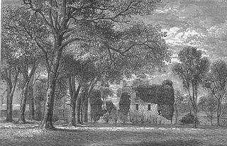
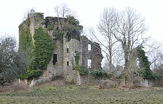
The old Barony and castle, fortalice, or tower house of Hill of Beith lay in the feudal Regality of Kilwinning, within the Baillerie of Cunninghame, and the Sherrifdom of Ayr, now the Parish of Beith, North Ayrshire, Scotland.

<span class="mw-page-title-main">Loch Brand</span> Drained freshwater loch in North Ayrshire, Scotland

Loch Brand or Loch of Boghall was a loch situated in a depression between the Grange Estate, Crummock, Hill of Beith Castle site and Boghall in the Parish of Beith, North Ayrshire, Scotland. The loch was fed by the Grange Burn and surface runoff, such as from the old rig and furrows indicated by Roy's Maps of the mid 17th century. The loch was drained by the Boghall Burn that runs passed the 'Court Hill' and into Powgree Burn at Gateside.

<span class="mw-page-title-main">The Lands of Pitcon</span>

The Lands of Pitcon, previously Potconnel now form a small estate of around 100 acres in the Parish of Dalry, North Ayrshire in the old Barony of Dalry. The present category B listed Georgian mansion house dating from 1787, replaces an older castellated dwelling. Pitcon lies on the outskirts of Drakemyres, now a suburb of Dalry, close to the confluence of the Rye Water, River Garnock, and the Mains Burn, standing on a low knoll. Such a marshy area would have provided a degree of protection to the old castle.

The Lands of Cocklebie or Cocklebee formed an estate possessing a common border with the estates of Lainshaw, the Corsehill, and the town of Stewarton, East Ayrshire, Parish of Stewarton, Scotland.

<span class="mw-page-title-main">Barkip</span> Human settlement in Scotland

Barkip, also known as The Den, is a hamlet in North Ayrshire, Scotland about three miles southwest of Beith on the A737 road to Dalry. The earliest recorded name is 'Blairkip'. In the Gaelic language, the name Barkip comes from bar ("top"), and kip. It is not clear when or why the name 'The Den' started to be used although it appears in the local press as both in 1898, however in Scots as in old English one meaning is 'A hollow between hills,' which is certainly an accurate description of the geography of the area that Barkip lies in. Following construction of a new road, Barkip no longer sits on the main Beith to Dalry road.

<span class="mw-page-title-main">Lands of Bogston</span>

Bogston or later Bogstone was a small estate in the old Barony of Giffen near Barrmill in the Parish of Beith, North Ayrshire, once held by collateral descendants of the Montgomeries of Broadstone. The estate covered 160 acres or around 65 hectares, its rental in 1896 being £180 per annum.

<span class="mw-page-title-main">The Lands of Roughwood</span>

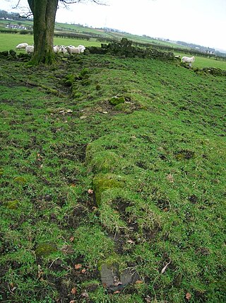
Roughwood once Ruchwood is a farm, originally a estate, possessing at one time a small tower castle. Roughwood is situated near to the town of Beith in North Ayrshire, Scotland; the lands lay within the old Lordship of Giffen.

<span class="mw-page-title-main">Barony and Castle of Kilbirnie</span> Barony and castle west of the town of Kilbirnie in North Ayrshire, Scotland

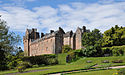
The substantial remains of the old castle and sixteenth century manor house of Kilbirnie lie west of the town of Kilbirnie in North Ayrshire, Scotland, on the lower slopes of the Glengarnock Hills, in the old Barony of Kilbirnie. The building is also variously known as the Place of Kilbirnie, The Place, or Kilbirnie House.

Swindridgemuir House and estate were composed of the 'Lands of Swindridgemuir' and the dwelling house about two miles north-east of Dalry in the old Barony of Kersland, about a mile and a half north of the Blair Estate, North Ayrshire, Scotland. The spelling on the family memorials at Ayr Auld Kirk is 'Swindrigemuir'.

<span class="mw-page-title-main">Lands of Willowyard</span>

The ancient lands of Willowyard, Willieyeards, Williyard or Willizeards were part of the holdings of the Regality of Kilwinning, Barony of Beith, and Bailiary of Cuninghame. They later became the property of the Montgomerie family before being sold to the Simson family in 1723. The manor house still survives as part of a business premises and the nearby industrial estate and whisky bond carry the name 'Willowyards'.

<span class="mw-page-title-main">Lands of Marshalland</span>

The lands of Marshalland, Marsheland, Marsheyland or Marshyland were part of the holdings of the Barony of Beith, Regality of Kilwinning and Bailiary of Cuninghame. They became the property of the Lyle family, then the Shedden family, passing next to the Spier's family before finally becoming part of the Spier's Trust lands. The laird's house and farm were demolished in the 1960s.

<span class="mw-page-title-main">Fairlie Castle</span>

Fairlie Castle is a restored oblong tower castle located on a natural rounded knoll situated above a precipitous section of the Fairlie Glen near the town of Fairlie in the old Barony of Fairlie, Parish of Largs, North Ayrshire, Scotland. It was built by the now extinct family, the Fairlies of that Ilk and survives in a fairly good state of preservation. It is a protected scheduled monument.

Robert Ker (the younger) known as Robert Ker of Kersland was a Covenanter. He sympathised with the insurgents who fought at Rullion Green and consequently was declared a rebel and his lands became forfeit. He escaped to Holland but following his wife home on business he was captured while visiting her in her sick-bed in Edinburgh. He spent many years in various jails. He is remembered by Christian historians and biographers such as Wodrow and Howie as one who suffered for the Presbyterian cause in Scotland.

References

Notes
  1. 1 2 3 4 Topographical Description of Ayrshire Retrieved : 2012-05-27
  2. Ayrshire Paths Retrieved : 2012-05-27
  3. Coventry, Page 307
  4. Campbell, Page 198
  5. 1 2 3 Paterson, Page 184
  6. RCAHMS Retrieved: 2012-05-27
  7. 1 2 Blaeu's map Retrieved : 2012-05-27
  8. Adair's map Retrieved : 2012-05-27
  9. Dobie, Page 250
  10. Spier's Dedication speech
  11. Dobie, Page 326
  12. Scots Dictionary Retrieved : 2012-05-27
  13. Kerr History Retrieved : 2012-05-27
  14. 1 2 3 Robertson, Page 236
  15. The Coila Repository and Kilmarnock Magazine Retrieved : 2012-05-27
  16. 1 2 Bonar, Page 423
  17. Bonar, Page 424
  18. Bonar, Page 425
  19. Paterson, Pages 181-182
  20. Jardine's Book of Martyrs.
  21. 1 2 3 Page 210
  22. Dobie, Page 249
  23. Paterson, Page 183
  24. Ordnance Gazetteer Retrieved : 2012-05-26
  25. OS map Retrieved : 2012-05-27
  26. "The Irish landed gentry when Cromwell came to Ireland" Retrieved : 2012-05-27
  27. Robertson, Page 87
  28. Ayrshire Roots Retrieved : 2012-05-27
Sources
  1. Bonar, Rev Andrew A. (1879). The Scots Worthies according to Howie's Second Edition, 1781. Glasgow : McGready, Thomson & Dunedin.
  2. Campbell, Thorbjørn (2003). Ayrshire. A Historical Guide. Edinburgh : Birlinn. ISBN   1-84158-267-0.
  3. Coventry, Martin (2010). Castles of the Clans. Musselburgh : Goblinshead. ISBN   1-899874-36-4.
  4. Dedication Speech of the Spier School by B. W. Cochran-Patrick of Ladyland & Woodside. 28 April 1887.
  5. Dobie, James D. (ed Dobie, J.S.) (1876). Cunninghame, Topographized by Timothy Pont 1604–1608, with continuations and illustrative notices. Glasgow: John Tweed.
  6. Gilbert, Thomas & Grace (2010). Windyhouse Farm.
  7. Jamieson, Sheila (1997). Our Village. Greenhills Women's Rural Institute.
  8. Paterson, James (1866). History of the Counties of Ayrs and Wigton. Vol. III. Cuninghame. Parts 1 & 2. Edinburgh : James Stillie.
  9. Robertson, George (1820). A Topographical Description of Ayrshire: More particularly of Cunninghame, etc. .... Irvine : Cunninghame Press.
  10. The New Statistical Account of Scotland. 1845. Vol. 5. Ayr - Bute. Edinburgh : Blackwood & Sons.