Barrax

Last updated
Barrax
Plaza barrax.jpg
Bandera Barrax.jpg
Flag
Escudo de Barrax.svg
Coat of arms
Albacete Barrax Mapa municipal.png
Location of Barrax
Coordinates: 39°02′45″N2°12′10″W / 39.04583°N 2.20278°W / 39.04583; -2.20278 Coordinates: 39°02′45″N2°12′10″W / 39.04583°N 2.20278°W / 39.04583; -2.20278
Municipality Spain
Autonomous
community
Castilla-La Mancha
Province Albacete
Mancomunidad La Mancha-Centro Júcar
Government
  MayorJosefa Perez Navarrete (2007)
Area
  Total189.86 km2 (73.31 sq mi)
Elevation
731 m (2,398 ft)
Population
 (2018) [1]
  Total1,864
  Density9.8/km2 (25/sq mi)
Demonym(s) Barrajenses
Barrajeño,-ña
Area code(s) 967
Province code02
Municipal code015
Distance from Albacete 29 km (18 mi)

Barrax is a municipality in the province of Albacete. This province belongs to the Autonomous Community of Castile-La Mancha (Spain). It is located on the plateau begins the Alcaraz mountain range. It is a mainly agricultural town surrounded by large areas of cereals.

Contents

History

The origin of this population, according to tradition as there are no corroborating documents, was the call Barraj sale, old coaching inn on the road between Andalusia and the center of the peninsula and the Levant, belonging then to the jurisdiction of Alcaraz, which became independent on September 20, 1564 when he was awarded the title of Villa by royal grant of Philip II of Spain.

The matching documents are referred to the year 1601, which date from the early inscriptions of the parish archives.

The first known water capacity Barrax is opposite the church of San Roque. It is a well that is currently blocked and two other wells on the outskirts of town to Munera. Later he brought the water of El Cornudillo, farm near the border with the municipality of Lezuza and the deposit was located near the Windmill. Still remains, although not very good. Tails were typical of pitchers in the ancient square of the Colonels Montoya, today "Sunday Castillejo Mayor." After that the well of the "La Morra" on October 16, 1966, as mayor Eugenio Fernández Cuenca. On October 24, 1966, the day of San Rafael, would the water to the Plaza Mayor.

Notable buildings

Parish Church of the Immaculate Conception: the neoclassical style and located in the Plaza Mayor, across from City Hall was completed in 1766, during the reign of Carlos III. Suffered severe damage during the Civil War. In 1945 there was a collapse that forced the repair and the subsequent reform of the tower, it was restored in 2001. Ermita de San Roque is located within the village and was rebuilt in 1884. In 2006 the chapel was restored, and during those works were original frescoes, dating from the early 16th century.[ citation needed ] New City Hall, located on the grounds of the former home of Lodares. It highlights their porch restored in 2006. It was recently[ when? ] discovered containing shields brought from the north of Spain dated on the 15th century, but in general the porch belongs to the 16th century. Ermita del Cristo del Perdon: This site was rebuilt in 1997 and redesigned by the priest Don Felix Ibarguchi. Within it is a modern Stations of the Cross spread throughout the house, also designed and conducted by the pastor. In this chapel is the statue of Christ of Forgiveness, which is a replica of the original image, burned during the Civil War by the Republicans. Windmill Barrax: Barrax this symbol, is on top of all villa. In 2006, a large walk opened in parks for children, fitness, camping tables and green areas for the enjoyment of local people and visitors. Its origin is remote, has been restored several times, the first time by Don Benjamín Palencia.[ citation needed ]

Attractions

At Finca Las Tiesas have been several scientific campaigns financed by the European Space Agency (DAISEX, SEN2FLEX). They desire this location because of its flat terrain, regularly clear skies, and crops grown under controlled conditions of alfalfa and barley, among other factors. This makes it particularly interesting Barrax from the point of view of Remote Sensing.[ citation needed ] So Barrax is known throughout Europe among scientists dedicated to Earth observation Metal framed by the special gathering this county.[ citation needed ] In the municipality of Barrax, at 740 m above the plain, is the hill called "Hill of the three bishops," so named because it is the converging point in the bishoprics of Toledo, Cuenca, Cartagena until it created the Diocese of Albacete in 1950, which was incorporated in 1996 Barrax. Cerro de Santa Quiteria, the festival is held here in honor of Santa Quiteria. This mountain gives way to the landscape of La Mancha.[ citation needed ] "The fourth Philemon" This place is situated in a valley, just past the hill of Santa Quiteria. In the center of this valley, is the "Fourth Philemon" is an ancient village.[ citation needed ] A 15th-century Arab cistern is located about 300m towards Villarrobledo Barrax.[ citation needed ]

Festivals

Pilgrimage in honor of Santa Quiteria is on May 22. It goes in procession to the shrine located in the homonym hill on a stretcher bearing the image. This procession has its origins in a snack made by the friends of a priest, after its mother for her birthday, on the hill of Santa Quiteria. This was repeated until it became a pilgrimage. Celebrations in honor of San Roque (13 to 17 August), with its famous bull of fire. August 15 is a tribute to the Virgen de Agosto, 16 to San Roque and San Roquillo 17. In every village, festival takes place the traditional fire Toro consisting of men, in mobile structures horn-shaped and filled with fireworks, running through the streets leading to fun runs and among those attending the celebration.

Related Research Articles

Castilla–La Mancha Autonomous community of Spain

Castilla–La Mancha, or Castile La Mancha, is an autonomous community of Spain. Comprising the provinces of Albacete, Ciudad Real, Cuenca, Guadalajara and Toledo, it was created in 1982. It is bordered by Castile and León, Madrid, Aragon, Valencia, Murcia, Andalusia, and Extremadura. It is one of the most sparsely populated of Spain's regions. Albacete is the largest and most populous city. The government headquarters are in Toledo and the High Court headquarters are in Albacete.

Province of Cuenca Province of Spain

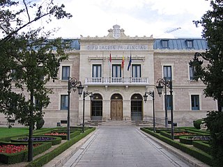
Cuenca is one of the five provinces of the autonomous community of Castilla-La Mancha. It is located in the eastern part of this autonomous community and cover over 17,141 square km. It has a population of 203,841 inhabitants- the least populated of its autonomous community. Its capital city is Cuenca and the province is compounded of 238 municipalities.

La Mancha Natural region in Spain

La Mancha is a natural and historical region located in the Spanish provinces of Albacete, Cuenca, Ciudad Real and Toledo. La Mancha is an arid but fertile plateau that stretches from the mountains of Toledo to the western spurs of the hills of Cuenca, and bordered to the south by the Sierra Morena and to the north by the Alcarria region. La Mancha includes portions of the modern provinces of Cuenca, Toledo, and Albacete, and most of the Ciudad Real province. La Mancha historical comarca constitutes the southern portion of Castilla-La Mancha autonomous community and makes up most of the present-day administrative region.

Cuenca, Spain Municipality in Castile–La Mancha, Spain

Cuenca is a city in the autonomous community of Castile–La Mancha in central Spain. It is the capital of the province of Cuenca.

Albacete Municipality in Castilla–La Mancha, Spain

Albacete is a city and municipality in the Spanish autonomous community of Castilla–La Mancha, and capital of the province of Albacete.

Tobarra municipality in Castile-La Mancha, Spain

Tobarra is a municipality in the province of Albacete in Spain, with a population of c. 8,000 as of 2009.

San Roque, Cádiz Municipality in Andalusia, Spain

San Roque is a small town and municipality in the south of Spain. It is part of the province of Cádiz, which in turn is part of the autonomous community of Andalusia. San Roque is situated a short way inland of the north side of the Bay of Gibraltar, just to the north of the Gibraltar peninsula. The municipality has a total surface of 145 km² with a population of approximately 25,500 people, as of 2005. Its name is Spanish for Saint Roch, a Christian saint who was revered in a shrine dating back to 1508 that predates the foundation of the town.

Villarrobledo Municipality in Castile-La Mancha, Spain

Villarrobledo is a Spanish city and municipality in the province of Albacete, part of the autonomous community of Castile-La Mancha. It's better known for having the world's largest area covered by vineyards as well as the world's greatest production of La Mancha wine, called in Spanish Denominación de Origen. Also, it is an important center of Manchego cheese production and export and has other important industries like metallurgy and transportation.

Higueruela municipality of Spain

Higueruela is a municipality located at 43 km east of Albacete, Castile-La Mancha, Spain. It has a population of 1,350. The land surface is around 205.4 km² and its population density is calculated at 6.5/km².

San Pedro, Albacete Municipality in Castile-La Mancha, Spain

San Pedro, Albacete is a municipality in Albacete, Castile-La Mancha, Spain. It has a population of 1,319. It is located 36 kilometers from Albacete. Nearby towns: Pozuelo, Balazote or Casas de Lázaro.

Tarazona de la Mancha municipality of Spain

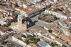
Tarazona de la Mancha is a municipality in the province of Albacete in the Autonomous community of Castile-La Mancha, Spain. It had a population of 6,647 at the 2011 census.

Campillo de Altobuey municipality of Spain

Campillo de Altobuey is a municipality in Cuenca, Castile-La Mancha, Spain. It has a population of 1,691.

Aras de los Olmos Municipality in Valencian Community, Spain

Aras de los Olmos is a municipality of Valencia, Spain. Belonging to the province of Valencia, in the region of Los Serranos.

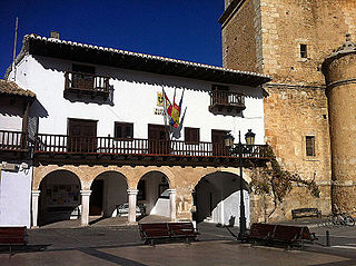
Villanueva de la Jara, popularly called La Jara, is a town and municipality in the Manchuela Conquense cormarca, this in turn is part of the La Manchuela comarca, province of Cuenca, in Castile-La Mancha, Spain. It is known for the cultivation of portobellos which is the main economic activity of the locality and other edible fungis.

Baños de Valdearados is a municipality and town located in the province of Burgos, Castile and León, Spain. According to the 2004 census (INE), the municipality has a population of 424 inhabitants.

Tosantos Municipality and town in Castile and León, Spain

Tosantos is a municipality and town located in the province of Burgos, Castile and León, Spain. According to the 2004 census (INE), the municipality has a population of 60 inhabitants. Tosantos is located on the Camino de Santiago de Compostela, a 1200-year-old pilgrimage route that runs through France and Northern Spain to the Spanish city of Santiago. The hamlet has a pilgrim hostel which is open from April through October and hosts up to 50 pilgrims a night.

Salinas del Manzano Place in Castile-La Mancha, Spain

Salinas del Manzano is a city of Spain in the province of Cuenca in the autonomous community of Castile-La Mancha. It has an area of 33.65 km2 with population of 105 inhabitants and a population density of 3.21 inhabitants / km2.

University of Castilla–La Mancha Spanish university

The University of Castilla–La Mancha (UCLM) is a Spanish university. It offers courses in the cities of Albacete, Ciudad Real, Cuenca, Toledo, Almadén and Talavera de la Reina. This university was recognised by law on 30 June 1982, and began to operate three years later.

Church of Nuestra Señora de la Esperanza cultural property in Peñas de San Pedro, Spain

The Church of Nuestra Señora de la Esperanza is an 18th-century, Roman Catholic parish church located in Peñas de San Pedro, province of Albacete, autonomous community of Castile-La Mancha, Spain.

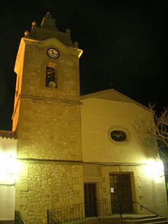
Santa Quiteria is a Neoclassic, Roman Catholic parish church in Higueruela, province of Albacete, Community of Castile-La Mancha, Spain.

References

  1. Municipal Register of Spain 2018. National Statistics Institute.