Felipe VI is King of Spain. In accordance with the Spanish Constitution, as monarch, he is head of state and commander-in-chief of the Spanish Armed Forces, holding the military rank of captain general, and also plays the role of the supreme representation of Spain in international relations.

Amadís de Gaula is an Iberian landmark work among the Spanish and Portuguese chivalric romances which were in vogue in the 16th century, although its first version, much revised before printing, was written at the onset of the 14th century in an uncertain place of the Iberian Peninsula.
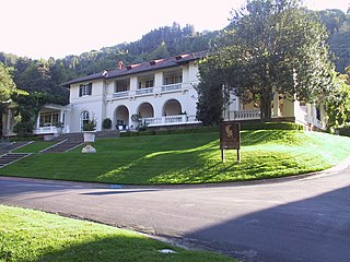
The Montalvo Arts Center is a non-profit center for the arts in Saratoga, California, United States. Open to the public, Montalvo comprises a cultural and arts center, a park, hiking trails and the historic Villa Montalvo, an Italian Mediterranean Revival mansion nestled in the foothills of the Santa Cruz Mountains. The mansion and estate were constructed from 1912 to 1914 by California statesman and businessman James Duval Phelan. After Phelan's death, the entire estate was donated to California as a park and then a cultural and arts center as it exists today. The arts center maintains the estate in partnership with Santa Clara County. The mansion is a historic landmark, and in 1978 it was awarded inclusion in the National Register of Historic Places.

Ambato is a city located in the central Andean valley of Ecuador. Lying on the banks of the Ambato River, the city also sits beneath several tall mountains. It is the capital city of the Tungurahua Province, situated at an elevation of 2,577 meters above sea level. It is variously nicknamed "City of Flowers and Fruits", "Land of the Three Juan's", and "Garden of Ecuador." Ambato's inhabitants are called Ambateños or Guaytambos. The current mayor of Ambato is Diana Caiza.

Leonor, Princess of Asturias is the heir presumptive to the Spanish throne. She is the elder daughter of King Felipe VI and Queen Letizia.
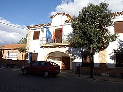
Paterna del Madera is a municipality in Albacete, Castile-La Mancha, Spain. It has a population of 351 people.
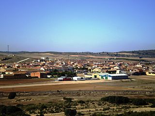
Pozo Cañada is a municipality in Albacete, Castile-La Mancha, Spain. It has a population of 2,703 as of 2023.

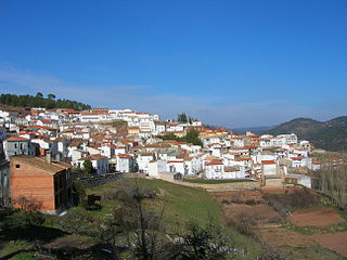
Pozohondo is a municipality in Albacete, Castile-La Mancha, Spain. It has a population of 1,551 as of 2023. It is located just about 30 minutes from the city of Albacete.
Miss Paraguay is a national beauty pageant in Paraguay established in 1915. It currently selects Paraguay's representatives for the Miss Intercontinental and Reinado Internacional del Café pageants.
Campamento de Verano was a Spanish reality-show airing on Telecinco. It started airing on 16 July 2013. The camp was situated on Sierra de Gredos. The final was on 9 September with model José Manuel Montalvo as the winner of the format.

Arnoldo Sergio Santaella Sendel is a Mexican actor, known for playing antagonistic roles in Mexican telenovelas.
Águila Roja is a Spanish adventure television series set in Spain during the 17th century. It was produced by Globomedia for Televisión Española and was broadcast on La 1 of Televisión Española from 2009 to 2016. It is one of the channel's most successful shows, and its rights have been sold to several countries.

Entre tu amor y mi amor is a Venezuelan telenovela written by Carlos Pérez for Venevisión. It premiered on June 15, 2016, with the final episode airing on November 28, 2016.

Acapulco, cuerpo y alma, is a Mexican telenovela produced by José Alberto Castro in 1995 for Televisa. It is a remake of the Mexican telenovela produced by Televisa in 1985, Tú o nadie.
Óscar Montalvo Finetti was a Peruvian football player, who played as a midfielder or as a winger. He died on November 2006, at the age of 69.

The Chair of RTVE, officially Chair of the Spanish Radio and Television Corporation, is the head of the RTVE Corporation and of the RTVE Board. The chair of RTVE is the chief executive of the corporation and chairs the Board, convene its meetings and execute its guidelines. The chair is appointed by the majority of the Congress of Deputies.

Pago Los Cerrillos is a branch of Montalvo Wilmot Wineries, a Spanish winery in Castilla–La Mancha, Spain. The Pago Los Cerrillos branch uses the Vino de Pago wine appellation, a classification for Spanish wine applied to individual vineyards or wine estates, unlike the Denominación de Origen Protegida (DOP) or Denominación de Origen Calificada (DOCa) which is applied to an entire wine region. The Pago Los Cerrillos was formed as a Vino de Pago in 2019, and geographically it lies within the extent of the La Mancha DOP appellation. The Montalvo Wilmot Wineries also produce Spanish wines under the Vino de la Tierra de Castilla (IGP) appellation.
The Vineyard is a Spanish romantic drama television limited series produced by Atresmedia Studios and Boomerang TV for Amazon Prime Video starring Leonor Watling, Rafael Novoa, Emilio Gutiérrez Caba and Juana Acosta. It is an adaptation of the novel of the same name by María Dueñas. It was released on 26 March 2021.

The Doctor Juan Abarca International Award in Medical Sciences, known as the Abarca Prize, is an award that recognises research and innovation through a biomedical finding of global significance.

Corazón guerrero is a Mexican telenovela that aired on Las Estrellas from 28 March 2022 to 9 September 2022. The series is produced by Salvador Mejía for TelevisaUnivision. It is an adaptation of the Argentine telenovela Valientes, and stars Alejandra Espinoza and Gonzalo García Vivanco.