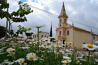
Armazém is a municipality in the Brazilian state of Santa Catarina. Is located at latitude 28º15'43" south and longitude 49º01'03" west, with an elevation of 30 meters. The city's streets are embellished with manicured gardens. Armazém has an area of 138.6 km ² and was emancipated from the city of Tubarão on December 19, 1958.

Caculé is a Brazilian municipality located in the state of Bahia, which possesses 23,291 inhabitants as of 2020, according to IBGE. It is situated 750 kilometers southwest from Salvador. Its economy is based mostly on agriculture. The climate in Caculé is warm and dry during the day, being cooler at night, at about 15 °C. The "Rio Antônio" crosses the city. Although it presently has no operational railroad station, Caculé is midpoint on the Ferrovia Centro Atlântica railroad route connecting Montes Claros to Salvador, Bahia.
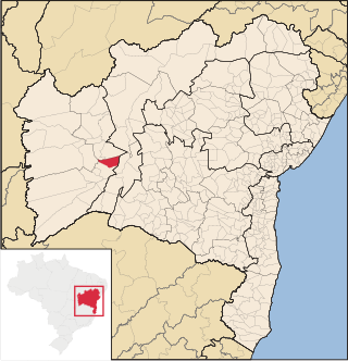
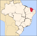
Serra Dourada is a municipality in the Brazilian state of Bahia. In 2020, the estimated population was 17,321.

Caldeirão Grande is a Brazilian municipality in the state of Bahia. Its estimated population as of 2020 was 13,391 inhabitants, up from 12,491 in 2010. It has an area of 458.31 square kilometres (176.95 sq mi). As of 2020, the mayor was Candido Pereira da Guirra Filho.
Morro do Chapéu is a municipality in the Brazilian state of Bahia, 386 km northwest of its capital, Salvador, 1012 meters above the sea level, because of which it is one of the coolest towns in Bahia, with temperatures occasionally falling below 10 °C in the winter. Its estimated population in 2020 is 35,440.
Viçosa is a Brazilian municipality in Alagoas state. Located inland on the zone of a former portion of the Atlantic Rain Forest, it is 86 km away from the state capital Maceió. Its population was 25,693 (2020) and its area is 354.76 km2.

Bujari is a municipality located in the northeast of the Brazilian state of Acre. The estimated population in 2020 is 10,420.

Craíbas is a municipality located in the western of the Brazilian state of Alagoas. Its population is 24,309 (2020) and its area is 275 km².

Feira Grande is a municipality located in the western region of the Brazilian state of Alagoas. Its population is 22,178 (2020) and its area is 156 square kilometres (60 sq mi).

Girau do Ponciano is a municipality located in the west of the Brazilian state of Alagoas. Its population is 41,237 (2020) and its area is 502 km².

Joaquim Gomes is a municipality located in Alagoas, Brazil. It had a population of 24,081 as of 2020, and an area of 239 km².

Paulo Jacinto is a municipality located in the center of the Brazilian state of Alagoas. Its population is 7,560 (2020) and its area is 108 km².

Tanque d'Arca is a municipality located in the center of the Brazilian state of Alagoas. In 2020, its population was 6,138. Its area is 156 km².

Santa Rita de Cássia is a Brazilian municipality in the state of Bahia. In 2020 the town's population was estimated as 28,481 inhabitants.

Serra Preta is a city located in the eastern state of Bahia, Brazil. The population in this arid region is 14,699. Serra Preta is about 150 miles northwest from Bahia's capital, Salvador, and 600 miles north of Rio de Janeiro.

Serrinha is a city in the state of Bahia, in eastern Brazil.

Candeias is a municipality in Brazil, in the state of Bahia. It is located 46 kilometres (29 mi) to the north of Salvador, the capital of Bahia. The town is near the BR-324 motorway. The town has a current population of 87,458.
Brejinho is a city in the state of Pernambuco, Brazil. The population in 2020, according to IBGE was 7,488 and the area is 106.3 km2.

Calumbi is a city in the state of Pernambuco, Brazil. The population in 2020, according to the IBGE, was 5,747 inhabitants. The total area is 179.31 km2.

Camocim de São Félix is a city located in the state of Pernambuco, Brazil. It is located 113.7 km away from Recife, the capital of Pernambuco. As of 2020, it has an estimated population of 18,900 inhabitants.