Fortaleza is the state capital of Ceará, located in Northeastern Brazil. It belongs to the Metropolitan mesoregion of Fortaleza and microregion of Fortaleza. It is Brazil's 5th largest city and the twelfth richest city in the country in GDP. It also has the third richest metropolitan area in the North and Northeast regions. It is an important industrial and commercial center of Brazil, the nation's eighth largest municipality in purchasing power. According to the Ministry of Tourism, the city reached the mark of second most desired destination of Brazil and fourth among Brazilian cities in tourists received. The BR-116, the most important highway of the country, starts in Fortaleza. The municipality is part of the Common Market of Mercosur Cities, and also the Brazilian state capital which is closest to Europe, 5,608 kilometres (3,485 mi) from Lisbon, Portugal.

Freguesia, usually translated as "parish" or "civil parish", is the third-level administrative subdivision of Portugal, as defined by the 1976 Constitution. It is also the designation for local government jurisdictions in the former Portuguese overseas territories of Cape Verde and Macau. In the past, was also an administrative division of the other Portuguese overseas territories. The parroquia in the Spanish autonomous communities of Galicia and Asturias is similar to a freguesia.

Angra do Heroísmo, or simply Angra, is a city and municipality on Terceira Island, Portugal, and one of the three capital cities of the Azores. Founded in 1478, Angra was historically the most important city in the Azores, as seat of the Bishop of the Azores, government entities, and having previously served as the capital city of Portugal during the Liberal Wars. The population in 2011 was 35,402, in an area of 239.00 km². It was classified as a World Heritage site by UNESCO in 1983.

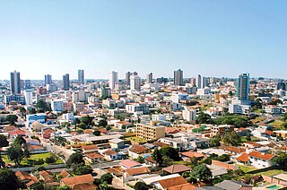
Cascavel is a city of Paraná state, Brazil. Is the fifth most populous city in Paraná with, with 332 333 residents, according IBGE, a government agency. The distance to Curitiba, the state capital, is 491 kilometers by freeway.

Santo Antão is the westernmost island of Cape Verde. At 785 km2 (303 sq mi), it is the largest of the Barlavento Islands group, and the second largest island of Cape Verde. The nearest island is São Vicente to the southeast, separated by the sea channel Canal de São Vicente. Its population was 38,200 in mid 2019, making it the fourth most populous island of Cape Verde after Santiago, São Vicente and Sal. Its largest city is Porto Novo located on the southern coast.

Panela or rapadura is an unrefined whole cane sugar, typical of Central and Latin America. It is a solid form of sucrose derived from the boiling and evaporation of sugarcane juice. Panela is known by other names in Latin America, such as chancaca in Chile and Peru, piloncillo in Mexico. The name piloncillo means little loaf, because of the traditional shape in which this smoky, caramelly and earthy sugar is produced. It has far more flavor than brown sugar, which is generally just white sugar with a small amount of molasses added back to it. Just like brown sugar, there are two varieties of piloncillo; one is lighter (blanco) and one darker (oscuro). Unrefined, it is commonly used in Mexico, where it has been around for at least 500 years. Made from crushed sugar cane, the juice is collected, boiled and poured into molds, where it hardens into blocks. Panela is also known as rapadura in Portuguese. Elsewhere in the world, the word jaggery describes a similar foodstuff. Both of them are considered non-centrifugal cane sugars.

Bom Jardim de Minas is a city of the state of Minas Gerais, Brazil.

Jaranwala is a city and capital of Jaranwala Tehsil located in the Faisalabad District of Punjab, Pakistan. It is the 58th largest city of Pakistan. It also one of the biggest Tahseel of Punjab by population of Pakistan.
Guarapuava is a city in the mid south of Paraná state in Brazil. It is the largest municipality in that state by area.

Ponta do Sol is the northernmost city on the island of Santo Antão and Cape Verde. It is situated on the coast, 4 km northwest of Ribeira Grande and 20 km north of the island capital Porto Novo. It is the seat of Ribeira Grande municipality.

Guaratuba is a city in the state of Paraná, Brazil. Founded on 1765, it is considered to be one of the most beautiful beaches of Paraná.
Praia is a concelho (municipality) of Cape Verde. It is situated in the southern part of the island of Santiago. Its seat is the city Praia, the capital of Cape Verde. Its area is 120.6 km2 (46.6 sq mi), and its population was 131,719 at the 2010 census. The municipality consists of one freguesia, Nossa Senhora da Graça. The city hall is located in the Platô part of the city.
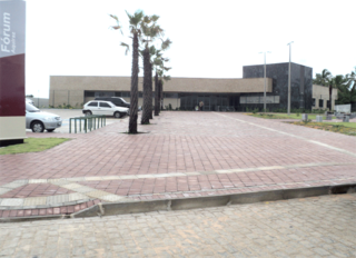
Aquiraz is the thirteenth largest city in the state of Ceará and is located on the nation's northeast coast. The municipality has a population of 80,935 with a population density of 150 inhabitants per square kilometer. Aquiraz is located 32 km (20 mi) from the state capital of Ceará, Fortaleza. It borders the municipalities of Maranguape, Caucaia, Pacatuba, Guaiuba, and Maracanau; the Atlantic Ocean makes up its northeast border. The Pacoti and Catu rivers cross Aquiraz and empty into the ocean.

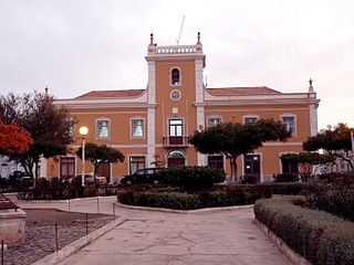
Casével is a former civil parish in the municipality of Castro Verde, Portugal. In 2013, the parish merged into the new parish Castro Verde e Casével. It is located 10 kilometres north-west of the municipal seat. It was considered the civil parish with the smallest population in the municipality, covering an area of approximately 33.3 km².

Uruburetama is a municipality in the state of Ceará in the Northeast region of Brazil. Its population, according to the census of the Brazilian Institute of Geography and Statistics, IBGE, 2010, is 19,765 people.

Tauá is a municipality in the state of Ceará in the Northeast region of Brazil. In 2020 it had an estimated population of 59,062 people. It is one of the largest municipalities in the state, with an area of 4,018.188 square kilometres (1,551.431 sq mi).

Barbalha is a municipality in the state of Ceará in the Northeast region of Brazil. Barbalha covers 569.5 km2 (219.9 sq mi), and has a population of 61,228 with a population density of 100 inhabitants per square kilometer. It is located at the south of the state, 575 km (357 mi) from the state capital of Fortaleza. The eastern part of the Araripe-Apodi National Forest, established in 1946, is located in Barbalha. The city sits at the foot of the Chapada do Araripe, a large plateau on the border of Ceará and Pernambuco.

The District of Porto is located on the north-west coast of Portugal. The district capital is the city of Porto, the second largest city in the country. It is bordered by the Aveiro and Viseu districts to the south, Braga district to the north and Vila Real district to the east.

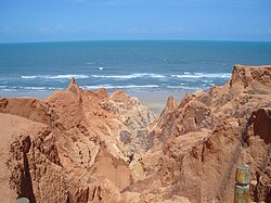
Beberibe Cliffs Natural Monument (Portuguese: Monumento Natural das Falésias de Beberibe is a natural monument in the state of Ceará, Brazil.

The Prainha do Canto Verde Extractive Reserve is a marine extractive reserve in the state of Ceará, Brazil.