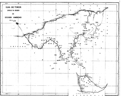
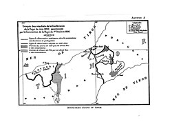
Native name: Pulau Batek Fatu Sinai | |
---|---|
Location in Timor | |
Geography | |
Location | Savu Sea |
Coordinates | 9°15′24″S123°59′35″E / 9.25667°S 123.99306°E |
Area | 0.135 sq mi (0.35 km2) |
Length | 500 m (1600 ft) |
Width | 320 m (1050 ft) |
Highest elevation | 50 m (160 ft) |
Administration | |
Province | East Nusa Tenggara |
Regency | Kupang Regency |
District | East Amfoang |
Batek Island (indonesian: Pulau Batek) or Fatu Sinai is a small island located in East Nusa Tenggara Province (NTT), Indonesia. [1] This island located in the Savu Sea, northwest of the island of Timor, 9.3 km (5.8 mi) off the East Timorese municipality of Oecusse.
The island is uninhabited, but is traditionally considered sacred by the local population on both sides of the border, even though the majority are now Christians. It is therefore referred to as Fatu Lulik (sacred mountain) or adat. Legend has it that the island came to its present position from Timor's interior. While the inhabitants of Nitibe see its origin in the East Timorese Oesilo, the people from East Amfoang assign the island's origin to the Indonesian Mount Mutis, the highest mountain in West Timor. The legends are similar because despite the border dating back to colonial times, the inhabitants of the region on both sides of the border belong to the Atoin Meto ethnic group.
The border treaties between Portugal and the Netherlands in 1859, 1896, 1904 and 1914 established the border between the two colonial powers' dominions on the island of Timor. Out of the four treaties, only the 1904 treaty mentions the island as Pulau Batek, where it is divided between Portuguese (Portuguese Timor) and the Dutch (Dutch East Indies). Later, Batek Island was a "forgotten island" that the colonial powers did not care about any further. After the Indonesian invasion of East Timor in 1975, the island was solely under Indonesian administration.
East Timor is claiming the island, using a map of 1914 as reference. In 2004, Indonesian Colonel Moesanip said that this claim was abandoned when the East Timorese Minister of Foreign Affairs, José Ramos-Horta, recognized Indonesian sovereignty over the island. [2] The Batek Island dispute between Indonesia and East Timor has largely been ended in 2005. [3] However, East Timorese chief negotiator Xanana Gusmão indicated in 2022 that negotiations were continuing. [4]
After the 1999 independence referendum, in which East Timor opted for a state independent of Indonesia and later placed under UN administration, Batek Island became a point of contention. In the first drafts of the Constitutional Commission of Oecussi Enclave, Batek Island was defined as part of Oe-Cusse Ambeno and thus as part of East Timorese territory, based on several consultations with the communities. However, the Constitution of East Timor did not list Batek Island as part of the national territory.
In the second half of 2002, Indonesia built a small lighthouse on Batek Island. On 14 December 2003, the Indonesian military conducted a military exercise in which a warship, helicopters and jet fighters used the island for several hours as part of the exercise. The inhabitants of Citrana, on the coast of Nitibe, felt threatened by this, especially as East Timor had not been informed of the manoeuvre beforehand. Publicly, the East Timorese government and the United Nations were reluctant to comment, and it was not until 12 January 2004 that the Australian press reported on the incident. On 16 January, Timor Leste has sent a memorandum of objection to Indonesia regarding the conduct of war exercises around Batek Island. [5] On 5 February, Indonesian Colonel Moesanip, KOREM commander of Kupang, stated that the manoeuvre was to demonstrate Indonesian sovereignty over Batek Island and that if East Timor resisted, Indonesia would station soldiers on the island.
On 2 March 2017, President Joko Widodo designated Batek Island as part of Indonesia's 111 outermost small islands. This designation status is stated in Presidential Decree No. 6/2017 on the Designation of Outermost Small Islands. [6]
Batek Island is a small island located in East Amfoang District, Kupang Regency, East Nusa Tenggara (NTT). This island is located near the border between Indonesia and Timor Leste, right in the Savu Sea. Geographically, Batek Island has a relatively small area and is surrounded by the vast waters of the Savu Sea.
This island has unique natural characteristics with a coast filled with coral rocks and dense coastal vegetation. This area tends to have a dry tropical climate, which is a common characteristic in the Nusa Tenggara region (Lesser Sunda Islands), with varying rainfall and a longer dry season than the rainy season. [7]
Administratively, Batek Island is included in the East Amfoang district, which is one of the districts in Kupang Regency. East Amfoang district itself mostly consists of coastal areas that directly border Timor Leste. Access to the island is relatively difficult due to its remote location, and most of the population living in this area depend on fishing and subsistence farming for their livelihoods.
Batek Island also has strategic value due to its location near the border, so it is often a concern in the context of monitoring the border area between Indonesia and Timor Leste. [8]
Timor is an island at the southern end of Maritime Southeast Asia, in the north of the Timor Sea. The island is divided between the sovereign states of East Timor in the eastern part and Indonesia in the western part. The Indonesian part, known as West Timor, constitutes part of the province of East Nusa Tenggara. Within West Timor lies an exclave of East Timor called Oecusse District. The island covers an area of 30,777 square kilometres. The name is a variant of timur, Malay for "east"; it is so called because it lies at the eastern end of the Lesser Sunda Islands. Mainland Australia is less than 500 km away, separated by the Timor Sea.
West Timor is an area covering the western part of the island of Timor, except for the district of Oecussi-Ambeno. Administratively, West Timor is part of East Nusa Tenggara Province, Indonesia. The capital as well as its main port is Kupang. During the colonial period, the area was named Dutch Timor and was a centre of Dutch loyalists during the Indonesian National Revolution (1945–1949). From 1949 to 1975 it was named Indonesian Timor.
East Nusa Tenggara is the southernmost province of Indonesia. It comprises the eastern portion of the Lesser Sunda Islands, facing the Indian Ocean in the south and the Flores Sea in the north. It consists of more than 500 islands, with the largest ones being Sumba, Flores, and the western part of Timor; the latter shares a land border with the separate nation of East Timor. The province is subdivided into twenty-one regencies and the regency-level city of Kupang, which is the capital and largest city.
Rote Island is an island of Indonesia, part of the East Nusa Tenggara province of the Lesser Sunda Islands. According to legend, this island got its name accidentally when a lost Portuguese sailor arrived and asked a farmer where he was. The surprised farmer, who could not speak Portuguese, introduced himself, "Rote".
Kupang, formerly known as Koepang or Coupang, is the capital of the Indonesian province of East Nusa Tenggara. At the 2020 Census, it had a population of 442,758; the official estimate as of mid-2023 was 444,661. It is the largest city and port on the island of Timor, and is a part of the Timor Leste–Indonesia–Australia Growth Triangle free trade zone. Geographically, Kupang is the southernmost city in Indonesia.
Ombai Strait is an international strait in Southeast Asia. It separates the Alor Archipelago from the islands of Wetar, Atauro, and Timor in the Lesser Sunda Islands. The strait is also the western portion of a pair of international straits, the other one being Wetar Strait; the two straits combine to link the Pacific Ocean with the Indian Ocean.
Savu is the largest of a group of three islands, situated midway between Sumba and Rote, west of Timor, in Indonesia's eastern province, East Nusa Tenggara. Ferries connect the islands to Waingapu on Sumba, Ende on Flores, and Kupang in West Timor. Flying to Savu through Susi Air from Kupang, Ende, and Waingapu is also possible.
The Tono River is the principal river of Oecusse, an exclave of East Timor. The river and its major tributaries flow generally north, through the centre of the exclave, into the Savu Sea, reaching the sea near Lifau. Its alluvial flood plain in Pante Macassar administrative post is the main rice-producing place in Oecusse.
The Noel Besi River is a river flowing in the west part of Timor island and forms part of the border between the East Timor exclave of Oecussi and Indonesian West Timor. It flows north into the Sawu Sea. Located 1900 km east of the Indonesian capital, Jakarta.
East Timor and Indonesia established diplomatic relations in 2002. Both share the island of Timor. Indonesia invaded the former Portuguese colony in 1975 and annexed East Timor in 1976, maintaining East Timor as its 27th province until a United Nations-sponsored referendum in 1999, in which the people of East Timor chose independence. Following a United Nations interim administration, East Timor gained independence in 2002. Indonesia already had a consulate in Dili during the Portuguese colonial period, though Indonesia formalized their relations by establishing an embassy in Dili. Since October 2002, East Timor has an embassy in Jakarta and consulates in Denpasar and Kupang. Relations between the two countries are generally considered highly positive, despite various problems. Numerous agreements regulate cooperation in different areas. East Timorese are visa-free in Indonesia.
North Central Timor Regency is a regency in East Nusa Tenggara Province, Indonesia. It covers an area of 2,674.02 km2, and had a population of 229,803 at the 2010 Census and 259,829 at the 2020 Census; the official estimate as at mid 2023 was 269,628. Its regency seat is located at the town of Kefamenanu, which had a population of 47,628 in mid 2023. The regency borders Timor Leste's Oecusse enclave, one of few Indonesian regions that have a land border with other countries.
Kodam IX/Udayana is a military regional command of the Indonesian Army which is responsible for the Lesser Sunda Islands. It was established as part of the 1985 reorganisation of the Indonesian National Armed Forces (TNI) and included East Timor until that province achieved independence in 1999.
Oecusse, also known as Oecusse-Ambeno and formerly just Ambeno, officially the Special Administrative Region Oecusse-Ambeno, is an exclave, municipality and the only special administrative region (SAR) of East Timor.
The Lesser Sunda Islands, now known as Nusa Tenggara Islands, are an archipelago in Indonesian archipelago. Most of the Lesser Sunda Islands are located within the Wallacea region, except for the Bali province which is west of the Wallace Line and is within the Sunda Shelf. Together with the Greater Sunda Islands to the west, they make up the Sunda Islands. The islands are part of a volcanic arc, the Sunda Arc, formed by subduction along the Sunda Trench in the Java Sea. In 1930 the population was 3,460,059; today slightly over 15.5 million people live on the islands. Etymologically, Nusa Tenggara means "Southeast Islands" from the words of nusa which means 'island' from Old Javanese language and tenggara means 'southeast'.
The East Timor–Indonesia border is the international border between East Timor and Indonesia. The border consists of two non-contiguous sections totalling 253 km in length, the larger section of which divides the island of Timor in two. The demarcation of the border between Indonesia and East Timor has been fought over by various parties for 350 years. The first attempts to define it precisely were made by the colonial powers of the Netherlands and Portugal with the Treaty of Lisbon in 1859, but it was not until the Permanent Court of Arbitration's award of 25 June 1914 that the final land border between them on the island of Timor was established. It largely coincides with today's border between the state of East Timor (Timor-Leste), which only gained its final independence in 2002, and West Timor, which belongs to Indonesia, but was still disputed on some points until 2019.
Batugade is a suco (village) located in Balibó Subdistrict, Bobonaro Municipality of East Timor. The administrative seat of the suco is the village of Batugade.
Sacato, sometimes spelled Sakato, is a village in East Timor. It is located in the suco of Nipane within the Pante Macassar Administrative Post in the Oecusse Special Administrative Region. It also the main border crossing between the East Timorese exclave of Oecusse and Indonesia.
Cornelis Feoh was an Indonesian politician and member of the Golkar Party of East Nusa Tenggara. Feoh, who was from Rote Island in Rote Ndao Regency, served in the East Nusa Tenggara Regional People's Representative Council (DPRD) from 2019 until his death in office on January 3, 2021.
Severe Tropical Cyclone Seroja was the third-deadliest tropical cyclone on record in the Australian region, behind Cyclone Mahina in 1899 and the Flores cyclone in 1973. Seroja brought historic flooding and landslides to portions of southern Indonesia and East Timor and later went on to make landfall in Western Australia's Mid West region, becoming the first to do so since Cyclone Elaine in 1999. The twenty-second tropical low, seventh tropical cyclone, and third severe tropical cyclone of the 2020–21 Australian region cyclone season, the precursor of Seroja formed off the south coast of Timor island as Tropical Low 22U at 18:00 UTC on 3 April 2021; its genesis was related to convectively coupled equatorial waves. The tropical low moved very slowly near the island, while the system's thunderstorms increased in organization. The low intensified into Tropical Cyclone Seroja by 4 April, while it was passing north of Rote Island, while continuing its slow strengthening trend.
Mutis is a district (kecamatan) located in North Central Timor Regency, East Nusa Tenggara, Indonesia.