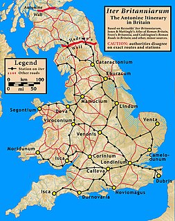
There are many Roman sites in Great Britain that are open to the public. There are also many sites that do not require special access, including Roman roads, and sites that have not been uncovered.

Hope is a village and civil parish in the Derbyshire Peak District, in England. The population at the 2011 Census was 864. It lies in the Hope Valley, at the point where Peakshole Water flows into the River Noe. To the north, Win Hill and Lose Hill stand either side of the Noe.

The Hope Valley is a rural area centred on the village of Hope, Derbyshire, in the Peak District in the northern Midlands of England.

The history of Derbyshire can be traced back to human settlement since the last Ice Age, over 10,000 years ago. The county of Derbyshire in England dates back to the 11th century.

Templeborough is a suburb of Rotherham, South Yorkshire, England. The suburb falls within the Brinsworth and Catcliffe ward of Rotherham Metropolitan Borough Council. The area takes its name from the remains of the Roman fort found there which were mistakenly believed to be that of a Roman Temple.

Brough and Shatton is a civil parish in Hope Valley in the High Peak district of Derbyshire, England. It is named for the two hamlets of Brough-on-Noe and Shatton. Brough is about 2 km, or just over 1 mile, west (upstream) of Shatton; both are on the River Noe, a tributary of the upper River Derwent. They lie within the Peak District National Park, about 15 miles west of Sheffield and 30 miles east of Manchester. According to the 2011 census, Brough and Shatton had a combined population of 136. There is a friendly rivalry between the two hamlets, which contest numerous sports competitions throughout the year.

Aquae Arnemetiae was a small town in the Roman province of Britannia. The settlement was based around its natural warm springs. Today it is the town of Buxton, Derbyshire in England.

The Limb Brook is a stream in Sheffield, South Yorkshire, England. It rises at the village of Ringinglow, flowing east through Whirlow and Ecclesall Woods into Abbeydale in the Beauchief area, where it merges with the River Sheaf. Near this point part of the stream has been diverted to provide the goit for the Abbeydale Industrial Hamlet millpond, and this channel flows through what is now Beauchief Gardens.

Bradwell is a village and civil parish in the Derbyshire Peak District of England. The population of the civil parish taken at the 2011 Census was 1,416. It lies south of the main body of the Hope Valley but is usually included among its settlements.

Stanedge Pole also known as Stanage Pole is a landmark on Hallam Moors close to Stanage Edge in South Yorkshire, England. Standing at a height of 438 metres, it marks the border between Derbyshire and South Yorkshire and can be seen for several miles around.
The Sheffield to Hathersage turnpike was an early road through the English Peak District, which was improved by a turnpike trust in the 18th century. The road may have originated as a Roman road.
The Street is the medieval name of the Roman road that ran across the high limestone plateau of central Derbyshire from the spa town of Buxton southeast towards modern Derby. The line of the road can be traced from surviving features, confirmed by archaeology, from Buxton as far as Longcliffe just north of Brassington. It is believed that from Brassington the road ran eastwards to Wirksworth and there joined another road which crossed the Derwent at Milford and ran on the east bank of the Derwent and can be traced to the northern suburbs of Derby to Little Chester, the site of the Roman settlement of Derventio. The 1723 map of Brassington Moor shows The Street road from Buxton through Pikehall up to the Upper Harborough Field Gate, leading onto Manystones Lane & Brassington Lane towards Wirksworth. In records from 1613 the road from Brassington to Wirksworth is called 'Highe Streete'.

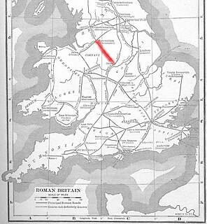
Long Causeway or Long Causey was a Medieval packhorse route in England, which ran between Sheffield in South Yorkshire and Hathersage in Derbyshire. In the past the route has been marked on maps as a Roman Road as it was believed it followed part of the route of Batham Gate between Templeborough and Buxton, although in recent years some scholars have cast doubt on this.

Navio Roman fort overlooks a tight bend of the River Noe at Brough-on-Noe near Hope, Derbyshire, in England. Navio fort and vicus is a Scheduled Monument.
Hay Dale is a short dry valley near Buxton, Derbyshire, in the Peak District of England. It is part of a longer valley that runs for approximately 4 miles (6.4 km) north–south from Peak Forest to the River Wye at Millers Dale. This valley has several names along its length: from the northern end running downhill these are Dam Dale, Hay Dale, Peter Dale and Monk's Dale. There is a farmland plateau on either side.

Peter Dale is a short dry crag-sided valley near Buxton, Derbyshire, in the Peak District of England. There is a farmland plateau on either side. The northern end of the valley leads into Hay Dale at Dale Head and the foot of the valley leads into Monk's Dale. Hay Dale and Monk's Dale are both part of the Derbyshire Dales National Nature Reserve managed by Natural England. The Carboniferous limestone rocks of all these dales were formed 350 million years ago from the shells and sediments of a tropical sea. The landscape was then sculpted by the ice sheets from the last Ice Age 20,000 years ago.

Lutudarum was a town in the Roman province of Britannia, in the area that is now mid-Derbyshire. The settlement is believed to have been at either Wirksworth or nearby Carsington, although Matlock and Cromford are other candidates. The town was recorded as Lutudaron between Derventio and Veratino (Rocester) in the Ravenna Cosmography's list of all known places in the world in about 700 AD.

Doctor's Gate is a Roman road in the Derbyshire Peak District of England, which ran between Melandra fort at Glossop and Navio fort at Brough-on-Noe. Doctor's Gate was recorded in 1627 as "Docto Talbotes Gate", named after Dr John Talbot who is attributed with improving the summit section in the late 15th century and 'gate' is derived from the Scandinavian word for road.

Bradwell Moor is a moorland hill above the village of Bradwell, Derbyshire in the Peak District. The summit is 471 metres (1,545 ft) above sea level.

The Vale of Edale is the upper valley of the River Noe, in the Derbyshire Peak District of England. The village of Edale lies in the middle of the valley.


