
Clearwater is a district municipality in the North Thompson River valley in British Columbia, Canada, where the Clearwater River empties into the North Thompson River. It is located 124 km (77 mi) north of Kamloops. The District of Clearwater was established on December 3, 2007, making it one of the newest municipalities in British Columbia. It is near Wells Gray Provincial Park and is surrounded by the Trophy Mountains, Raft Mountain and Dunn Peak.

Caligata Lake Provincial Park is a provincial park in British Columbia, Canada, located northeast of Clearwater. The lake occupies a cirque below the north face of Raft Mountain. The park has no visitor facilities or services.

The Clearwater River is the largest tributary of the North Thompson River, joining it at the community of Clearwater, British Columbia. The Clearwater rises from glaciers in the Cariboo Mountains and flows in a mostly southerly direction for 201 km (125 mi) to the North Thompson. Its entire course, except the last 5 km (3 mi), is within Wells Gray Provincial Park. Its confluence with the North Thompson is protected by North Thompson River Provincial Park.
Buck Hill is a hill in east-central British Columbia, Canada, located 17 km (10.6 mi) north of Clearwater. It rises from the west slope of Trophy Mountain. Buck Hill is just outside the boundary of Wells Gray Provincial Park.

Canim Lake is a lake in British Columbia, Canada. Its west end is 36 km (22.4 mi) northeast of 100 Mile House. "Canim" means a type of large canoe in the Chinook Jargon. Canim Lake is 26.5 km (16.5 mi) long. It is also part of the territory of the Shuswap First Nation where the ancestors are part of the Lake Division of the Shuswap nation of the Interior Nations of British Columbia. The Reilly Commission states that the 2,029 hectares region around Canim Lake are set aside for the Shuswap First Nation. In the summer of 1995, there was an archaeological evidence of an ancient civilization and evidence of carbon dated as 4,300 old.

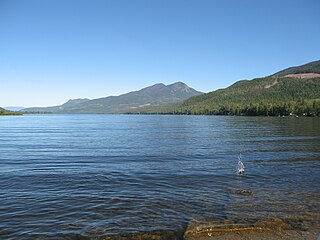
Clearwater Lake is one of six large lakes in Wells Gray Provincial Park in east-central British Columbia, Canada,. The Clearwater River enters the lake at its north end, flowing from Hobson Lake and Azure Lake, and also drains the lake. There are several small streams that flow into Clearwater Lake, but it has no significant tributaries.
Mahood Lake is a lake in the South Cariboo region of the Interior of British Columbia in Wells Gray Provincial Park. It is drained by the Mahood River, a tributary of the Clearwater River which has cut a deep canyon into Cambrian rocks and Pleistocene glacial moraines. Mahood Lake is fed by the short Canim River, which drains nearby Canim Lake to the west via Canim Falls and Mahood Falls.

The Mahood River is a river in the northern Shuswap Highland of the Central Interior of British Columbia in Wells Gray Provincial Park. It is 7 kilometres (4.3 mi) long from its source at Mahood Lake to its confluence with the Clearwater River, a tributary of the North Thompson River. The Mahood River has cut a deep canyon into Cambrian rocks and Pleistocene glacial moraines.

Fiftytwo Ridge is a mountain ridge in east-central British Columbia, Canada, located just southwest of Battle Mountain at the southeastern end of Wells Gray Provincial Park.

The Wells Gray-Clearwater volcanic field, also called the Clearwater Cone Group, is a potentially active monogenetic volcanic field in east-central British Columbia, Canada, located approximately 130 km (81 mi) north of Kamloops. It is situated in the Cariboo Mountains of the Columbia Mountains and on the Quesnel and Shuswap Highlands. As a monogenetic volcanic field, it is a place with numerous small basaltic volcanoes and extensive lava flows.
The Skyline Trail is a hiking trail in Jasper National Park, Alberta, Canada. It is known for its views, with much of the hike being located above the tree line. It is also known for challenging weather conditions above the tree line, which can be a problem for hikers, who can lose sight of trails.

Azure Lake is a fjord-like lake located in east-central British Columbia, Canada. It is an expansion of the Azure River which rises from an unnamed glacier in the Cariboo Mountains. The outflow is also called the Azure River, but it is only 50 m (164 ft) long before it flows into the Clearwater River. Azure Lake is one of the six major lakes in Wells Gray Provincial Park.
Hobson Lake is the uppermost lake on the Clearwater River in east-central British Columbia, Canada. Hobson Lake is one of the six major lakes in Wells Gray Provincial Park.

Wells Gray Provincial Park is a large wilderness park located in east-central British Columbia, Canada. The park protects most of the southern, and highest, regions of the Cariboo Mountains and covers 5,415 square kilometres. It is British Columbia's fifth largest provincial park, after Tweedsmuir, Tatshenshini, Spatsizi and Northern Rocky Mountains.

Garnet Peak is a mountain in east-central British Columbia, Canada, located between Goat Creek and Azure Lake. Situated in the Cariboo Mountains of the Columbia Mountains, it is the third highest mountain in Wells Gray Provincial Park with an elevation of 2,876 m (9,436 ft). Garnet Peak is a prominent mountain as one drives the Clearwater Valley Road into Wells Gray Park and is first visible from 80 km (50 mi) south at the Clearwater Valley Overlook.

Mount Hugh Neave is a mountain in east-central British Columbia, Canada, located between Hobson Lake to the west and Goat Creek to the south. Situated in the Cariboo Mountains of the Columbia Mountains, it is the seventh highest mountain in Wells Gray Provincial Park with an elevation of 2,829 m (9,281 ft).

Trophy Mountain is a mountain in east-central British Columbia, Canada, located in the south-east region of Wells Gray Provincial Park. The Clearwater River flows to the west, Raft River to the east and Spahats Creek to the south. Trophy Mountain is part of the Shuswap Highland. There are nine summits in the group and the highest is 2,577 m (8,455 ft). Battle Mountain and Table Mountain are the closest summits to the north and Raft Mountain is immediately south. Trophy Mountain was given its name by Dan Case, a big-game hunting guide in the area.

South Chilcotin Mountains Provincial Park is a provincial park in British Columbia, Canada, located on Highway 40 northwest of Lillooet, British Columbia. The park, which is 56,796 ha. in size, was established on April 18, 2001, and It was created out of a portion of the Spruce Lake Protected Area. The park is located on three Indigenous Nations: The Tsilhqot’in, St’at’imc, and Secwepemc.

Raft Mountain is a mountain in east-central British Columbia, Canada, located north-east of Clearwater and just outside the south boundary of Wells Gray Provincial Park. The Clearwater River flows to the west, Raft River to the east, Spahats Creek to the north, and North Thompson River to the south. Raft Mountain is part of the Shuswap Highland. There are five summits in the group and the highest is 2,450 m (8,038 ft). Trophy Mountain is the closest summit to the north.

The Mount Adams Recreation Area is a 21,000-acre (8,500 ha) recreation area in the U.S. state of Washington managed by the Yakama Nation Tribal Forestry Program. The area encompasses an ecologically complex and geologically active landscape. The region features the most rugged side of Mount Adams, including canyons and the Great Gap section of the Mount Adams circumnavigation route, a three-mile trail-less section over two great canyons and many difficult glacial creeks. At 12,276 feet (3,742 m), Mount Adams is one of the major Cascade mountains. The recreation area is on the east side of the mountain and is part of the Yakama Indian Reservation and includes the popular Bird Creek Meadows area.


