
Mount Price is a small stratovolcano in the Garibaldi Ranges of the Pacific Ranges in southwestern British Columbia, Canada. It has an elevation of 2,049 metres and rises above the surrounding landscape on the western side of Garibaldi Lake in New Westminster Land District. The mountain contains a number of subfeatures, including Clinker Peak on its western flank, which was the source of two thick lava flows between 15,000 and 8,000 years ago that ponded against glacial ice. These lava flows are structurally unstable, having produced large landslides as recently as the 1850s. A large provincial park surrounds Mount Price and other volcanoes in its vicinity. It lies within an ecological region that surrounds much of the Pacific Ranges.

Pyramid Mountain is a subglacial mound located on the Murtle Plateau in Wells Gray Provincial Park, east-central British Columbia, Canada.
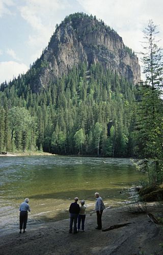
White Horse Bluff is a subaqueous volcano in Wells Gray Provincial Park, east-central British Columbia, Canada.

The Table, sometimes called Table Mountain, is a 2,021-metre (6,631 ft) high flow-dominated andesite tuya located 4 kilometres (2 mi) south of Garibaldi Lake, 15 kilometres (9 mi) northeast of Cheekye and 5 kilometres (3 mi) north of Mount Garibaldi, British Columbia, Canada. It rises over 530 metres (1,740 ft) above the surface of Garibaldi Lake, which lies less than 1 kilometre (1 mi) to the north.
Tuya Butte is a tuya in the Tuya Range of north-central British Columbia, Canada. It is a bit less isolated from other ranges than neighbouring Mount Josephine. Some of the other volcanoes in the area include South Tuya, Ash Mountain, and Mathews Tuya.

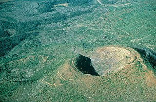
Kostal Cone, also called Kostal Volcano and Fire Mountain, is a young cinder cone in Wells Gray Provincial Park in east-central British Columbia, Canada. It rises from the northeast shore of Kostal Lake in the Cariboo Mountains. With an elevation of 1,440 m (4,724 ft), Kostal Cone is one of the lowest volcanoes in the Wells Gray-Clearwater volcanic field.

Mount Ray, also known as Ray Mountain, is a subglacial mound in Wells Gray Provincial Park, British Columbia, Canada. Mount Ray last erupted during the Pleistocene. It is part of the Wells Gray-Clearwater volcanic field.
Buck Hill is a hill in east-central British Columbia, Canada, located 17 km (10.6 mi) north of Clearwater. It rises from the west slope of Trophy Mountain. Buck Hill is just outside the boundary of Wells Gray Provincial Park.
The Flourmill Volcanoes, also known as The Flourmills, are a small volcano range near the west boundary of Wells Gray Provincial Park in east-central British Columbia, Canada. Located north of Mahood Lake and west of the Clearwater River, they form part of the Wells Gray-Clearwater volcanic field.
McLeod Hill is a tuya, located 41 km (25 mi) north of Clearwater in the Wells Gray-Clearwater volcanic field in Wells Gray Provincial Park, east-central British Columbia, Canada.

Volcanic activity is a major part of the geology of Canada and is characterized by many types of volcanic landform, including lava flows, volcanic plateaus, lava domes, cinder cones, stratovolcanoes, shield volcanoes, submarine volcanoes, calderas, diatremes, and maars, along with less common volcanic forms such as tuyas and subglacial mounds.

The geology of the Pacific Northwest includes the composition, structure, physical properties and the processes that shape the Pacific Northwest region of North America. The region is part of the Ring of Fire: the subduction of the Pacific and Farallon Plates under the North American Plate is responsible for many of the area's scenic features as well as some of its hazards, such as volcanoes, earthquakes, and landslides.

Catherine Hickson is a Canadian volcanologist, formerly with the Geological Survey of Canada, part of Natural Resources Canada. Since 2014, she has been the chief operating officer for Dajin Resources Corp. and president, Tuya Terra Geo Corp. Hickson studied at the University of British Columbia and received her PhD in geology and volcanology in 1987.

Clearwater Lake is one of six large lakes in Wells Gray Provincial Park in east-central British Columbia, Canada,. The Clearwater River enters the lake at its north end, flowing from Hobson Lake and Azure Lake, and also drains the lake. There are several small streams that flow into Clearwater Lake, but it has no significant tributaries.

Spahats Creek Falls, also called Spahats Falls, is a waterfall on Spahats Creek within Wells Gray Provincial Park of British Columbia, Canada. Common references place the falls at around 60 m (197 ft) tall, but taking into account the second tier, it is closer to 75–80 meters tall. It is a popular stop for tourists and especially motorcoach tours since it is only 10 km (6.2 mi) off the busy Yellowhead Highway.
Wetalth Ridge is an isolated ridge in northern British Columbia, Canada, located 74 km (46 mi) southwest of Tatogga and south of Telegraph Creek. It lies on the southwest side of Little Arctic Lake at the southwest corner of Mount Edziza Provincial Park.
The Wells Gray-Clearwater volcanic field, also called the Clearwater Cone Group, is a potentially active monogenetic volcanic field in east-central British Columbia, Canada, located approximately 130 km (81 mi) north of Kamloops. It is situated in the Cariboo Mountains of the Columbia Mountains and on the Quesnel and Shuswap Highlands. As a monogenetic volcanic field, it is a place with numerous small basaltic volcanoes and extensive lava flows.

The Mount Cayley volcanic field (MCVF) is a remote volcanic zone on the South Coast of British Columbia, Canada, stretching 31 km (19 mi) from the Pemberton Icefield to the Squamish River. It forms a segment of the Garibaldi Volcanic Belt, the Canadian portion of the Cascade Volcanic Arc, which extends from Northern California to southwestern British Columbia. Most of the MCVF volcanoes were formed during periods of volcanism under sheets of glacial ice throughout the last glacial period. These subglacial eruptions formed steep, flat-topped volcanoes and subglacial lava domes, most of which have been entirely exposed by deglaciation. However, at least two volcanoes predate the last glacial period and both are highly eroded. The field gets its name from Mount Cayley, a volcanic peak located at the southern end of the Powder Mountain Icefield. This icefield covers much of the central portion of the volcanic field and is one of the several glacial fields in the Pacific Ranges of the Coast Mountains.

Wells Gray Provincial Park is a large wilderness park located in east-central British Columbia, Canada. The park protects most of the southern, and highest, regions of the Cariboo Mountains and covers 5,415 square kilometres. It is British Columbia's fifth largest provincial park, after Tweedsmuir, Tatshenshini, Spatsizi and Northern Rocky Mountains.

Trophy Mountain is a mountain in east-central British Columbia, Canada, located in the south-east region of Wells Gray Provincial Park. The Clearwater River flows to the west, Raft River to the east and Spahats Creek to the south. Trophy Mountain is part of the Shuswap Highland. There are nine summits in the group and the highest is 2,577 m (8,455 ft). Battle Mountain and Table Mountain are the closest summits to the north and Raft Mountain is immediately south. Trophy Mountain was given its name by Dan Case, a big-game hunting guide in the area.
