Trophy Mountain

Last updated
Trophy Mountain
Trophy Mountain Wells Gray.jpg
Highest summit of Trophy Mountain seen from DeKelver Summit
Highest point
Elevation 2,577 m (8,455 ft) [1]
Prominence 1,467 m (4,813 ft) [1]
Listing Mountains of British Columbia
Coordinates 51°47′58″N119°52′32″W / 51.79944°N 119.87556°W / 51.79944; -119.87556 [2]
Geography
Canada British Columbia relief location map.jpg
Red triangle with thick white border.svg
Trophy Mountain
British Columbia, Canada
DistrictKamloops Division Yale Land District
Parent range Shuswap Highland
Monashee Mountains
Topo map NTS 82M13 West Raft River or PS-WG3 (south half)
Geology
Mountain type Pyramidal peak
Climbing
Easiest route Via DeKelver Summit and West Ridge

Trophy Mountain (locally called Trophy Mountains or The Trophies) is a mountain in east-central British Columbia, Canada, located in the south-east region of Wells Gray Provincial Park. The Clearwater River flows to the west, Raft River to the east and Spahats Creek to the south. Trophy Mountain is part of the Shuswap Highland. There are nine summits in the group and the highest is 2,577 m (8,455 ft). Battle Mountain and Table Mountain are the closest summits to the north and Raft Mountain is immediately south. [3] Trophy Mountain was given its name by Dan Case, a big-game hunting guide in the area. [4] :273

Contents

Trophy Mountain is easily accessible by road and trail. It is a popular summer tourist attraction and is especially noted for colourful alpine meadows. Several hiking trails and routes are available.

Access

Trophy Mountain Road turns east off Clearwater Valley Road (also called Wells Gray Park Road) 11.3 km (7.0 mi) north of the Yellowhead Highway. The gravel road is steep and rough, and usable by all vehicles except those with very low clearance. It is 13 km (8.1 mi) to the parking lot. [3]

A well-used trail starts here and climbs 300 m (984 ft) through a band of trees to the alpine meadows. The leisurely hike of 3.1 km (1.9 mi) takes about 75 minutes to reach an abandoned shepherd's hut. During the last 30 minutes, there are views of the north face of Raft Mountain across Spahats Creek Valley to the south. This section of the meadows has colourful flower displays in late July and early August, as well as an earlier bloom of glacier lilies in late June. The trail continues past the hut for 30 minutes to the Sheila Lake Lookout. This viewpoint encompasses Sheila Lake to the north, Plateau of Lakes with numerous tarns to the northeast, and four of the nine Trophy summits beyond that. Raft Mountain and the spire of Dunn Peak are to the south. [3] [5]

A few primitive campsites and an outhouse are located near Sheila Lake for the benefit of backpackers. Trails continue past Sheila Lake and the Lookout across the Plateau of Lakes. The hiking season on Trophy Mountain is from late June through September.

History

Trophy Flower Meadows in early August Trophy Flower Meadows.jpg
Trophy Flower Meadows in early August

The shepherd's hut was built by brothers John and Frank Ronacher in the 1950s when they herded sheep on the Trophy meadows. At that time, the access was via a rough trail up Third Canyon which the Ronachers widened with a bulldozer. Frank died in 1962 and later that year John sold the Trophy grazing lease and 100 ewes and rams to Emil and Ida DeKelver. They arrived in the Clearwater Valley in 1958 and settled on an 80-acre farm beside Candle Creek. At first, the DeKelvers raised dairy cattle then, after purchasing the Ronacher business, were busy with their sheep. Soon they had expanded the herd to 300 and were very successful with the lush Trophy grasslands. In 1969, mounting government pressure against grazing lease-holders persuaded the DeKelvers to switch to guiding and trail-riding on the Trophy Mountains. They built a new trail up Spahats Creek which was much shorter than the Third Canyon route, although strenuous compared to today's stroll to the meadows. When logging started on the Trophy Mountains in 1979 and roads were built almost to treeline, the DeKelvers’ business was ruined and they retired to their Candle Creek farm. Ida spent many years collecting historic artifacts from the Clearwater Valley and developing the Yellowhead Museum which is now closed. Meanwhile, high on Trophy Mountain, the shepherd's hut is being ravaged by the alpine weather and soon there will be no evidence of the days when these meadows were home to hundreds of sheep. [3]

DeKelver Summit is west of the highest summit and remembers Ida and Emil DeKelver. Ronacher Lake is west of Sheila Lake and refers to the Ronacher brothers. [3]

The south boundary of Wells Gray Park was originally established in 1939 through Grouse Creek Valley just north of Trophy Mountain. In 1997, the park was expanded to include the mountain above its treeline.

Geology

Most of the rock comprising Trophy Mountain is part of the ancient Shuswap Metamorphic Complex which arches across the British Columbia Interior in a wide band from Shuswap Lake to Adams Lake and into the Quesnel Highland. No age has been established, but it was intruded by the Raft Batholith about 100 million years ago. The glaciers of the Pleistocene and earlier ice ages have scoured Trophy Mountain creating numerous bowls now filled by lakes and the rugged north face which is 700 m (2,297 ft) high. [3] [5]

Much of the lava which accumulated in the Clearwater Valley near Spahats Creek was spewed out from fissures on the west side of Trophy Mountain between 500,000 and 300,000 years ago. Evidence of a more recent volcanic era is seen in the Buck Hill cinder cone at the 1,600 m (5,249 ft) level of Trophy Mountain and in what is possibly a water-filled volcanic crater at the headwaters of Third Canyon Creek. [3]

Wells Gray Park's southernmost glacier is on the north side of Trophy Mountain and can be seen from the West Summit.

Alpine meadows with Trophy Mountain Alpine tarn - Flickr - pellaea.jpg
Alpine meadows with Trophy Mountain

Hikes and climbs

Detailed descriptions of these hikes and starting points are in Exploring Wells Gray Park (7th edition).

Related Research Articles

<span class="mw-page-title-main">Clearwater, British Columbia</span> District municipality in British Columbia, Canada

Clearwater is a district municipality in the North Thompson River valley in British Columbia, Canada, where the Clearwater River empties into the North Thompson River. It is located 124 km (77 mi) north of Kamloops. The District of Clearwater was established on December 3, 2007, making it one of the newest municipalities in British Columbia. It is near Wells Gray Provincial Park and is surrounded by the Trophy Mountains, Raft Mountain and Dunn Peak.

<span class="mw-page-title-main">Caligata Lake Provincial Park</span> Provincial park in British Columbia

Caligata Lake Provincial Park is a provincial park in British Columbia, Canada, located northeast of Clearwater. The lake occupies a cirque below the north face of Raft Mountain. The park has no visitor facilities or services.

<span class="mw-page-title-main">Clearwater River (British Columbia)</span> River in British Columbia, Canada

The Clearwater River is the largest tributary of the North Thompson River, joining it at the community of Clearwater, British Columbia. The Clearwater rises from glaciers in the Cariboo Mountains and flows in a mostly southerly direction for 201 km (125 mi) to the North Thompson. Its entire course, except the last 5 km (3 mi), is within Wells Gray Provincial Park. Its confluence with the North Thompson is protected by North Thompson River Provincial Park.

<span class="mw-page-title-main">White Horse Bluff</span> Volcano in British Columbia, Canada

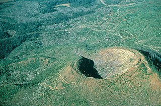
White Horse Bluff is a subaqueous volcano in Wells Gray Provincial Park, east-central British Columbia, Canada.

Clearwater Wilderness is a 14,647-acre (5,927 ha) wilderness area in the North Cascades mountain range, in northern Washington state, of the Northwestern United States. It is located in the Mount Baker-Snoqualmie National Forest, southeast of Tacoma in northeastern Pierce County.

Buck Hill is a hill in east-central British Columbia, Canada, located 17 km (10.6 mi) north of Clearwater. It rises from the west slope of Trophy Mountain. Buck Hill is just outside the boundary of Wells Gray Provincial Park.

<span class="mw-page-title-main">Flourmill Volcanoes</span>

The Flourmill Volcanoes, also known as The Flourmills, are a small volcano range near the west boundary of Wells Gray Provincial Park in east-central British Columbia, Canada. Located north of Mahood Lake and west of the Clearwater River, they form part of the Wells Gray-Clearwater volcanic field.

<span class="mw-page-title-main">Clearwater Lake (British Columbia)</span>

Clearwater Lake is one of six large lakes in Wells Gray Provincial Park in east-central British Columbia, Canada,. The Clearwater River enters the lake at its north end, flowing from Hobson Lake and Azure Lake, and also drains the lake. There are several small streams that flow into Clearwater Lake, but it has no significant tributaries.

<span class="mw-page-title-main">Spahats Creek Falls</span> Waterfall on Spahats Creek in Wells Gray Provincial Park, British Columbia, Canada

Spahats Creek Falls, also called Spahats Falls, is a waterfall on Spahats Creek within Wells Gray Provincial Park of British Columbia, Canada. Common references place the falls at around 60 m (197 ft) tall, but taking into account the second tier, it is closer to 75–80 meters tall. It is a popular stop for tourists and especially motorcoach tours since it is only 10 km (6.2 mi) off the busy Yellowhead Highway.

The Monarch Wilderness is a federally designated wilderness area located 70 miles east of Fresno, California, in the Sierra Nevada mountain range. It encompasses 44,896 acres (181.69 km2) within both the Sequoia National Forest and the Sierra National Forest and is managed by the United States Forest Service. Elevations range from 950 feet (290 m) to 11,081 ft (3,377 m).

<span class="mw-page-title-main">Mahood Lake</span> Lake in British Columbia, Canada

Mahood Lake is a lake in the South Cariboo region of the Interior of British Columbia in Wells Gray Provincial Park. It is drained by the Mahood River, a tributary of the Clearwater River which has cut a deep canyon into Cambrian rocks and Pleistocene glacial moraines. Mahood Lake is fed by the short Canim River, which drains nearby Canim Lake to the west via Canim Falls and Mahood Falls.

<span class="mw-page-title-main">Mahood River</span>

The Mahood River is a river in the northern Shuswap Highland of the Central Interior of British Columbia in Wells Gray Provincial Park. It is 7 kilometres (4.3 mi) long from its source at Mahood Lake to its confluence with the Clearwater River, a tributary of the North Thompson River. The Mahood River has cut a deep canyon into Cambrian rocks and Pleistocene glacial moraines.

McDougall Lake is a lake in Wells Gray Provincial Park in east-central British Columbia, Canada. It drains through File Creek into Murtle Lake.

<span class="mw-page-title-main">Horseshoe Falls (British Columbia)</span>

Horseshoe Falls is one of seven waterfalls on the Murtle River west of Murtle Lake in Wells Gray Provincial Park, east-central British Columbia, Canada. Horseshoe Falls has two steps, 100 m (328 ft) apart; the upper drop is 6 m (20 ft) high and the lower and much wider drop is 10 m (33 ft) high.

<span class="mw-page-title-main">Azure Lake</span> Lake in British Columbia, Canada

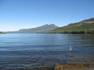
Azure Lake is a fjord-like lake located in east-central British Columbia, Canada. It is an expansion of the Azure River which rises from an unnamed glacier in the Cariboo Mountains. The outflow is also called the Azure River, but it is only 50 m (164 ft) long before it flows into the Clearwater River. Azure Lake is one of the six major lakes in Wells Gray Provincial Park.

<span class="mw-page-title-main">Wells Gray Provincial Park</span> Provincial park in British Columbia, Canada

Wells Gray Provincial Park is a large wilderness park located in east-central British Columbia, Canada. The park protects most of the southern, and highest, regions of the Cariboo Mountains and covers 5,415 square kilometres. It is British Columbia's fifth largest provincial park, after Tweedsmuir, Tatshenshini, Spatsizi and Northern Rocky Mountains.

<span class="mw-page-title-main">Garnet Peak</span>

Garnet Peak is a mountain in east-central British Columbia, Canada, located between Goat Creek and Azure Lake. Situated in the Cariboo Mountains of the Columbia Mountains, it is the third highest mountain in Wells Gray Provincial Park with an elevation of 2,876 m (9,436 ft). Garnet Peak is a prominent mountain as one drives the Clearwater Valley Road into Wells Gray Park and is first visible from 80 km (50 mi) south at the Clearwater Valley Overlook.

<span class="mw-page-title-main">Battle Mountain (British Columbia)</span>

Battle Mountain is a mountain in east-central British Columbia, Canada, located in the south-east region of Wells Gray Provincial Park. The Clearwater River flows to the west, Stevens Lakes are to the east, Philip Creek is to the south and Hemp Creek is to the north. Battle Mountain is part of the Shuswap Highland. There are three summits in the group, ranging from 2,306 m (7,566 ft) to 2,369 m (7,772 ft).

<span class="mw-page-title-main">Moul Falls</span> Waterfall in British Columbia, Canada

Moul Falls is a waterfall on Grouse Creek in Wells Gray Provincial Park, east-central British Columbia, Canada. It is one of the park's most popular short hiking trails. It is the only waterfall in the park that one can stand behind. Moul Falls is the third highest waterfall in the park, measured as a straight, unbroken drop.

<span class="mw-page-title-main">Raft Mountain</span>

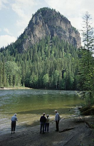
Raft Mountain is a mountain in east-central British Columbia, Canada, located north-east of Clearwater and just outside the south boundary of Wells Gray Provincial Park. The Clearwater River flows to the west, Raft River to the east, Spahats Creek to the north, and North Thompson River to the south. Raft Mountain is part of the Shuswap Highland. There are five summits in the group and the highest is 2,450 m (8,038 ft). Trophy Mountain is the closest summit to the north.

References

  1. 1 2 "Trophy Mountain". Bivouac.com. Retrieved 2021-06-20.
  2. "Trophy Mountain". BC Geographical Names . Retrieved 2021-06-20.
  3. 1 2 3 4 5 6 7 Neave, Roland (2023). Exploring Wells Gray Park (7th ed.). Kamloops, BC.: Wells Gray Tours. ISBN   978-0-9681932-3-5..
  4. Akrigg, G.P.V.; Akrigg, Helen B. (1986), British Columbia Place Names (3rd, 1997 ed.), Vancouver: UBC Press, ISBN   0-7748-0636-2
  5. 1 2 Goward, Trevor and Hickson, Cathie (1995). Nature Wells Gray, 2nd edition. Lone Pine Publishing, Edmonton, AB. ISBN   1-55105-065-X.