
Clearwater is a district municipality in the North Thompson River valley in British Columbia, Canada, where the Clearwater River empties into the North Thompson River. It is located 124 km (77 mi) north of Kamloops. The District of Clearwater was established on December 3, 2007, making it one of the newest municipalities in British Columbia. It is near Wells Gray Provincial Park and is surrounded by the Trophy Mountains, Raft Mountain and Dunn Peak.
Peter Lougheed Provincial Park is in Kananaskis Country about 90 kilometres (56 mi) west of Calgary, along the Kananaskis Trail in Alberta, Canada.

The North Shore Mountains are a mountain range overlooking Vancouver in British Columbia, Canada. Their southernmost peaks are visible from most areas in Vancouver and form a distinctive backdrop for the city.

Caligata Lake Provincial Park is a provincial park in British Columbia, Canada, located northeast of Clearwater. The lake occupies a cirque below the north face of Raft Mountain. The park has no visitor facilities or services.
Monkman Provincial Park is a provincial park in British Columbia, southwest of Tumbler Ridge and northeast of Hansard. Like Monkman Pass, Monkman Lake, Monkman Creek and Monkman Falls, it was named after Alexander Monkman.

The Clearwater River is the largest tributary of the North Thompson River, joining it at the community of Clearwater, British Columbia. The Clearwater rises from glaciers in the Cariboo Mountains and flows in a mostly southerly direction for 201 km (125 mi) to the North Thompson. Its entire course, except the last 5 km (3 mi), is within Wells Gray Provincial Park. Its confluence with the North Thompson is protected by North Thompson River Provincial Park.

Pyramid Mountain is a subglacial mound located on the Murtle Plateau in Wells Gray Provincial Park, east-central British Columbia, Canada.
Buck Hill is a hill in east-central British Columbia, Canada, located 17 km (10.6 mi) north of Clearwater. It rises from the west slope of Trophy Mountain. Buck Hill is just outside the boundary of Wells Gray Provincial Park.

Clearwater Lake is one of six large lakes in Wells Gray Provincial Park in east-central British Columbia, Canada,. The Clearwater River enters the lake at its north end, flowing from Hobson Lake and Azure Lake, and also drains the lake. There are several small streams that flow into Clearwater Lake, but it has no significant tributaries.

Spahats Creek Falls, also called Spahats Falls, is a waterfall on Spahats Creek within Wells Gray Provincial Park of British Columbia, Canada. Common references place the falls at around 60 m (197 ft) tall, but taking into account the second tier, it is closer to 75–80 meters tall. It is a popular stop for tourists and especially motorcoach tours since it is only 10 km (6.2 mi) off the busy Yellowhead Highway.
Misery Mountain, 2,671 feet (814 m), with at least ten well-defined summits, is a prominent 6 mi (9.7 km) long ridgeline in the Taconic Mountains of western Massachusetts and adjacent New York. The west side of the mountain is located in New York; the east side and high point lie within Massachusetts. The summit ridge is part meadow and part wooded with red spruce, balsam fir, and northern hardwood tree species. It is notable for its views of the Hudson River Valley to the west. The 35 mi (56 km) Taconic Crest Trail traverses the crest of the ridgeline, but does not cross the summit.

Horseshoe Falls is one of seven waterfalls on the Murtle River west of Murtle Lake in Wells Gray Provincial Park, east-central British Columbia, Canada. Horseshoe Falls has two steps, 100 m (328 ft) apart; the upper drop is 6 m (20 ft) high and the lower and much wider drop is 10 m (33 ft) high.

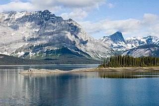
Azure Lake is a fjord-like lake located in east-central British Columbia, Canada. It is an expansion of the Azure River which rises from an unnamed glacier in the Cariboo Mountains. The outflow is also called the Azure River, but it is only 50 m (164 ft) long before it flows into the Clearwater River. Azure Lake is one of the six major lakes in Wells Gray Provincial Park.
Murtle Lake is a lava dammed lake located in Wells Gray Provincial Park, east-central British Columbia, Canada. It is fed primarily by the Murtle River which rises from a large unnamed glacier in the Cariboo Mountains at an elevation of 2,300 m (7,546 ft) and flows southwest for 18 km (11 mi) to the lake. The Murtle River also drains Murtle Lake then flows southwest for 36 km (22 mi) into the Clearwater River.

Wells Gray Provincial Park is a large wilderness park located in east-central British Columbia, Canada. The park protects most of the southern, and highest, regions of the Cariboo Mountains and covers 5,415 square kilometres. It is British Columbia's fifth largest provincial park, after Tweedsmuir, Tatshenshini, Spatsizi and Northern Rocky Mountains.

Garnet Peak is a mountain in east-central British Columbia, Canada, located between Goat Creek and Azure Lake. Situated in the Cariboo Mountains of the Columbia Mountains, it is the third highest mountain in Wells Gray Provincial Park with an elevation of 2,876 m (9,436 ft). Garnet Peak is a prominent mountain as one drives the Clearwater Valley Road into Wells Gray Park and is first visible from 80 km (50 mi) south at the Clearwater Valley Overlook.

Mount Hugh Neave is a mountain in east-central British Columbia, Canada, located between Hobson Lake to the west and Goat Creek to the south. Situated in the Cariboo Mountains of the Columbia Mountains, it is the seventh highest mountain in Wells Gray Provincial Park with an elevation of 2,829 m (9,281 ft).

Trophy Mountain is a mountain in east-central British Columbia, Canada, located in the south-east region of Wells Gray Provincial Park. The Clearwater River flows to the west, Raft River to the east and Spahats Creek to the south. Trophy Mountain is part of the Shuswap Highland. There are nine summits in the group and the highest is 2,577 m (8,455 ft). Battle Mountain and Table Mountain are the closest summits to the north and Raft Mountain is immediately south. Trophy Mountain was given its name by Dan Case, a big-game hunting guide in the area.

Battle Mountain is a mountain in east-central British Columbia, Canada, located in the south-east region of Wells Gray Provincial Park. The Clearwater River flows to the west, Stevens Lakes are to the east, Philip Creek is to the south and Hemp Creek is to the north. Battle Mountain is part of the Shuswap Highland. There are three summits in the group, ranging from 2,306 m (7,566 ft) to 2,369 m (7,772 ft).

Moul Falls is a waterfall on Grouse Creek in Wells Gray Provincial Park, east-central British Columbia, Canada. It is one of the park's most popular short hiking trails. It is the only waterfall in the park that one can stand behind. Moul Falls is the third highest waterfall in the park, measured as a straight, unbroken drop.


