Miao is a sub-division in Changlang district. It is located about 25 km from the Assam border. It is one of the 60 constituencies of Arunachal.
Ganeswarpur is an Indian village. The village falls under the Gop block of Puri District. It was founded before 1500 AD by Puri Gajapati Prataprudra Deva.

Kurnool district is one of the eight districts in the Rayalaseema region of the Indian state of Andhra Pradesh after the districts are reorganised in April 2022. It is located in the north western part of the state and is bounded by Nandyal district in the east, Anantapur district in the south, Raichur district of Karnataka in the northwest, Bellary district of Karnataka in the west, and Jogulamba Gadwal district of Telangana in the north. It has a population of 2,271,686 based on the 2011 census. The city of Kurnool is the headquarters of the district.

Asika or Aska (ଆସିକା)/(ଆସ୍କା) is a town and a Notified Area Council in Ganjam district in the state of Odisha, India. Fondly known as the Sugar city of Odisha.

Bellaguntha is a town and a Notified Area Council (N.A.C.) in Odisha, India which was the main market of South Odisha in the time of British India. Bellaguntha is also known as Brass Fish Town.

Bhanjanagar is a town and an urban region. It is a Notified Area Council in the Ganjam District in the state of Odisha, India. The town, earlier named as Russellkonda after George Russell, President of then board of Revenue, was renamed later after Kavi Samrat Upendra Bhanja. Bhanjanagar is a planned community situated in the confluence of rivers Loharakhandi and Badanadi.
Kotpad is a town and a notified area committee in Koraput district in the Indian state of Odisha. Nearest railway station to Kotpad is Kotpad Road station which is a part of East Coast railway.

Phulbani is a municipality and administrative headquarters of Kandhamal district in the state of Odisha in India.

Chaudhary Muhammad Afzal Sahi is a member of the Sahi Jat family in Faisalabad and is a Pakistani politician.

Jagdishpur is a nagar panchayat town of the district Bhojpur of the state of Bihar in eastern India. It was the capital of the eponymous Jagdishpur estate, ruled by Rajputs of the Ujjainiya clan. One of its rulers, Kunwar Singh, was a major figure in the Indian Rebellion of 1857, considered the leader of the rebellion in Bihar.
Behera(; is a hill town and Gram Panchayat of Dharamgarh Tehsil. It is 20 km from Dharamgarh and 14 km from Athara-Nala forest. Behera Dam is situated nearby which is 18 km from the village. This small hill town is surrounded by forests and is situated nearly to a very well known tourist place Dokrichanchra of Kalahandi. Behera is 65 km distance from its District Main City Bhawanipatna, and 560 km distance from its State Capital Bhubaneswar.
Itamati is a village located in Nayagarh district of Odisha, India. It is 6 km from Nayagarh Town. Itamati is known as the major business centre of Nayagarh, Also known as the second largest village of Odisha.
Chiladangari is a village of Koksara Block in Dharmagarh sub-division in Kalahandi District in Odisha State. This village comes under Phupagaon panchayat of Kokasara Tehsil in Kalahandi District. It also come under kasibahal RI circle. Chiladangari is 7 km distance from Koksara and 60 km distance from its District Main City Bhawanipatna. And 333 km distance from its State Main City Bhubaneswar.

Purrawunda is a rural locality in the Toowoomba Region, Queensland, Australia. In the 2021 census, Purrawunda had a population of 12 people.

Perseverance is a rural locality in the Toowoomba Region, Queensland, Australia. In the 2021 census, Perseverance had a population of 72 people.
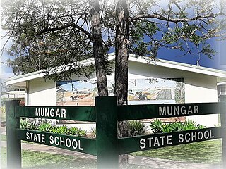
Mungar is a rural locality in the Fraser Coast Region, Queensland, Australia. In the 2021 census, Mungar had a population of 328 people.

Khalana is a village in Kendujhar district in the Indian state of Odisha.
Gladfield is a rural locality in the Southern Downs Region, Queensland, Australia. In the 2016 census Gladfield had a population of 57 people.
Nevilton is a rural locality in the Toowoomba Region, Queensland, Australia. In the 2016 census Nevilton had a population of 33 people.
Blue Mountain is a rural locality in the Isaac Region, Queensland, Australia. In the 2021 census, Blue Mountain had a population of 83 people.
