Beinn Challuim

Last updated

Beinn Challuim
Beinn Challuim 2.jpg
Beinn Challuim seen from the high ground around Crianlarich, 12 km to the south.
Highest point
Elevation 1,025 m (3,363 ft) [1]
Prominence 450 m (1,480 ft)
Listing Munro, Marilyn
Naming
English translationCallum's mountain
Language of name Gaelic
PronunciationScottish Gaelic:  [peɲ ˈxal̪ˠəm]
Geography
Scotland relief location map.jpg
Red triangle with thick white border.svg
Beinn Challuim
Parent range Grampians
OS grid NN386322
Topo map OS Landranger 50, OS Explorer 378
Listed summits of Beinn Challuim
NameGrid refHeightStatus
South Top NN386315 998 m (3274 ft)Munro Top
This view from the west shows both the main summit (left) and the South Top (right) of Beinn Challuim. Beinn Challuim from the west 2.jpg
This view from the west shows both the main summit (left) and the South Top (right) of Beinn Challuim.

Beinn Challuim (English: Ben Challum) is a mountain in the Breadalbane region of the Scottish Highlands. It is east of the village of Tyndrum, in the Forest of Mamlorn, an ancient deer forest at the northern edge of Loch Lomond and the Trossachs National Park. It is a Munro with a height of 1,025 metres (3,363 ft).

Contents

Overview

With a height of 1025 metres (3363 feet) and a prominence of 450 metres (1480 feet) Ben Challuim qualifies as a Munro and a Marilyn. It stands at the head of Glen Lochay and is a prominent peak when seen from the head of that glen, its western slopes dominate the north eastern side of Strath Fillan. When seen from the south the summit of the mountain cannot be seen, being hidden behind the south top. The mountain name was originally written as Beinn Challuim before Ben Challum became the norm. However in recent years the Ordnance Survey have reverted to using the original name on their maps.

The name translates as "Callum's mountain", which could refer to Saint Columba who is known in Scottish Gaelic as "Calum Cille". With St Fillan's priory lying on the south west foothills of the mountain (St Fillan brought Christianity from the monastery of St Columba on Iona into Breadalbane), [2] the Columba connection is feasible. [3]

Geography

Beinn Challuim is often regarded as a smooth grassy hill mainly because these are the characteristics of the southern and western slopes which are seen by many people from the A82 road around Strath Fillan. However from the north it shows a more exciting form with a steep and rocky face overlooking the head of Glen Lochay. Beinn Challuim is made up of three ridges, the broad grassy south west ridge descends to Strath Fillan and is used in ascents from there. The north west ridge is steep and rocky and descends to the Bealach Ghlas-Leathaid (575 metres) and then connects to the Corbett of Cam Chreag. Another ridge goes easterly, descending into Glen Lochay.

The mountain has a subsidiary summit which is listed in the Munro Tables as a “Top”, The South Top reaches a height of 998 metres and lies 600 metres south of the highest point. [4] The two summits are connected by a ridge and this area can be confusing in poor visibility with the logical temptation to go north to the main summit possibly resulting in encountering steep crags. The proper route from the south top is to go initially west for a short distance across a hollow and onto the ridge which leads north to the main summit. [5] The summit ridge has two corries on either side, to the west is the Coire nan Each (Corrie of the Horse) and to the east is Coire Challuim (Callum's Corrie). Drainage from the mountain reaches both coasts of Scotland at the Firth of Tay on the east coast and the Firth of Clyde on the west coast.

Ascents and summit

The most popular route of ascent starts at Kirkton Farm in Strath Fillan (grid reference NN358280 ), this gives the opportunity to visit the ruins of St. Fillans Priory at the beginning or end of the walk. The route continues north east up grassy slopes to reach the summit ridge. [6] A more interesting ascent starts at the road end in Glen Lochay, this gives the chance to view the more noteworthy northern side of the mountain but involves a nine-kilometre walk up the glen to the foot of the eastern ridge. [7] Hamish Brown recommends a northern approach starting at Auch (grid reference NN324355 ) “if you want to be different” but this requires good navigation and some mild scrambling up the north west ridge. [8]

The actual summit of the mountain is named as Stob Glas (greenish-grey peak) on maps and has a large cairn which overlooks the sheer northern face. The view from the top gives fine views of the many peaks around the Tyndrum and Crianlarich area.

Related Research Articles

<span class="mw-page-title-main">Ben Lui</span> 1130m high mountain in Stirling, Scotland, UK

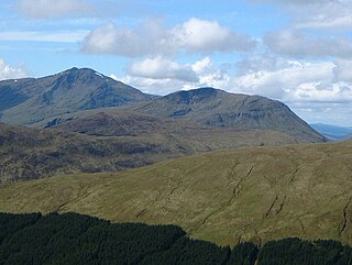
Ben Lui is a mountain in the southern Highlands of Scotland. It is a Munro with a height of 1,130 metres (3,710 ft). Ben Lui is in northeast Argyll and is the highest peak of a mountain chain that includes three other Munros. It has five well-defined ridges radiating out from the summit. Four corries lie between the ridges, including Coire Gaothaich on the northeast side of the mountain.

<span class="mw-page-title-main">Beinn Ghlas</span> Mountain in the Southern Highlands of Scotland

Beinn Ghlas is a mountain in the Breadalbane region of the Scottish Highlands. It lies on the north shore of Loch Tay and is part of the Ben Lawers Range. It is a Munro with a height of 1,103 metres (3,619 ft).

<span class="mw-page-title-main">Mam Sodhail</span>

Mam Sodhail or Màm Sabhail (Gaelic), sometimes anglicised "Mam Soul", is a mountain with a height of 1,181 metres (3,875 ft) in the Northwest Highlands of Scotland. Classed as a Munro, it is beside Carn Eige in the secluded country on the northern side of Glen Affric, some 30 kilometres east of Kyle of Lochalsh.

<span class="mw-page-title-main">Beinn Dubhchraig</span> Mountain in Scotland

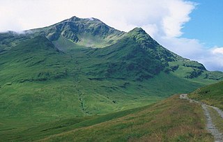
Beinn Dubhchraig is a mountain in the Scottish Highlands, west of Crianlarich in the northern part of Loch Lomond and the Trossachs National Park. It is a Munro with a height of 978 metres (3,209 ft). It is overshadowed by its neighbour Ben Lui, although it is well seen from the main A82 road. Its name means "mountain of the black rock", referromg to the steep and rocky face on the southwest slopes above Loch Oss, which offer scrambling routes to the summit.

<span class="mw-page-title-main">An Caisteal</span>

An Caisteal is a mountain in the Breadalbane region of the Scottish Highlands, south of the village of Crianlarich. It is a Munro with a height of 995 metres (3,264 ft).

<span class="mw-page-title-main">Beinn Achaladair</span>

Beinn Achaladair is a Scottish mountain situated six kilometres north east of the hamlet of Bridge of Orchy. The mountain stands on the border of the Perth and Kinross and Argyll and Bute council areas.

<span class="mw-page-title-main">Sròn a' Choire Ghairbh</span>

Sròn a’ Choire Ghairbh is a Scottish mountain situated on the northern side of Loch Lochy, 13 kilometres north of Spean Bridge in the Highland Council area.

<span class="mw-page-title-main">Beinn a' Chroin</span> Scottish mountain located six kilometres south of Crianlarich in the Stirling Council area

Beinn a' Chroin is a mountain in the Breadalbane region of the Scottish Highlands, six kilometres south of Crianlarich. With a height of 941 metres (3,087 ft) it qualifies as a Munro.

<span class="mw-page-title-main">Cruach Ardrain</span>

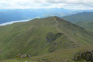
Cruach Ardrain is a Munro mountain in the Breadalbane region of the Scottish Highlands, with a height of 1,046 metres (3,432 feet). It is five kilometres southeast of Crianlarich village and is one of the Crianlarich Hills.

<span class="mw-page-title-main">Beinn Chùirn</span> Scottish hill on the border of Stirlingshire and Perthshire

Beinn Chùirn is a hill five kilometres west-south-west of Tyndrum, Scotland, standing on the border of Stirlingshire and Perthshire at the northern extremity of the Loch Lomond and The Trossachs National Park.

<span class="mw-page-title-main">Ben Oss</span>

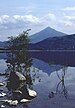
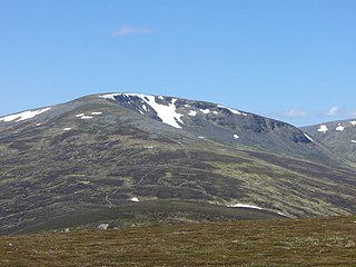
Ben Oss is a mountain in the southern Highlands of Scotland. It is a Munro with a height of 1,029 metres (3,376 ft). Ben Oss is on the border of Argyll and Perthshire, southwest of Tyndrum, within Loch Lomond and the Trossachs National Park. It is part of a mountain chain that includes three other Munros. When viewed from the north or south it is seen as a distinct pointed hill in contrast to its more bulky neighbour Beinn Dubhchraig, with which it is usually climbed. The mountain is quite rocky and craggy being composed of mica schist rock.

<span class="mw-page-title-main">Stob a' Choire Odhair</span>

Stob a' Choire Odhair is a Scottish mountain situated eight kilometres north west of Bridge of Orchy on the border of the Argyll and Bute and Highland council areas.

<span class="mw-page-title-main">Càrn nan Gobhar (Mullardoch)</span>

Càrn nan Gobhar is a mountain rising to 993 metres (3,258 ft) in the Northwest Highlands of Scotland. It stands on the northern side of Loch Mullardoch in the upper part of Glen Cannich, in a remote group of four Munros informally known as "The Mullardochs" which form the high ground between Loch Mullardoch and Loch Monar.

<span class="mw-page-title-main">Creag Mhòr</span>

Creag Mhòr is a mountain in the Breadalbane region of the Scottish Highlands. It is in the Forest of Mamlorn, ten kilometres northeast of Tyndrum, and is one of the remotest of the southern Highlands Creag Mhòr reaches a height of 1047 metres (3435 ft) and qualifies as a Munro and a Marilyn. It is often climbed with the neighbouring Munro of Beinn Heasgarnich; the two mountains form the high ground between Glen Lochay and Loch Lyon.

<span class="mw-page-title-main">Meall Glas</span>

Meall Glas is a mountain situated in the southern highlands of Scotland. It stands on the northern border of the Loch Lomond and the Trossachs National Park, 8.5 kilometres north east of Crianlarich.

<span class="mw-page-title-main">Chno Dearg</span>

Chno Dearg is a mountain in the Lochaber area of the Scottish Highlands. It overlooks Glen Spean to the north and Loch Treig to the west. With a height of 1,046 metres (3,432 ft), it is classed as a Munro.

<span class="mw-page-title-main">Beinn Odhar</span> Mountain in Scotland

Beinn Odhar is a Scottish mountain situated at the northern extremity of the Loch Lomond and the Trossachs National Park. It stands four km (2.5 mi) north of Tyndrum, a location with which it has strong ties, being well seen from the village. The mountain lies on the border between Argyll and Bute and Stirling council areas within the Auch and Invermeran estate.

<span class="mw-page-title-main">Sgairneach Mhòr</span>

Sgairneach Mhòr is a Scottish mountain which lies in a group of seven Munros near the summit of the Pass of Drumochter and are known as the Drumochter mountains or informerly as the “A9 Munros”. The mountain is situated 13 km SSW of Dalwhinnie and four km east of the large Loch Ericht.

<span class="mw-page-title-main">Beinn a' Chaorainn (Glen Spean)</span> Scottish mountain in the Lochaber region of the Highland Council area

Beinn a' Chaorainn is a Scottish mountain situated on the northern side of Glen Spean in the Lochaber region of the Highland Council area. The mountain which is located 30 km east-northeast of Fort William is one of several of the same name in the Scottish Highlands and should not be confused with another well known Beinn a' Chaorainn in the Cairngorms.

<span class="mw-page-title-main">Beinn Bhàn (Arkaig)</span> 796m high mountain in Scotland

Beinn Bhàn is a Scottish mountain situated in the Lochaber region of the Highland Council Area. It stands 6 miles (10 km) north-west of Spean Bridge. The hill is not to be confused with another and better known Beinn Bhàn on the Applecross peninsula.

References

Footnotes

  1. "walkhighlands Ben Challum". walkhighlands.co.uk. 2013. Retrieved 26 October 2013.
  2. A Short History of Breadalbane. Archived July 4, 2007, at the Wayback Machine "St Fillan brought Christianity from the monastery of St Columba on Iona into Breadalbane" .
  3. "The Magic of the Munros" Page 35 (Gives rest of details on name origins and translation).
  4. Database of British and Irish Hills.
  5. www.incallander.co.uk. Archived September 26, 2007, at the Wayback Machine Gives details of dangers of summit ridge.
  6. "The Munros" Page 37 (Gives details of ascent from Strath Fillan).
  7. "The High Mountains of Britain and Ireland" Pages 65 (Details ascent from head of Glen Lochay).
  8. "Hamish's Mountain Walk" Page 73 (Suggests ascent from Auch).

Coordinates: 56°27′14″N4°37′11″W / 56.454°N 4.6198°W / 56.454; -4.6198