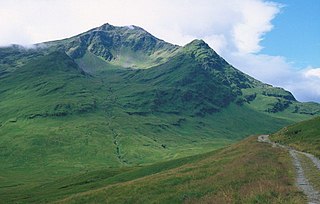
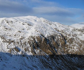
Ben Lui is a mountain in the southern Highlands of Scotland. It is a Munro with a height of 1,130 metres (3,710 ft). Ben Lui is in northeast Argyll and is the highest peak of a mountain chain that includes three other Munros. It has five well-defined ridges radiating out from the summit. Four corries lie between the ridges, including Coire Gaothaich on the northeast side of the mountain.

Beinn a' Bheithir is a mountain south of Ballachulish and Loch Leven in the Scottish Highlands. It has two Munro summits: Sgorr Dhearg at 1,024 m (3,360 ft) and Sgorr Dhonuill at 1,001 m (3,284 ft).

Ben Avon is a mountain in the Cairngorms of Scotland. It is a sprawling mountain with a broad summit plateau dotted with granite tors. One of these marks the summit, called Leabaidh an Daimh Bhuidhe or Stob Easaidh Mòr, which stands at a height of 1,171 metres (3,842 ft). It is classified as both a Munro and a Marilyn.

Sgorr Ruadh is a mountain between Strath Carron and Glen Torridon in Wester Ross in the Northwest Highlands of Scotland. It is located in Coire Lair near Achnashellach along with two other mountains, Beinn Liath Mhòr and Fuar Tholl, and is often climbed together with one or both of these other mountains.
Stùc a' Chroin is a mountain in the Breadalbane region of the southern Scottish Highlands. It is a Munro, with a height of 975 metres (3,199 ft). It lies a short distance south of Ben Vorlich and east of Strathyre. The boundary between the council areas of Perth and Kinross and Stirling passes through the summit of the peak, and the town of Callander lies to the south.

Beinn Fhada or Ben Attow is a mountain in the Scottish Highlands.

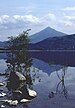
Beinn Dubhchraig is a mountain in the Scottish Highlands, west of Crianlarich in the northern part of Loch Lomond and the Trossachs National Park. It is a Munro with a height of 978 metres (3,209 ft). It is overshadowed by its neighbour Ben Lui, although it is well seen from the main A82 road. Its name means "mountain of the black rock", referromg to the steep and rocky face on the southwest slopes above Loch Oss, which offer scrambling routes to the summit.

An Caisteal is a mountain in the Breadalbane region of the Scottish Highlands, south of the village of Crianlarich. It is a Munro with a height of 995 metres (3,264 ft).

Beinn Achaladair is a Scottish mountain situated six kilometres north east of the hamlet of Bridge of Orchy. The mountain stands on the border of the Perth and Kinross and Argyll and Bute council areas.

Beinn a' Chroin is a mountain in the Breadalbane region of the Scottish Highlands, six kilometres south of Crianlarich. With a height of 941 metres (3,087 ft) it qualifies as a Munro.

Ben Oss is a mountain in the southern Highlands of Scotland. It is a Munro with a height of 1,029 metres (3,376 ft). Ben Oss is on the border of Argyll and Perthshire, southwest of Tyndrum, within Loch Lomond and the Trossachs National Park. It is part of a mountain chain that includes three other Munros. When viewed from the north or south it is seen as a distinct pointed hill in contrast to its more bulky neighbour Beinn Dubhchraig, with which it is usually climbed. The mountain is quite rocky and craggy being composed of mica schist rock.

Beinn Challuim is a mountain in the Breadalbane region of the Scottish Highlands. It is east of the village of Tyndrum, in the Forest of Mamlorn, an ancient deer forest at the northern edge of Loch Lomond and the Trossachs National Park. It is a Munro with a height of 1,025 metres (3,363 ft).

Stob a' Choire Odhair is a Scottish mountain situated eight kilometres north west of Bridge of Orchy on the border of the Argyll and Bute and Highland council areas.
Creag Mhòr is a mountain in the Breadalbane region of the Scottish Highlands. It is in the Forest of Mamlorn, ten kilometres northeast of Tyndrum, and is one of the remotest of the southern Highlands Creag Mhòr reaches a height of 1047 metres (3435 ft) and qualifies as a Munro and a Marilyn. It is often climbed with the neighbouring Munro of Beinn Heasgarnich; the two mountains form the high ground between Glen Lochay and Loch Lyon.

Beinn Sgritheall or Beinn an Sgrithill, also anglicized Ben Sgriol, is the highest mountain on the Glenelg peninsula in the Northwest Highlands of Scotland. It is a Munro with a height of 974 metres (3,196 ft). The main approach is via Arnisdale on the shores of Loch Hourn or via Gleann Beag to the north, with its well-known brochs. The view from the summit was described by Sir Hugh Munro, a founder member of the Scottish Mountaineering Club, as "perhaps the most beautiful I have seen in Scotland".

Càrn Mairg is a mountain in the Breadalbane region of the Scottish Highlands, with a height of 1,042 metres (3,419 ft). It stands in a group of four Munro mountains known as the 'Càrn Mairg group', on the north side of Glen Lyon, Perthshire.

Càrn Gorm is a mountain in the Breadalbane region of the Scottish Highlands, with a height of 1,029 metres (3,376 ft). It stands in a group of four Munro mountains known as the Càrn Mairg group or the Glen Lyon Horseshoe, on the north side of Glen Lyon, Perthshire.

Beinn Odhar is a Scottish mountain situated at the northern extremity of the Loch Lomond and the Trossachs National Park. It stands four km (2.5 mi) north of Tyndrum, a location with which it has strong ties, being well seen from the village. The mountain lies on the border between Argyll and Bute and Stirling council areas within the Auch and Invermeran estate.

Beinn a' Chaisteil is a mountain in the southern Highlands of Scotland, it is located 6.25 km north of Tyndrum on the border of Perth and Kinross and Argyll and Bute council areas. This hill is not to be confused with another Beinn a' Chaisteil, above Loch Vaich in Highland Council area.
Glas Tulaichean is a large, complex mountain in the Mounth, Scotland. It is about 18 kilometres (11 mi) south of Braemar in Perth and Kinross. It is the highest of a group of domed hills which lie in remote land between the head of Glen Tilt and Glen Shee to the east. It is most commonly climbed from the Spittal of Glenshee via Glen Lochsie to the south.