Related Research Articles

The London Borough of Sutton is an Outer London borough in London, England. It covers an area of 43 km2 (17 sq mi) and is the 80th largest local authority in England by population. It borders the London Borough of Croydon to the east, the London Borough of Merton to the north and the Royal Borough of Kingston upon Thames to the north-west; it also borders the Surrey boroughs of Epsom and Ewell to the west and Reigate and Banstead to the south. The local authority is Sutton London Borough Council. Its principal town is Sutton.

Holbeach Air Weapons Range is a United Kingdom Ministry of Defence academic air weapons range (AWR) situated between Boston and King's Lynn in the civil parish of Gedney on The Wash, in Lincolnshire, eastern England.

Sutton is a town in the London Borough of Sutton in South London, England. It is the administrative headquarters of the Outer London borough, on the lower slopes of the North Downs. It is 10 miles (16 km) south-southwest of Charing Cross, one of the fourteen metropolitan centres in the London Plan. The population of the town was counted as 41,483 in the 2011 census, while the borough overall counted 204,525.

Moxley is a village near Darlaston in the Metropolitan Borough of Walsall, West Midlands County, England. It was first developed during the early part of the 19th century when a handful of terraced houses were built to accommodate locals working in factories and mines and the area was created in 1845 out of land from Darlaston, Bilston and Wednesbury.

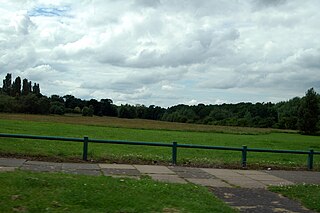
Cheltenham West is an area in the western part of Cheltenham, Gloucestershire, England. It is the generic name for an area which includes the council wards of Hesters Way, Springbank, Arle, Rowanfield, Alstone, Fiddlers Green, St Mark's and some of St Peter's and the Moors.

The Aylesbury Estate is a large housing estate located in Walworth, South East London.

Charterhouse Square is a garden square, a pentagonal space, in Farringdon, in the London Borough of Islington, and close to the former Smithfield Meat Market. The square is the largest courtyard or yard associated with the London Charterhouse, mostly formed of Tudor and Stuart architecture restored after the London Blitz. The square adjoins other buildings including a small school. It lies between Charterhouse Street, Carthusian Street and the main Charterhouse complex of buildings south of Clerkenwell Road. The complex includes a Chapel, Tudor Great Hall, Great Chamber, the Barts and The London School of Medicine and Dentistry and a 40-resident almshouse.

Benhilton is a suburban parish in north Sutton, Greater London. It is dominated by All Saints Church, which is a Grade II* listed building designed by Samuel Sanders Teulon in a Gothic Revival style and opened in 1863. It also contains All Saints Benhilton, C of E Primary and Greenshaw High School.
Pype Hayes is a modern housing estate area and council ward in the east of the Erdington district of Birmingham. It was within the Tyburn ward until 2018. Covering the postcodes of B24 and B76.
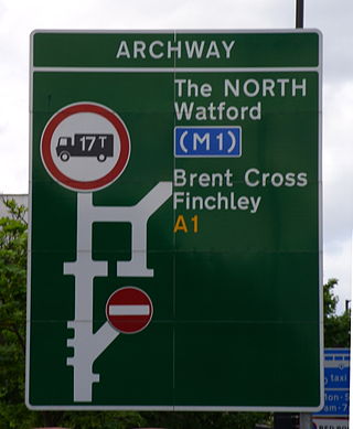
The A1 in London is the southern part of the A1 road. It starts at Aldersgate in the City of London, passing through the capital to Borehamwood on the northern fringe of Greater London, before continuing to Edinburgh. The road travels through the City and three London boroughs: Islington, Haringey and Barnet, which include the districts of Islington, Holloway, Highgate, Hendon and Mill Hill, and travels along Upper Street and Holloway Road, crossing the North Circular Road in Hendon, a district in the London Borough of Barnet.

The Heygate Estate was a large housing estate in Walworth, Southwark, South London, comprising 1,214 homes. The estate was demolished between 2011 and 2014 as part of the urban regeneration of the Elephant & Castle area. Home to more than 3,000 people, it was situated adjacent to Walworth Road and New Kent Road, and immediately east of the Elephant & Castle road intersection. The estate was used extensively as a filming location, due in part to its brutalist architecture.
Sutton-on-Hull is a suburb of the city of Kingston upon Hull, in the ceremonial county of the East Riding of Yorkshire, England. It is located 3 miles (4.8 km) north east of the city centre and has the B1237 road running through it which connects the A165 road with the A1033.

The Empire of Austenasia is a micronation founded in 2008 in the United Kingdom. Operating under the constitutional monarchy of its fourth Emperor, Jonathan I, it consists of dozens of properties that have declared themselves independent under the leadership of a house in the London Borough of Sutton.
Durand Close was a housing estate situated at grid reference TQ 277 661 in Carshalton, Greater London. It held over 300 homes when it was built in the 1960s. In 2009, the estate was demolished to make way for an £83m redevelopment by Rydon Construction Ltd. The River Wandle passes through the estate from Culvers Avenue, with another opening at Buckhurst Avenue and also exits at Buckhurst Avenue.

Kingswood, occasionally referred to as Kingswood Parks, is a modern housing estate on the northern fringe of Kingston upon Hull, England.

Clarion Housing Group is the largest housing association in the United Kingdom with 125,000 properties across more than 170 local authorities. Clarion Provides a home to over 350,000 people.
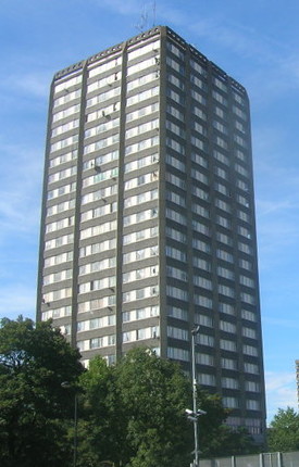
Grenfell Tower is a derelict 24-storey residential tower block in North Kensington in London, England. The tower was completed in 1974 as part of the first phase of the Lancaster West Estate. Most of the tower was destroyed in a severe fire on 14 June 2017.

Phipps Bridge is a housing estate in Mitcham in the London Borough of Merton. It was built following a need created by the end of the Second World War on the site of old slums, and is named after a nearby bridge. Although it opened in the 1960s as a show-piece estate, it took less than ten years for it to become a slum again, and the council continued to redevelop it into the 1990s.

South Kilburn is a large housing estate in Kilburn, in the London Borough of Brent. Typical of brutalist 1960s designs of public housing in the United Kingdom, it is characterised by high-density housing in low-rise flats and 11 concrete tower blocks. It was approved in 1959 and extended in 1963. This scheme was further developed in the late 1960s and early 1970s; redevelopment occurred during the 2010s. The population is predominantly Afro-Caribbean and Pashtun.
References
- ↑ Burgess, Frank. Sutton: A Pictorial History. Phillimore & Co. Ltd. p. 16.
- 1 2 3 4 "Sutton: A brief history". London Borough of Sutton. Archived from the original on 27 September 2013. Retrieved 6 June 2013.
- ↑ Benhill Estate Regeneration - Options Appraisal https://benhill-regen.htadesign.co.uk/storage/app/media/downloads/sut-ben-workshop-1-a1-boards-lo.pdf
- ↑ Benhill Estate Regeneration - Options Appraisal https://benhill-regen.htadesign.co.uk/storage/app/media/downloads/sut-ben-workshop-3-a1-boards-lo.pdf
- ↑ Julia Kennard (18 June 2009). "Indiana Jones' snake man immortalised in national gallery". Suttonguardian.co.uk. Retrieved 3 February 2014.
- ↑ Mike Murphy-Pyle (12 April 2013). "Pensioner dead in flat fire was 'wonderful' snake man Jed Edge". Suttonguardian.co.uk. Retrieved 3 February 2014.
- ↑ Mike Murphy-Pyle (12 April 2013). "Tragedy as neighbours unable to save pensioner in flat fire". Suttonguardian.co.uk. Retrieved 3 February 2014.
| Districts |
|   |
|---|---|---|
| Attractions | ||
| Places of worship | ||
| Parks and open spaces | ||
| Constituencies | ||
| Rail and tram stations | ||
| Other topics | ||