
Oaks Park is a public park in Carshalton in the London Borough of Sutton. It is bounded on the south by Croydon Lane (A2022), and on the east by Woodmansterne Road; smaller roads lie to the west and north.


Oaks Park is a public park in Carshalton in the London Borough of Sutton. It is bounded on the south by Croydon Lane (A2022), and on the east by Woodmansterne Road; smaller roads lie to the west and north.
The park was substantially laid out for the Earl of Derby in the 1770s and changes were made for John Burgoyne in the 1790s for the existing villa (built around 1750 for one Thomas Gosling). The fashionable landscape style was employed with trees forming a perimeter screen and placed in artful clumps to suggest a natural landscape. The house, which was partly rebuilt by Robert Taylor (architect) for John Burgoyne in 1775 and by Robert Adam for the 12th Earl of Derby in 1790, was demolished between 1956 and 1960 [1] but the bakehouse, stable block and some outbuildings remain. Carshalton and District History and Archaeology Society carried out an archaeological investigation in July 2009.
The estate lent its name to the Oaks horserace which was inaugurated by the Earl in 1779 and is run annually during the Derby meeting at Epsom Downs Racecourse, about 4 miles to the west. The original Oaks Race ran from Barrow Hedges, north of The Oaks and through Oaks Park before heading west to approximately the site of the current Epsom Downs Racecourse. Part of the off-road route still exists.

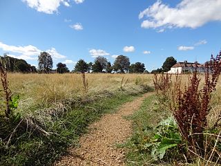
There is a public golf course and sports centre forming part of the open space. The park itself contains a craft centre, a café and a downland countryside walk.
The Oaks Sport Centre has a public golf course and a new indoor climbing and caving centre.
There is a bridle path that goes around the perimeter of the park for riding, cycling, and walking.
The park is on a section of the National Cycle Network (Route 20). [2] A leisure trail along the River Wandle from Wandsworth, starts two miles away from the park at Carshalton and is available from the Sustrans website. [3] The Wandle–Oaks Link joins the park to the Wandle Trail. Section 6 of the London Loop enters the park. [4]
South of the park and close to Croydon Lane is the Mayfield Lavender Field. The field is spectacular during the midsummer months, filling the park with lavender aroma.
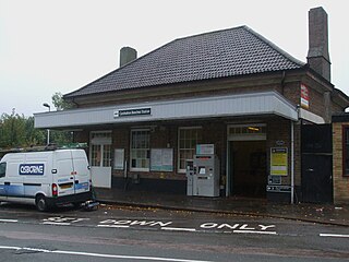
The nearest railway station to the park is at Carshalton Beeches, which is less than a mile walk along Woodmansterne Road. Trains serve various places in South London from here. The 166 bus route serves the park at the Croydon Lane end of the park. The bus route serves Banstead, Purley, and Croydon. [5]

Carshalton is a town, with a historic village centre, in south London, England, within the London Borough of Sutton. It is situated 9.5 miles (15.3 km) south-southwest of Charing Cross, in the valley of the River Wandle, one of the sources of which is Carshalton Ponds in the middle of the village. Prior to the creation of Greater London in 1965, Carshalton was in the administrative county of Surrey.

Waddon is a neighbourhood in the London Borough of Croydon, at the western end of the town of Croydon. The area borders the London Borough of Sutton.

Wallington is a town in the London Borough of Sutton, South London, England, 9.7 miles (15.6 km) south-west of Charing Cross. Before the Municipal Borough of Beddington and Wallington merged into the London Borough of Sutton in Greater London in 1965, it was part of the county of Surrey. Wallington is a post town in the SM postcode area.

The London Borough of Sutton is an Outer London borough in London, England. It covers an area of 43 km2 (17 sq mi) and is the 80th largest local authority in England by population. It borders the London Borough of Croydon to the east, the London Borough of Merton to the north and the Royal Borough of Kingston upon Thames to the north-west; it also borders the Surrey boroughs of Epsom and Ewell to the west and Reigate and Banstead to the south. The local authority is Sutton London Borough Council. Its principal town is Sutton.

Reigate and Banstead is a local government district with borough status in Surrey, England. Its council is based in Reigate and the borough also includes the towns of Banstead, Horley and Redhill. Parts of the borough are within the Surrey Hills, a designated Area of Outstanding Natural Beauty. Northern parts of the borough, including Banstead, lie inside the M25 motorway which encircles London.

Epsom and Ewell is a local government district with borough status in Surrey, England, covering the towns of Epsom and Ewell. The borough lies just outside the administrative boundary of Greater London, but it is entirely within the M25 motorway which encircles London. Many of the borough's urban areas form part of the wider Greater London Built-up Area.

The River Wandle is a right-bank tributary of the River Thames in south London, England. With a total length of about 9 miles (14 km), the river passes through the London boroughs of Croydon, Sutton, Merton and Wandsworth, where it reaches the Thames. A short headwater – the Caterham Bourne – is partially in Surrey, the historic county of the river's catchment. Tributaries of the Wandle include Carshalton Ponds and Norbury Brook.

Tadworth is a large suburban village in Surrey, England in the south-east of the Epsom Downs, part of the North Downs. It forms part of the Borough of Reigate and Banstead. At the 2011 census, Tadworth had a population of 7,123

Sutton railway station (sometimes referred to as Sutton (Surrey) on tickets and timetables) is in the London Borough of Sutton in South London and is the main station serving the town of Sutton. It is served by Southern and Thameslink trains, and lies in Travelcard Zone 5, 14 miles 75 chains (14.94 miles, 24.04 km) down the line from London Bridge, measured via Forest Hill.

Carshalton Beeches railway station is in south Carshalton in the London Borough of Sutton in south London. The station, and all trains serving it, is operated by Southern, and is in Travelcard Zone 5. It is between Wallington and Sutton, 13 miles 72 chains down the line from London Bridge, measured via Forest Hill.

Banstead is a town in the borough of Reigate and Banstead in Surrey, England. It is 3 miles (5 km) south of Sutton, 5 miles (8 km) south-west of Croydon, 8 miles (13 km) south-east of Kingston-upon-Thames, and 13 miles (21 km) south of Central London.

The Epsom Downs Branch is a 3-mile-65-chain (6.1 km) railway line in Greater London and Surrey, England. It runs from Sutton to its southern terminus at Epsom Downs, with intermediate stations at Belmont and Banstead. With the exception of the northernmost 39 ch (780 m), the branch is single track. All stations are managed by Southern, which operates all passenger trains. Most services run between Epsom Downs and London Victoria via Selhurst.

The A217 is a road in London and Surrey in England. It runs north–south. It runs from Kings Road in Fulham, London, crosses the Thames at Wandsworth Bridge, then passes through Wandsworth, Earlsfield, Summerstown, Tooting, Mitcham, Rosehill and Sutton Common in Sutton, then Cheam. Then, widened as a dual carriageway, comes Belmont, a suburban district built on a slope rising southward. On the North Downs in Surrey the road then skirts past Banstead and through its late 19th century offspring villages particularly Burgh Heath and Kingswood, Surrey. It then crosses the M25 motorway at Junction 8, then, returning to single carriageways, passes through the castle town of Reigate. It then cuts through the green buffer farmland of two rural villages and terminates at the road network at Gatwick Airport's northern perimeter.

Nork is a residential area of the borough of Reigate and Banstead in Surrey and borders Greater London, England. Nork is separated from its post town Banstead only by the A217 dual carriageway, and the built-up area is also contiguous with similar parts of Tattenham Corner and Burgh Heath. A thin belt of more open land separates it from the communities to the north: Epsom, Ewell, Cheam and Belmont. There are two parades of shops, one called the Driftbridge and another at the north-eastern end of Nork Way, the street which runs centrally through the residential area. Nork lies on chalk near the top of the gentle north-facing slope of the North Downs, 175 m (575 ft) above sea level at its highest point.

Hackbridge is a suburb in the London Borough of Sutton, south-west London, just over two miles north-east of the town of Sutton itself. It is 8.8 miles (15 km) south-west of Charing Cross.

The A2022 is a non-primary road in England. It runs south-west into the foothills of the North Downs from West Wickham in the London Borough of Bromley through Selsdon, Sanderstead, Addington, Purley, the Woodcote part of that town, Banstead in Surrey and Epsom Downs through which it descends to a similar altitude as at its beginning to end at Epsom.

Woodmansterne is a village in the borough of Reigate and Banstead, Surrey, bordering Greater London, England. It sits on a small plateau of and a southern down slope of the North Downs and its ecclesiastical parish borders continue to span old boundaries and reach into Chipstead, Coulsdon and Wallington.

The Grove Park, or The Grove is a public park in Carshalton in the London Borough of Sutton. It is situated close to Carshalton Village in the area approximately bounded by the High Street, North Street and Mill Lane. The southwest corner of the park abuts one of Carshalton's ponds from where water flows through the park as the river Wandle.
National Cycle Route 22 (NCR22) runs from Banstead to Brockenhurst in the New Forest via Dorking, Guildford, Farnham, Petersfield, Havant, Portsmouth, Ryde, Yarmouth and Lymington. Due to the route going over the Isle of Wight, ferry connections are required from Portsmouth to Ryde, and again from Yarmouth to Lymington.

Sutton Common is the name of former common land and a district and neighbourhood located in Sutton, London. The area is mostly located within the London Borough of Sutton, with some of the streets to the north and west of Sutton Common Park adjoining Lower Morden and Morden within the London Borough of Merton. Much of the area is taken up by the large Kimpton Park commercial and industrial estate, adjoining the A217. It is served by Sutton Common railway station. The area to the south and east of Oldfields Road uses an SM1 postcode and the area to the north and west uses SM3.