
Auras is a town and nagar panchayat in Hasanganj tehsil of Unnao district, Uttar Pradesh, India. First officially classified as a town for the 1981 census, Auras is located just north of the Sai River, on the road from Unnao to Sandila. Other roads branch off to Mohan, Newalganj, and Malihabad.
Hardoi district is a district situated in the center of Uttar Pradesh, India. The district headquarters is in the city of Hardoi. Hardoi is the third largest district of Uttar Pradesh. It falls under Lucknow division in the historical region of Awadh State.

Bighapur is a town and nagar panchayat in Unnao district of Uttar Pradesh, India. First officially classified as a town for the 1981 census, it now serves as a tehsil headquarters(established in Patan). Important items manufactured here include clay pots, leather products, and wooden furniture. As of 2011, the population of Bighapur is 6,501, in 1,201 households.

Fatehpur Chaurasi is a town and a nagar panchayat in Unnao district in the state of Uttar Pradesh, India. First officially classified as a town for the 1981 census, Fatehpur Chaurasi is located on the north bank of the Kalyani river, a bit to the south of the main road from Unnao to Bangarmau. Local industries include the production of furniture, boxes, almirahs, shoes, and slippers. As of 2011, the town's population is 6,715, in 1,158 households.

Ganj Muradabad is a town and nagar panchayat in Bangarmau tehsil of Unnao district, Uttar Pradesh, India. It also serves as the headquarters of a community development block containing 86 rural villages. Handicrafts are a major industry here. As of 2011, Ganj Moradabad has a population of 10,957, in 1,723 households.
Gopamau is a town and nagar panchayat in Hardoi district, Uttar Pradesh, India. Located just west of the Gomti river, Gopamau is a historic town that once served as a pargana headquarters. Important industries include cap making, tobacco, and agricultural products. As of 2011, the population of Gopamau is 15,526, in 2,346 households. The town has several slum areas, which are home to 36.07% of town residents.

Kachhauna Patseni is a town and a nagar panchayat in Sandila tehsil of Hardoi district, Uttar Pradesh, India. It was first upgraded to urban status for the 1981 census. As of 2011, its population is 15,647, in 2,772 households. The Kachhauna community development block encompasses the rural areas surrounding the town.
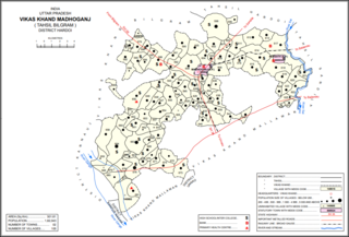
Madhoganj is a town and Nagar Panchayat in Bilgram tehsil of Hardoi district, Uttar Pradesh, India. It is located on the north side of the main road from Sitapur to Kanpur, with other roads leading to Bilgram to the northwest, Mallawan to the south, and Beniganj and Balamau to the east. As of 2011, the population of Madhoganj is 11,523, in 2,180 households. It is also the seat of a community development block.

Maharajganj is a town and nagar panchayat in Rae Bareli district, Uttar Pradesh, India. It serves as the headquarters of a tehsil. As of 2011, its population is 6,673, in 1,037 households.
Maurawan, also spelled Mauranwan, is a town and nagar panchayat in Purwa tehsil of Unnao district, Uttar Pradesh, India. It is located 12 km from Purwa on the road to Raebareli, and 3 km to the southwest of the town is the large Basaha lake. As of 2011, its population is 15,484, in 2,399 households.
Nyotini is a town and nagar panchayat in Hasanganj tehsil of Unnao district, Uttar Pradesh, India. Located 3 km southeast of Hasanganj on the right bank of the Sai river, Nyotini was historically one of the main centres of Muslim settlement in the district and it has several mosques and shrines. As of 2011, its population is 7,577, in 1,212 households.
Parsadepur, also spelled Parshadepur, is a town and a nagar panchayat in Rae Bareli district in the Indian state of Uttar Pradesh. It is located on the north bank of the Sai river, at the crossroads between the road from Salon to Jais and the smaller road from Raebareli to Ateha. Historically noted for its large weaving industry, Parsadepur served as the headquarters of a pargana since the late 18th century. As of 2011, its population is 11,853 people, in 1,738 households.

Safipur is a town and nagar panchayat in Unnao district in the Indian state of Uttar Pradesh. Located 27 km northwest of the city of Unnao, Safipur serves as a tehsil headquarters and is well-connected by roads to nearby towns. Founded in the 1300s and originally called Saipur, the town's present name of Safipur is in honour of the 16th-century Muslim saint Makhdum Shah Safi, whose dargah is located here. Important commodities manufactured in Safipur today include steel boxes and almirahs, furniture, and incense sticks. As of 2011, Safipur's population is 25,688, in 4,288 households.
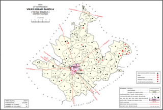
Sandila is a town and nagar palika parishad in Hardoi district in the Indian state of Uttar Pradesh. It serves as a tehsil headquarters within the district. Located midway between Hardoi and Lucknow, Sandila is a well-connected town with roads leading in all directions and a major broad gauge rail line passing through the south side of town. Important industries include sweets — its laddus are especially well-known — as well as beedi production and zardozi work.
Ugu is a town and a nagar panchayat in Unnao district in the Indian state of Uttar Pradesh. First officially classified as a town for the 1981 census, Ugu is an old town with medieval ruins that hosts a biweekly market and an annual mela. It is located on the main Unnao-Hardoi road, a bit northwest of Safipur. Some of the main items manufactured here are shoes, slippers, furniture, and lipstick cover. As of 2011, the population is 6,318, in 1,044 households.
Hyderabad is a town and nagar panchayat in Hasanganj tehsil of Unnao District, Uttar Pradesh, India. It is located on the main Unnao-Sandila road, near its intersection with the road connecting Lucknow and Bangarmau. Major commodities produced in Hyderabad include roasted rice, food products, and earthenware pottery. As of 2011, its population is 7,697 people, in 1,328 households.

Akhand Nagar is a community development block in Kadipur tehsil of Sultanpur district, Uttar Pradesh, India. It consists of 106 inhabited villages with a total population of 168,686 people in 25,112 households.
Gaju is a village in Kachhauna block of Hardoi district, Uttar Pradesh, India. Located on the road from Balamau station to Beniganj and Sitapur, Gaju has a railway station on the Sitapur-Balamau branch line and hosts a market on Mondays and Thursdays. As of 2011, its population is 8,912, in 1,592 households.

Sikandarpur Sarausi is a community development block in Unnao tehsil of Unnao district, Uttar Pradesh, India. It consists of 96 rural villages, with a total population of 185,779 people.

Deenshah Gaura is a community development block in Dalmau tehsil of Raebareli district, Uttar Pradesh, India. It consists of 71 rural villages, with a total population of 104,149 people. The headquarters are located in the village of Gaura Hardo.

