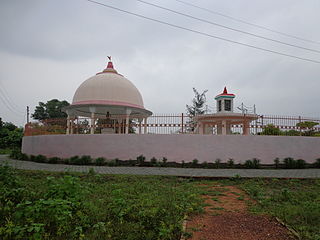
Hardoi is a city and municipal board in Hardoi district in the Indian state of Uttar Pradesh. It is the administrative headquarters of Hardoi district. It is also known as Prahalad Nagari. Hardoi is about 110 km from the state capital Lucknow and about 385 km from New Delhi. Hardoi is a temple town.
Hardoi district is a district situated in the center of Uttar Pradesh, India. The district headquarters is in the city of Hardoi. Hardoi is the third largest district of Uttar Pradesh. It falls under Lucknow division in the historical region of Awadh State.
Beniganj is a town and nagar panchayat in Sandila tehsil of Hardoi district, Uttar Pradesh, India. It is located 21 miles southeast of Hardoi and 16 miles north of Sandila, on the road to Nimkhar and Sitapur.
Gausganj is a census village in the southeast of the Hardoi district in the state of Uttar Pradesh, India. Situated south of Kachhauna, it is located midway between Mallawan and Sandila on the state highway that links them.

Kachhauna Patseni is a town and a nagar panchayat in Sandila tehsil of Hardoi district, Uttar Pradesh, India. It was first upgraded to urban status for the 1981 census. As of 2011, its population is 15,647, in 2,772 households. The Kachhauna community development block encompasses the rural areas surrounding the town.
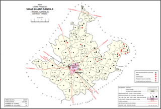
Sandila is a town and nagar palika parishad in Hardoi district in the Indian state of Uttar Pradesh. It serves as a tehsil headquarters within the district. Located midway between Hardoi and Lucknow, Sandila is a well-connected town with roads leading in all directions and a major broad gauge rail line passing through the south side of town. Important industries include sweets — its laddus are especially well-known — as well as beedi production and zardozi work.
Som is a village in Sandila block of Hardoi district, Uttar Pradesh, India. It was previously counted as a census town, but the 2011 census reclassified it as a village. It is connected to state highways and has 3 primary schools and 0 healthcare facilities. As of 2011, its population is 5,040, in 1,135 households.
Balamau is a village in Kachhauna block of Hardoi district, Uttar Pradesh, India. It is located about a mile from the left bank of the Sai river, 25 miles from Hardoi and 4 miles southwest of the namesake Balamau station, which is actually in Kachhauna. Balamau was historically the largest settlement in the area, serving as the seat of a pargana since the reign of Akbar. As of 2011, its population is 4,749, in 1,022 households.

Sandila is an assembly constituency of the Uttar Pradesh Legislative Assembly covering the area of Sandila in Hardoi district of Uttar Pradesh, India. Sandila is one of five assembly constituencies in the Misrikh Lok Sabha constituency. Since 2008, this assembly constituency is numbered 161 amongst 403 constituencies. Currently this constituency is represented by Alka Singh Arkvanshi, who won in 2022 Uttar Pradesh Legislative Assembly election.

Mohan Lal Verma was a leader of Indian independence movement and a lifelong follower of Mahatma Gandhi. After independence he was appointed as MLC - Member of the State Legislative Council from Hardoi constituency from 1948 to 1952. After this tenure he also served the district of Hardoi for a decade as MLA- Member of the Legislative Assembly for two consecutive terms from 1957 to 1967. He won his first MLA election from Sandila constituency in 1957 and again in 1962 from erstwhile Gondwa constituency. Even after his political career he continued to serve the people of Hardoi and bring development to the district until his death.

Pura Bahadur is a village in Tadiyawan block of Hardoi district, Uttar Pradesh, India. Located a few kilometres from the city of Hardoi, the village is connected to state highways and hosts a market on Wednesdays and Sundays. Pura Bahadur has two primary schools and a sub post office. There are no hospitals for humans, although there is a veterinary facility. The main staple foods are wheat and rice. As of 2011, the population of Pura Bahadur is 5,594, in 964 households.
Japra is a village in Tadiyawan block of Hardoi district, Uttar Pradesh, India. Located 16 km from the city of Hardoi, the village is not on any major roads and it has 3 primary schools but no healthcare facilities. The main staple foods are wheat and rice. As of 2011, the population of Japra is 3,633, in 555 households.
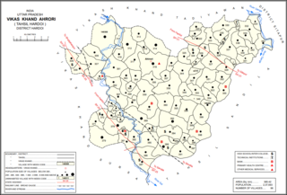
Ahrori, also spelled Ahirori, is a village and corresponding community development block in Hardoi district of Uttar Pradesh, India. Located 24 km from the city of Hardoi, it hosts a regular market and hosts a Babaji festival on Asadha Sudi 15 dedicated to worship of the goddess Devi. The village has two primary schools and one clinic, as well as a public library and a sub post office. As of 2011, the population of Ahrori is 8,382, in 1,329 households.
Kalyanmal is a village in Kothwan block of Hardoi district, Uttar Pradesh, India. Historically, the seat of a pargana, Kalyanmal is located 11 km from the city of Beniganj, on the north side of the road leading to Atrauli and Bhatpurwaghat. Also close by is the road running from Sandila to Gundlamau in Sitapur district. Every Sunday during the month of Bhadon, a fair is held at Hattia Haran, a tank south of Kalyanmal where the god Rama is said to have bathed. Kalyanmal also hosts a small fair to Panchabgir Mahadeo during the month of Aghan. As of 2011, the population of Kalyanmal is 8,295, in 1,532 households.
Gaju is a village in Kachhauna block of Hardoi district, Uttar Pradesh, India. Located on the road from Balamau station to Beniganj and Sitapur, Gaju has a railway station on the Sitapur-Balamau branch line and hosts a market on Mondays and Thursdays. As of 2011, its population is 8,912, in 1,592 households.

Behadar, also Behadar Kala, is a village and corresponding community development block in Hardoi district of Uttar Pradesh, India. There is a market at Behadar Kalan Hashimpore on Wednesdays and Sundays, with no particular specialisation. The village has 3 primary schools and 0 healthcare facilities. As of 2011, the population of Behadar is 4,458, in 1,194 households.

Bharawan is a village and corresponding community development block in Sandila tehsil of Hardoi district, Uttar Pradesh, India. Located 23 km from Sandila, it hosts a market on Mondays and Thursdays and has four primary schools and one healthcare facility. The main staple foods are wheat and juwar. As of 2011, the population of Bharawan is 10,443, in 1,649 households.

Hardoi is a village in Maharajganj block of Rae Bareli district, Uttar Pradesh, India. Located on the road from Maharajganj to Bachhrawan, Hardoi historically served as the seat of a pargana and has a now-ruined fort built in the early 1400s under the Jaunpur Sultanate. As of 2011, its population is 2,308, in 415 households.
Mahgawan is a large village in Sandila block of Hardoi district, Uttar Pradesh, India. It is located to the north of Sandila.
Alka Singh Arkvanshi is an Indian politician from Uttar Pradesh. She is an MLA from Sandila Assembly constituency in Hardoi district. She represents of Bharatiya Janata party. She won the 2022 Uttar Pradesh Legislative Assembly election.

