
Unnao is an important city of Kanpur Metropolis in the Indian state of Uttar Pradesh. Unnao is located on the eastern bank of the Ganges River. Unnao is a satellite city of Kanpur. Administratively Unnao city lies within Unnao district and is the headquarters of the Unnao Sadar subdivision. Unnao city also falls under Kanpur Metropolitan Development Authority.

Roorkee is a city and a municipal corporation in the Haridwar district of the state of Uttarakhand, India. It is 31 km (19 mi) from Haridwar city, the district headquarter. It is spread over a flat terrain under Sivalik Hills of Himalayas. The city is developed on the banks of Ganges Canal, its dominant feature, which flows from north–south through middle of the city. Roorkee is home to Asia's first engineering college Indian Institute of Technology Roorkee, formerly known as Thomson College of Civil Engineering. Roorkee is also known for the Roorkee Cantonment, one of the country's oldest military establishments and the headquarters of Bengal Engineer Group since 1853. A freight train ran in between Roorkee and Piran Kaliyar on 22 December 1851, this was two years before first passenger trains were started between Bombay and Thana in 1853 and 14 years after first freight trains ran in Chennai in 1837.
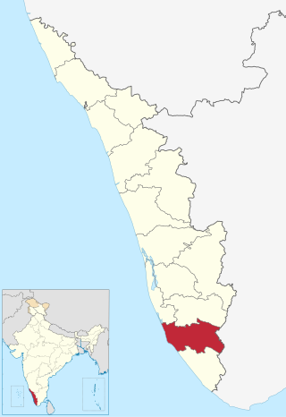
Kollam district, is one of 14 districts of the state of Kerala, India. The district has a cross-section of Kerala's natural attributes; it is endowed with a long coastline, a major Laccadive Sea seaport and an inland lake. The district has many water bodies. Kallada River is one among them, and land on the east bank of the river is East Kallada and that on the west bank is West Kallada.

Begusarai District is one of the thirty-eight districts of the Indian state of Bihar. The city of Begusarai is its administrative headquarters and is part of the Munger division.
Pratapgarh, also called Belha or Bela Pratapgarh, is a town and municipality in the state of Uttar Pradesh in India. It is the administrative headquarters of Pratapgarh district, part of the Prayagraj division.

Washim district is a district in Maharashtra, India. The headquarters is at Washim. The area of the district is 5,150 km2 (1,990 sq mi).

Bhind district is a district in the Chambal division of the Indian state of Madhya Pradesh.

Dewas District is a district in the Indian state of Madhya Pradesh. The town of Dewas is the district headquarters. It belongs to Ujjain Division.

Ratlam District is a district of Madhya Pradesh state in central India. The town of Ratlam is administrative headquarters of the district.
Hardoi district is a district situated in the center of Uttar Pradesh, India. The district headquarters is in the city of Hardoi. Hardoi is the third largest district of Uttar Pradesh. It falls under Lucknow division in the historical region of Awadh State.

Raebareli district is a district of Uttar Pradesh state in northern India. The city of Raebareli is the district headquarters. This district is a part of Lucknow Division in Uttar Pradesh state. The total area of Raebareli district is 3,371 Sq. km.
Bandipore or Bandipora is the headquarters of district of Bandipore in the union territory of Jammu and Kashmir, India. It is located on the northern banks of Wullar Lake—the second-largest freshwater lake in Asia. Also highest Mountain peak of Kashmir Valley Mt Harmukh is in Bandipora.Bandipora has a terraced garden similar to that of Nishat Bagh in Srinagar. Bandipora is bound by mountains on three sides and by Wular Lake on the fourth. As per folklore, the name of Bandipora originated either from Bund of Wular as Bund e pur, from the local folk-singing bands (bāṇd) as Baand e pur or from the enclosed (band) geographical location as Bandh e pur.
Dighwara is a town and a Nagar Panchayat in the Saran district, state of Bihar, India. The name probably derives from 'Dirgh-dwar', literally "large gate", as Dighwara is claimed to be the entrance to the mythological city of king Daksha. During British Rule it was a Feudal Estate ruled by the Raghuvanshis.The town lies on the banks of Ganges River. A road bridge has been planned to be constructed over Ganges, between Dighwara and Danapur.

Salon is a town and nagar panchayat in Raebareli district in the Indian state of Uttar Pradesh. It serves as the headquarters of a tehsil as well as a community development block. Originally it was also the headquarters of the entire district, but they were moved after the Indian Rebellion of 1857. It is located a bit to the south of the Sai river, at the junction of the Raebareli-Pratapgarh and Jais-Khaga roads. Other roads lead to Dalmau, Manikpur, and Kunda. To the east is a large jhil.

Kunda is a town and a Tehsil in Pratapgarh district in the Indian state of Uttar Pradesh.

Pratapgarh district is the 33rd district of Rajasthan, created on 26 January 2008. It is a part of Udaipur Division and has been carved out from the erstwhile tehsils of Chittorgarh, Udaipur and Banswara districts. Pratapgarh town is the administrative headquarters of the district.
Peepal Khoont mainly known as Pipalkhunt is a village, Tehsil headquarter and Panchayat Samiti of the Pratapgarh district of Rajasthan state. It is a sub-division among the 5 sub-divisions of the Pratapgarh district. The main market is called Sadar Bajar. It is situated on National Highway 113. Pipalkhunt is a town located on the Banswara - Jaipur Expressway surrounded by the hills, plants and trees. The town is situated on the bank of the Mahi River.
Heeraganj is a village in Kunda tehsil, Babaganj block basically famous by her attitude Posted by gaurav pandit Pratapgarh district of Indian state Uttar Pradesh.
Rongli is a town, in the Pakyong district of the Indian state of Sikkim. It lies on the banks of Rangpo River around 22 kilometres (14 mi) from Pakyong city, the district headquarters, and around 69 kilometres (43 mi) by road south of the state capital Gangtok. Rongli is also the headquarter of Rongli Subdivision of Pakyong district. Rongli is one of the oldest market of Sikkim that lies on the trade route between Kalimpong and Tibet.
Bahupur is a village of Patti tehsil. Pratapgarh is a district of Bahupur. Pratapgarh district, Uttar Pradesh is in India. Bahupur belongs to Allahabad Division. It is located 27 km towards East from District headquarters Pratapgarh, 9 km from Mangraura and 180 km from State capital Lucknow. Nearest airport to the village is Allahabad Airport, 59.77 km and nearest Railway Station is Khundaur railway station which is about 11.78 km away. The Bahupur village has population of 1233 of which 564 are males while 669 are females as per Population Census 2011.

