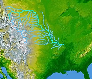
The Missouri River is the longest river in the United States. Rising in the eastern Centennial Mountains of the Bitterroot Range of the Rocky Mountains of southwestern Montana, the Missouri flows east and south for 2,341 miles (3,767 km) before entering the Mississippi River north of St. Louis, Missouri. The river drains semi-arid watershed of more than 500,000 square miles (1,300,000 km2), which includes parts of ten U.S. states and two Canadian provinces. Although a tributary of the Mississippi, the Missouri River is slightly longer and carries a comparable volume of water. When combined with the lower Mississippi River, it forms the world's fourth-longest river system.

Fort Benton is a city in and the county seat of Chouteau County, Montana, United States. Established in 1846, Fort Benton is the oldest continuously occupied settlement in Montana. Fort Benton was the most upstream navigable port on the Mississippi River System, and is considered "the world’s innermost port".

The territory of the United States and its overseas possessions has evolved over time, from the colonial era to the present day. It includes formally organized territories, proposed and failed states, unrecognized breakaway states, international and interstate purchases, cessions, and land grants, and historical military departments and administrative districts. The last section lists informal regions from American vernacular geography known by popular nicknames and linked by geographical, cultural, or economic similarities, some of which are still in use today.

The Battle of Killdeer Mountain took place during Brig. Gen. Alfred Sully's expedition against the Sioux in Dakota Territory July 28–29, 1864. The location of the battleground is in modern Dunn County, North Dakota. With a total of more than 4,000 soldiers involved in the total operation, and more than 2,000 in the battle, Sully's expedition was the largest ever carried out by the U.S. army against Native Americans.

The American Fur Company (AFC) was founded in 1808, by John Jacob Astor, a German immigrant to the United States. During the 18th century, furs had become a major commodity in Europe, and North America became a major supplier. Several British companies, most notably the North West Company and the Hudson's Bay Company, were eventual competitors against Astor and capitalized on the lucrative trade in furs. Astor capitalized on anti-British sentiments and his commercial strategies to become one of the first trusts in American business and a major competitor to the British commercial dominance in North American fur trade. Expanding into many former British fur-trapping regions and trade routes, the company grew to monopolize the fur trade in the United States by 1830, and became one of the largest and wealthiest businesses in the country.

Fort Union Trading Post National Historic Site is a partial reconstruction of the most important fur trading post on the upper Missouri River from 1829 to 1867. The fort site is about two miles from the confluence of the Missouri River and its tributary, the Yellowstone River, on the Dakota side of the North Dakota/Montana border, 25 miles from Williston, North Dakota.

The Great Falls of the Missouri River are a series of waterfalls on the upper Missouri River in north-central Montana in the United States. From upstream to downstream, the five falls along a 10-mile (16 km) segment of the river are:

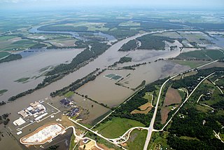
DeSoto National Wildlife Refuge, created in 1958, is located along the banks of the Missouri River in the U.S. states of Iowa and Nebraska. The 8,362-acre (3,384 ha) refuge preserves an area that would have been otherwise lost to cultivation. In 1960, an Army Corps of Engineers channelization project on the Missouri River moved the main river channel in the area to the west. The former river channel became DeSoto Lake, a seven-mile long oxbow lake. As a result, part of the Nebraska portion of the refuge lies on the east side of the Missouri River.
Fort Lisa (1812–1823) was established in 1812 in what is now North Omaha in Omaha, Nebraska by famed fur trader Manuel Lisa and the Missouri Fur Company, which was based in Saint Louis. The fort was associated with several firsts in Nebraska history: Lisa was the first European farmer in Nebraska; it was the first settlement by American citizens set up in the then-recent Louisiana Purchase; Lisa's wife was the first woman resident of European descent in Nebraska; and the first steamboat to navigate Nebraska waters, the Western Engineer, arrived at Fort Lisa in September 1819.
Galvanized Yankees was a term from the American Civil War denoting former Confederate prisoners of war who swore allegiance to the United States and joined the Union Army. Approximately 5,600 former Confederate soldiers enlisted in the United States Volunteers, organized into six regiments of infantry between January 1864 and November 1866. Of those, more than 250 had begun their service as Union soldiers, were captured in battle, then enlisted in prison to join a regiment of the Confederate States Army. They surrendered to Union forces in December 1864 and were held by the United States as deserters, but were saved from prosecution by being enlisted in the 5th and 6th U.S. Volunteers. An additional 800 former Confederates served in volunteer regiments raised by the states, forming ten companies. Four of those companies saw combat in the Western Theater against the Confederate Army, two served on the western frontier, and one became an independent company of U.S. Volunteers, serving in Minnesota.

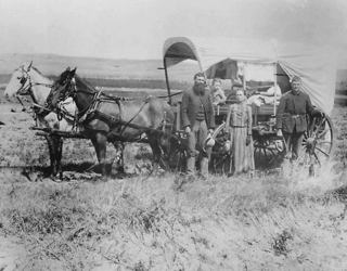
The history of the U.S. state of Nebraska dates back to its formation as a territory by the Kansas–Nebraska Act, passed by the United States Congress on May 30, 1854. The Nebraska Territory was settled extensively under the Homestead Act of 1862 during the 1860s, and in 1867 was admitted to the Union as the 37th U.S. state. The Plains Indians are the descendants of a long line of succeeding cultures of indigenous peoples in Nebraska who occupied the area for thousands of years before European arrival and continue to do so today.

The Missouri River Valley outlines the journey of the Missouri River from its headwaters where the Madison, Jefferson and Gallatin Rivers flow together in Montana to its confluence with the Mississippi River in the State of Missouri. At 2,300 miles (3,700 km) long the valley drains one-sixth of the United States, and is the longest river valley on the North American continent. The valley in the Missouri River basin includes river bottoms and floodplains.

The area that eventually became the U.S. state of Montana played little direct role in the American Civil War. The closest the Confederate States Army ever came to the area was New Mexico and eastern Kansas, each over a thousand miles away. There was not even an organized territory using "Montana" until the Montana Territory was created on May 26, 1864, three years after the Battle of Fort Sumter. In 1861, the area was divided between the Dakota Territory and the Washington Territory, and in 1863, it was part of the Idaho Territory.

Peter Abadie Sarpy (1805–1865) was the French-American owner and operator of several fur trading posts, essential to the development of the Nebraska Territory, and a thriving ferry business. A prominent businessman, he helped lay out the towns of Bellevue and Decatur, Nebraska. Nebraska's legislature named Sarpy County after him in honor of his service to the state.
Camp Cooke also known as Fort Claggett was a U.S. Army military post on the Missouri River in Montana Territory. The camp was established on July 10, 1866, just upstream from the mouth of the Judith River by the 13th Infantry Regiment. By 1867 Camp Cooke had a strength of approximately 400 men. The army established the post to protect steamboat traffic en route to Fort Benton. The boats carried passengers and freight to supply swiftly growing boom towns at the site of rich gold strikes in the western mountains of the Montana Territory.

The fur trade in Montana was a major period in the area's economic history from about 1800 to the 1850s. It also represents the initial meeting of cultures between indigenous peoples and those of European ancestry. British and Canadian traders approached the area from the north and northeast focusing on trading with the indigenous people, who often did the trapping of beavers and other animals themselves. American traders moved gradually up the Missouri River seeking to beat British and Canadian traders to the profitable Upper Missouri River region.
The 12th Missouri Cavalry Regiment was a cavalry regiment that served in the Union Army during the American Civil War and American Indian Wars.
Horace Ezra Bixby was a steamboat pilot on the Mississippi-Missouri-Ohio river system from the late 1840s until his death in 1912. Bixby is notable in his own right for his high standing in his profession, for his technical contributions to it, and for his service in the American Civil War. However, he is best known for having had as his "cub pilot" the young man known to him as Sam Clemens, later to become famous under his pen name as American author Mark Twain. Twain's descriptions of Bixby's character and pedagogic style form a good part of his memoir Life on the Mississippi, and it was through this medium that Bixby—much to his annoyance—became well-known beyond the circles of his family, friends and profession.

Joseph Marie LaBarge was an American steamboat captain, most notably of the steamboats Yellowstone, and Emilie, that saw service on the Mississippi and Missouri rivers, bringing fur traders, miners, goods and supplies up and down these rivers to their destinations. During much of his career LaBarge was in the employ of the American Fur Company, a giant in the fur trading business, before building his own steamboat, the Emilie, to become an independent riverman. During his career he exceeded several existing speed and distance records for steamboats on the Missouri River. Passengers aboard his vessels sometimes included notable people, including Abraham Lincoln. LaBarge routinely offered his steamboat services gratis to Jesuit missionaries throughout his career.

The Spread Eagle was a steam-driven sidewheel riverboat that transported passengers, goods and supplies to the forts and trading posts along the Missouri River between 1857–1864. It was constructed and launched at Brownsville, Pennsylvania. The vessel was a wooden hull packet, 210 feet (64 m) long, with a beam of 36 feet (11 m), a draft of 6 feet (1.8 m), and was rated at 389 tons. It was powered by two steam engines with 3 boilers each, at 40 inches (1,000 mm) in diameter and 24 feet (7.3 m) in length. The Spread Eagle was constructed by Captain Benjamin Johnson who sold the vessel to the American Fur Company upon her arrival at Saint Louis, Missouri. Commanded by captain Bailey, she was once engaged in a race along the Missouri from St. Louis to Fort Benton where she rammed her opponent.


