
The Bóbr is a river which carries water through the north of the Czech Republic and the southwest of Poland. It is a left tributary of the Oder.

Żary County is a unit of territorial administration and local government (powiat) in Lubusz Voivodeship, western Poland, on the German border. It came into being on January 1, 1999, as a result of the Polish local government reforms passed in 1998. Its administrative seat and largest town is Żary, which lies 43 km (27 mi) south-west of Zielona Góra and 123 km (76 mi) south of Gorzów Wielkopolski. The county contains three other towns: Lubsko, lying 21 km (13 mi) north-west of Żary, Jasień, lying 16 km (10 mi) north-west of Żary, and Łęknica, 30 km (19 mi) west of Żary.

Zielona Góra County is a unit of territorial administration and local government (powiat) in Lubusz Voivodeship, western Poland. It came into being on January 1, 1999, as a result of the Polish local government reforms passed in 1998. Its administrative seat is the city of Zielona Góra, although the city is not part of the county. The county contains five towns: Sulechów, which lies 23 km (14 mi) north-east of Zielona Góra, Nowogród Bobrzański, which lies 25 km (16 mi) south-west of Zielona Góra, Babimost, which lies 40 km (25 mi) north-east of Zielona Góra, Czerwieńsk, which lies 11 km (7 mi) north-west of Zielona Góra, and Kargowa, 40 km (25 mi) north-east of Zielona Góra.

Międzyrzecz County is a unit of territorial administration and local government (powiat) in Lubusz Voivodeship, western Poland. It came into being on January 1, 1999, as a result of the Polish local government reforms passed in 1998. Its administrative seat and largest town is Międzyrzecz, which lies 48 km (30 mi) south-east of Gorzów Wielkopolski and 68 km (42 mi) north of Zielona Góra. The county also contains the towns of Skwierzyna, lying 19 km (12 mi) north of Międzyrzecz, and Trzciel, 25 km (16 mi) south-east of Międzyrzecz.

Świebodzin County is a unit of territorial administration and local government (powiat) in Lubusz Voivodeship, western Poland. It came into being on January 1, 1999, as a result of the Polish local government reforms passed in 1998. Its administrative seat and largest town is Świebodzin, which lies 35 km (22 mi) north of Zielona Góra and 57 km (35 mi) south of Gorzów Wielkopolski. The only other town in the county is Zbąszynek, lying 20 km (12 mi) east of Świebodzin.

Krosno County is a unit of territorial administration and local government (powiat) in Lubusz Voivodeship, western Poland, on the German border. It came into being on January 1, 1999, as a result of the Polish local government reforms passed in 1998. Its administrative seat is the town of Krosno Odrzańskie, which lies 30 km (19 mi) west of Zielona Góra and 79 km (49 mi) south of Gorzów Wielkopolski. The only other town is Gubin which is the biggest town in the county. It is situated on the German border 28 km (17 mi) west of Krosno Odrzańskie.

Żagań County is a unit of territorial administration and local government (powiat) in Lubusz Voivodeship, western Poland. It came into being on January 1, 1999, as a result of the Polish local government reforms passed in 1998. Its administrative seat and largest town is Żagań, which lies 39 km (24 mi) south of Zielona Góra and 124 km (77 mi) south of Gorzów Wielkopolski. The county contains four other towns: Szprotawa, lying 14 km (9 mi) south-east of Żagań, Iłowa, lying 15 km (9 mi) south-west of Żagań, Małomice, lying 12 km (7 mi) south-east of Żagań, and Gozdnica, 25 km (16 mi) south-west of Żagań.

Wschowa County is a unit of territorial administration and local government (powiat) in Lubusz Voivodeship, western Poland. It was created in 2002 out of three gminas which previously belonged to Nowa Sól County. Its administrative seat and largest town is Wschowa, which lies 57 km (35 mi) east of Zielona Góra and 126 km (78 mi) south-east of Gorzów Wielkopolski. The county also contains the towns of Sława, lying 18 km (11 mi) north-west of Wschowa, and Szlichtyngowa, 10 km (6 mi) south of Wschowa.
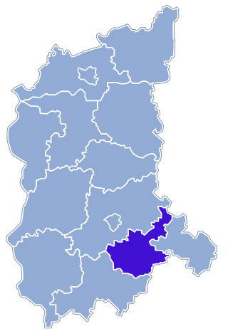
Nowa Sól County is a unit of territorial administration and local government (powiat) in Lubusz Voivodeship, western Poland. It came into being on January 1, 1999, as a result of the Polish local government reforms passed in 1998. Its administrative seat and largest town is Nowa Sól, which lies 22 km (14 mi) south-east of Zielona Góra and 109 km (68 mi) south of Gorzów Wielkopolski. The county contains three other towns: Kożuchów, lying 10 km (6 mi) south-west of Nowa Sól, Bytom Odrzański, lying 11 km (7 mi) south-east of Nowa Sól, and Nowe Miasteczko, 13 km (8 mi) south of Nowa Sól.

Zielona Góra Airport is a regional airport in the Zielona Góra urban area in western Poland. The airport is 10 km (6.2 mi) from Sulechów, 35 km (22 mi) northeast of the Zielona Góra city centre, in the village of Kramsko, near the town of Babimost, 95 km (59 mi) west of Poznań, 90 km (56 mi) east of the German border, and 170 km (110 mi) from Berlin. Its catchment area consists of the three million inhabitants of Lubusz Land and the west of Greater Poland (Wielkopolska).
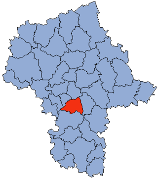
Piaseczno County is a unit of territorial administration and local government (powiat) in Masovian Voivodeship, east-central Poland. It came into being on January 1, 1999, as a result of the Polish local government reforms passed in 1998. Its administrative seat and largest town is Piaseczno, which lies 17 kilometres (11 mi) south of Warsaw. The county contains three other towns: Konstancin-Jeziorna, 8 km (5 mi) east of Piaseczno, Góra Kalwaria, 18 km (11 mi) south-east of Piaseczno, and Tarczyn, 16 km (10 mi) south-west of Piaseczno.

Rawicz County is a unit of territorial administration and local government (powiat) in Greater Poland Voivodeship, west-central Poland. It came into being on January 1, 1999, as a result of the Polish local government reforms passed in 1998. Its administrative seat and largest town is Rawicz, which lies 88 kilometres (55 mi) south of the regional capital Poznań. The county contains three other towns: Miejska Górka, 9 km (6 mi) north-east of Rawicz, Bojanowo, 13 km (8 mi) north-west of Rawicz, and Jutrosin, 22 km (14 mi) east of Rawicz.

Nowy Tomyśl County is a unit of territorial administration and local government (powiat) in Greater Poland Voivodeship, west-central Poland. It came into being on January 1, 1999, as a result of the Polish local government reforms passed in 1998. Its administrative seat and largest town is Nowy Tomyśl, which lies 55 kilometres (34 mi) west of the regional capital Poznań. The county contains three other towns: Opalenica, 20 km (12 mi) east of Nowy Tomyśl, Zbąszyń, 17 km (11 mi) south-west of Nowy Tomyśl, and Lwówek, 16 km (10 mi) north of Nowy Tomyśl.
Borszyn Wielki is a village in the administrative district of Gmina Góra, within Góra County, Lower Silesian Voivodeship, in south-western Poland. Prior to 1945 it was in Germany.
Brzeżany is a village in the administrative district of Gmina Góra, within Góra County, Lower Silesian Voivodeship, in south-western Poland. Prior to 1945 it was part of Germany.
Stara Góra is a village in the administrative district of Gmina Góra, within Góra County, Lower Silesian Voivodeship, in south-western Poland. Prior to 1945 it was in Germany.

Górka Wąsoska is a village in the administrative district of Gmina Wąsosz, within Góra County, Lower Silesian Voivodeship, in south-western Poland.
Kamień Górowski is a village in the administrative district of Gmina Wąsosz, within Góra County, Lower Silesian Voivodeship, in south-western Poland.
Sułów Wielki is a village in the administrative district of Gmina Wąsosz, within Góra County, Lower Silesian Voivodeship, in south-western Poland.

Białogóra is a village in the administrative district of Gmina Krokowa, within Puck County, Pomeranian Voivodeship, in northern Poland. It lies approximately 14 kilometres (9 mi) west of Krokowa, 32 km (20 mi) north-west of Puck, and 67 km (42 mi) north-west of the regional capital Gdańsk. It is located on the Slovincian Coast in the historic region of Pomerania.

