Big Pool, Maryland

Last updated

Big Pool, Maryland
Big Pool on 14 mile Level looking from towpath.jpg
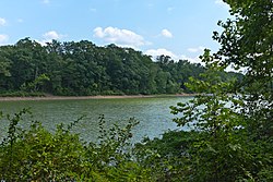
Big Pool, the body of water formed when the Chesapeake and Ohio Canal was made, which gave the name to the area
USA Maryland location map.svg
Red pog.svg
Big Pool, Maryland
Usa edcp location map.svg
Red pog.svg
Big Pool, Maryland
Coordinates: 39°37′26″N78°00′56″W / 39.62389°N 78.01556°W / 39.62389; -78.01556
CountryUnited States
State Maryland
County Washington
Area
[1]
  Total0.11 sq mi (0.28 km2)
  Land0.11 sq mi (0.28 km2)
  Water0.00 sq mi (0.00 km2)
Elevation
[2]
443 ft (135 m)
Population
 (2020)
  Total78
  Density722.22/sq mi (279.51/km2)
Time zone UTC−5 (Eastern (EST))
  Summer (DST) UTC−4 (EDT)
Area codes 301, 240
FIPS code 24-07375
GNIS feature ID2583583 [2]

Big Pool is an unincorporated community and census-designated place in western Washington County, Maryland, United States. Its population was 82 as of the 2010 census. [3] It is between Clear Spring, Maryland and Hancock, Maryland along Interstate 70 and is officially a part of the Hagerstown Metropolitan Area.

To the south of Big Pool lies Fort Frederick State Park, a restored fort used during the French and Indian War. Also nearby is the Chesapeake and Ohio Canal National Historical Park, which lies near Ft. Frederick alongside the Potomac River.

Fort Frederick State Park is located just south of Big Pool. Fort Frederick, Hagerstown vicinity (Washington County, Maryland).jpg
Fort Frederick State Park is located just south of Big Pool.

Big Pool is also the name of a large body of water which is part of the Chesapeake and Ohio Canal. This pool occurs roughly at the 113 mile mark, and it is on what the canallers called the 14 mile level.

Historical population
CensusPop.Note
2020 78
U.S. Decennial Census [4]

Related Research Articles

<span class="mw-page-title-main">Frederick County, Maryland</span> County in Maryland, United States

Frederick County is located in Maryland, United States. As of the 2020 U.S. census, the population was 271,717. The county seat is Frederick.

<span class="mw-page-title-main">Washington County, Maryland</span> County in Maryland, United States

Washington County is located in the western part of the U.S. state of Maryland. As of the 2020 census, the population was 154,705. It is the most populous county in the Western Maryland region and its county seat is Hagerstown.

<span class="mw-page-title-main">Delaware City, Delaware</span> City in Delaware, United States

Delaware City is a city in New Castle County, Delaware, United States. The population was 1,885 as of 2020. It is a small port town on the eastern terminus of the Chesapeake and Delaware Canal and is the location of the Forts Ferry Crossing to Fort Delaware on Pea Patch Island.

<span class="mw-page-title-main">Cumberland, Maryland</span> City in Maryland

Cumberland is a city in and the county seat of Allegany County, Maryland, United States. At the 2020 census, the city had a population of 19,075. Located on the Potomac River, Cumberland is a regional business and commercial center for Western Maryland and the Potomac Highlands of West Virginia. It is the primary city of the Cumberland metropolitan area, which had 95,044 residents in 2020.

<span class="mw-page-title-main">Lusby, Maryland</span> Census-designated place in Maryland, United States

Lusby is an unincorporated community and census-designated place (CDP) in Calvert County, Maryland, United States. The population of the CDP was 1,835 at the 2010 census. Residents of the Chesapeake Ranch Estates and Drum Point communities also use the Lusby ZIP code designation.

<span class="mw-page-title-main">Owings, Maryland</span> Census-designated place in Maryland, United States

Owings is a town center and census-designated place (CDP) in northern Calvert County, Maryland, United States. The population was 2,149 at the 2010 census, up from 1,325 in 2000.

<span class="mw-page-title-main">Chesapeake City, Maryland</span> Town in Maryland, United States

Chesapeake City is a town in Cecil County, Maryland, United States. The population was 736 at the 2020 census.

<span class="mw-page-title-main">Darnestown, Maryland</span> Census-designated place in the United States

Darnestown is a United States census-designated place (CDP) and an unincorporated area in Montgomery County, Maryland. The CDP is 17.70 square miles (45.8 km2) with the Potomac River as its southern border and the Muddy Branch as much of its eastern border. Seneca Creek borders portions of its north and west sides. The Travilah, North Potomac, and Germantown census-designated places are adjacent to it, as is the city of Gaithersburg. Land area for the CDP is 16.39 square miles (42.4 km2). As of the 2020 census, the Darnestown CDP had a population of 6,723, while the village of Darnestown is considerably smaller in size and population. Downtown Washington, D.C. is about 22 miles (35 km) to the southeast.

<span class="mw-page-title-main">North Potomac, Maryland</span> Census-designated place named North Potomac in Maryland, United States

North Potomac is a census-designated place and unincorporated area in Montgomery County, Maryland, United States. It is located less than 5 miles (8.0 km) north of the Potomac River, and is about 20 miles (32 km) from Washington, D.C. It has a population of 23,790 as of 2020.

<span class="mw-page-title-main">Travilah, Maryland</span> Census-designated place in Maryland

Travilah is a United States census-designated place and an unincorporated area in Montgomery County, Maryland. It is 17.28 square miles (44.8 km2) located along the north side of the Potomac River, and surrounded by the communities of Potomac, North Potomac, and Darnestown—all census-designated places. It had a population of 11,985 as of the 2020 census.

<span class="mw-page-title-main">Hancock, Maryland</span> Town in Maryland, United States

Hancock is a town in Washington County, Maryland, United States. The population was 1,557 at the 2020 census. The Western Maryland community is notable for being located at the narrowest part of the state. The north–south distance from the Pennsylvania state line to the West Virginia state line is only 1.8 miles (2.9 km) at Hancock.

<span class="mw-page-title-main">Williamsport, Maryland</span> Town in Maryland, United States

Williamsport is a town in Washington County, Maryland, United States. The population was 1,868 at the 2000 census and 2,137 as of 2010.

<span class="mw-page-title-main">Paw Paw, West Virginia</span> Town in West Virginia, United States

Paw Paw is a town in Morgan County, West Virginia, United States. The population was 410 at the 2020 census. The town is known for the nearby Paw Paw Tunnel. Paw Paw was incorporated by the Circuit Court of Morgan County on April 8, 1891, and named after pawpaw, a wild fruit that grows in abundance throughout this region. Paw Paw is the westernmost incorporated community in Morgan County, and the Hagerstown-Martinsburg, MD-WV Metropolitan Statistical Area.

<span class="mw-page-title-main">Point of Rocks, Maryland</span> Census-designated place in Maryland, United States

Point of Rocks is an unincorporated community and census-designated place (CDP) in Frederick County, Maryland. As of the 2010 census, it had a population of 1,466.

<span class="mw-page-title-main">Fort Frederick State Park</span> State park in Maryland, US

Fort Frederick State Park is a public recreation and historic preservation area on the Potomac River surrounding the restored Fort Frederick, a fortification active in the French and Indian War (1754–1763) and the American Revolutionary War (1775-1783). The state park lies south of the town of Big Pool, Maryland. The Chesapeake and Ohio Canal runs through the park grounds. The site was designated a National Historic Landmark in 1973.

<span class="mw-page-title-main">Oldtown, Maryland</span> Census-designated place in Maryland, United States

Oldtown is an unincorporated community and census-designated place (CDP) in Allegany County, Maryland, United States, along the North Branch Potomac River. As of the 2010 census, it had a population of 86.

<span class="mw-page-title-main">Spring Gap, Maryland</span> Census-designated place in Maryland, United States

Spring Gap is an unincorporated community and census-designated place (CDP) in Allegany County, Maryland, United States. As of the 2010 census it had a population of 55.

Queen Anne in Prince George's County, Maryland, United States, is a former port on the Patuxent River. It was delineated as a CDP for the 2010 census, at which time it had a population of 1,280. Per the 2020 census, the population was 1,405.

<span class="mw-page-title-main">Maryland Route 56</span> State highway in Washington County, Maryland, US, known as Big Pool Rd

Maryland Route 56 is a state highway in the U.S. state of Maryland. Known as Big Pool Road, the state highway runs 8.08 miles (13.00 km) from Interstate 70 (I-70) in Big Pool east to MD 68 near Pinesburg in western Washington County. MD 56, which features a pair of one-lane bridges, provides access to Fort Frederick State Park and the eastern trailhead of the Western Maryland Rail Trail. The state highway was first constructed in the mid 1910s from what is now U.S. Route 40 south to Big Pool. The highway was extended east toward the village of Big Spring in the early 1930s and to MD 68 in the late 1950s. MD 56 was truncated at I-70 in the mid-1990s.

Indian Springs is an unincorporated community in western Washington County, Maryland, United States. Its population was 64 as of the 2010 census.

References

  1. "2020 U.S. Gazetteer Files". United States Census Bureau. Retrieved April 26, 2022.
  2. 1 2 U.S. Geological Survey Geographic Names Information System: Big Pool, Maryland
  3. "2010 Census Gazetteer Files - Places: Maryland". U.S. Census Bureau . Retrieved February 11, 2017.
  4. "Census of Population and Housing". Census.gov. Retrieved June 4, 2016.