Big Bend, West Virginia Brooksville | |
|---|---|
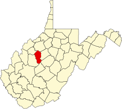
 Big Bend Location within the state of West Virginia  Big Bend Big Bend (the United States) | |
| Coordinates: 38°57′49″N81°9′42″W / 38.96361°N 81.16167°W | |
| Country | United States |
| State | West Virginia |
| County | Calhoun |
| Time zone | UTC-5 (Eastern (EST)) |
| • Summer (DST) | UTC-4 (EDT) |
| ZIP codes | 26136 |
Big Bend (shown as Bigbend on federal maps) is an unincorporated community in Calhoun County, West Virginia, United States. It lies along West Virginia Route 5 northwest of the town of Grantsville, the county seat of Calhoun County, along the Little Kanawha River. [1] Its elevation is 682 feet (208 m). [2] It has a post office with the ZIP code 26136. [3]
Big Bend was previously known as Brooksville, in honor of Preston Brooks, pro-slavery representative from South Carolina, who attacked and seriously injured Massachusetts Senator Charles Sumner. At that time it was the county seat. [4] At the end of the Civil War, and West Virginia's separation from Virginia, it was replaced by a new county seat with the name of Union General Ulysses S. Grant.