Bilberry Hill

Last updated

Bilberry Hill
Lickey Hills.jpg
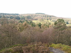
A view from Bilberry Hill over Rosehill Road and the Birmingham Municipal Golf Course towards Beacon Hill. Bilberry bushes can be seen in the foreground.
Highest point
Elevation 260 m (850 ft) [1]
Prominence 116 m (381 ft) [2]
Geography
Location Worcestershire, UK
Parent range Lickey Hills

Bilberry Hill is one of the Lickey Hills in northern Worcestershire, England, 10.3 miles (16.6 kilometres) south west of Birmingham and 24 miles (39 kilometres) north east of Worcester. It stands above and to the west of the village of Cofton Hackett, and is part of the Lickey Hills Country Park.

Contents

The three hilltops comprising The Lickeys—Bilberry Hill, Rednal Hill and Cofton Hill—form the northern extremity of the Lickey Ridge, a formation of hard quartzite. Views over Birmingham and the surrounding countryside can be seen from the top of these hills.

The hill is named after the tracts of Bilberry (Vaccinium myrtillus) bushes that cover the hill, between the pathways. Local people have been cropping the bushes of their fruit each autumn for hundreds of years to make jams, preserves or apple and bilberry pies.

History

View from Bilberry Hill looking East over Cofton Hackett village and the reservoirs Lickeys.JPG
View from Bilberry Hill looking East over Cofton Hackett village and the reservoirs

In 1888 the Birmingham Society for the Preservation of Open Spaces purchased Rednal Hill and handed it to the City in trust. In 1913 they also arranged for Bilberry Hill and Pinfold Wood to be leased to the city on a nominal peppercorn rent in perpetuity. Birmingham City Council finally purchased Cofton Hill, Lickey Warren and Pinfield Wood outright in 1920. With the eventual purchase of the Rose Hill Estate from the Cadbury family in 1923, free public access was finally restored to the entire hills with what would become the Lickey Hills Country Park in 1971.

The Bilberry Hill Centre is a hostel and sports facility, run by Birmingham Clubs for Young People, nestling at the base of Bilberry Hill. The building was donated to the people of Birmingham by Mr. and Mrs. Barrow Cadbury in 1904 as the Lickey Tea Rooms and remained in use as a restaurant until the early 1960s. The hostel can accommodate up to 65 persons. [3] In the winter of 2008 the centre was under threat of imminent closure over funding issues and there was an internet campaign to save the facility for future use by young people. [4]

Geology

A quarry cutting on Bilberry Hill through the Lickey Quartzite. Quarry cutting, Bilberry Hill.JPG
A quarry cutting on Bilberry Hill through the Lickey Quartzite.

The Lickey Hills area is of significant geological interest due to the range and age of the rocks. The darker quartzite making up Bilberry Hill shows signs of having been deposited as sand at the bottom of a shallow sea. The stratigraphic sequence, which is the basis for the area's diversity of landscape and habitat, comprises: [5]

The soil is marl and the subsoil gravel, sand and clay. There is a small quarry where Wenlock limestone was worked at the time of the making of the Worcester and Birmingham Canal, and there are some gravel-pits.

See also

Related Research Articles

<span class="mw-page-title-main">Rednal</span> Human settlement in England

Rednal is a residential suburb on the south western edge of metropolitan Birmingham, West Midlands, England, 9 miles southwest of Birmingham city centre and forming part of Longbridge parish and electoral ward.

<span class="mw-page-title-main">Lickey Hills Country Park</span> Country park in northern Worcestershire, England.

Lickey Hills Country Park is a country park in England. It is 10 miles south west of Birmingham and 24 miles north east of Worcester. The 524 acres (212 ha) park is situated just south of Rednal and close to Barnt Green. It is half a mile west of Cofton Hackett. It is one of the oldest parks managed by Birmingham City Council. The hills rise to 298 m (978 ft) above sea level at Beacon Hill.

<span class="mw-page-title-main">Clent Hills</span> Range of hills in northern Worcestershire, England.

The Clent Hills lie 10 miles (16 km) south-west of Birmingham city centre in Clent, Worcestershire, England. The closest towns are Stourbridge and Halesowen, both in the West Midlands conurbation. The Clent Hills range consists of, in order from north-west to south-east: Wychbury Hill, Clent Hill, and Walton Hill. The north Worcestershire range of hills continues eastwards to include Romsley Hill, Waseley Hills and the Lickey Hills.

<span class="mw-page-title-main">Cofton Hackett</span> Human settlement in England

Cofton Hackett is a village and civil parish in the Bromsgrove District of north east Worcestershire, England. It is 10+14 miles southwest of the city centre of Birmingham and 16 miles (26 km) northeast of Worcester. In 2011, the village had a population of 1,893 but with housing development on the former Austin Rover site, this is expected to double over the five years to 2023. The village is served by two main bus services, these being the 20 and 145/145A operated by National Express and Diamond Bus respectively.

<span class="mw-page-title-main">Lickey Hills</span> Range of hills in Worcestershire

The Lickey Hills are a range of hills in Worcestershire, England, 11 miles (18 km) to the south-west of the centre of Birmingham near the villages of Lickey, Cofton Hackett and Barnt Green. The hills are a popular country park area and they afford panoramic views over much of the surrounding countryside.

The geology of Shropshire is very diverse with a large number of periods being represented at outcrop. The bedrock consists principally of sedimentary rocks of Palaeozoic and Mesozoic age, surrounding restricted areas of Precambrian metasedimentary and metavolcanic rocks. The county hosts in its Quaternary deposits and landforms, a significant record of recent glaciation. The exploitation of the Coal Measures and other Carboniferous age strata in the Ironbridge area made it one of the birthplaces of the Industrial Revolution. There is also a large amount of mineral wealth in the county, including lead and baryte. Quarrying is still active, with limestone for cement manufacture and concrete aggregate, sandstone, greywacke and dolerite for road aggregate, and sand and gravel for aggregate and drainage filters. Groundwater is an equally important economic resource.

<span class="mw-page-title-main">Mercia Mudstone Group</span>

The Mercia Mudstone Group is an early Triassic lithostratigraphic group which is widespread in Britain, especially in the English Midlands – the name is derived from the ancient kingdom of Mercia which corresponds to that area. It is frequently encountered in older literature as the Keuper Marl or Keuper Marl Series.

<span class="mw-page-title-main">Skiddaw Group</span>

For the Skiddaw group of hills, see Skiddaw Group

The Drefach Group is an Ordovician lithostratigraphic group in west Wales. The name is derived from the village of Drefach near Meidrim in Carmarthenshire. The Group comprises the Mydrim Shales Formation, the Mydrim Limestone Formation, the Hendre Shales Formation, Asaphus Ash Formation and at its base, the underlying Felin-wen Formation.

<span class="mw-page-title-main">Llanbedrog Volcanic Group</span>

The Llanbedrog Volcanic Group is an Ordovician lithostratigraphic group in northwest Wales. The name is derived from the village of Llanbedrog on the Llyn Peninsula where the strata are exposed.

<span class="mw-page-title-main">Snowdon Volcanic Group</span>

The Snowdon Volcanic Group is an Ordovician lithostratigraphic group in Snowdonia, north-west Wales. The name is derived from Snowdon, the highest peak in Wales where it outcrops. This assemblage of rocks has also been referred to as the Snowdon Volcanic Series.

<span class="mw-page-title-main">Sherwood Sandstone Group</span>

The Sherwood Sandstone Group is a Triassic lithostratigraphic group which is widespread in Britain, especially in the English Midlands. The name is derived from Sherwood Forest in Nottinghamshire which is underlain by rocks of this age. It has economic importance as the reservoir of the Morecambe Bay gas field, the second largest gas field in the UK.

Haffield Breccia, or Clent Breccia, consist of a texturally immature compacted gravel, rich in volcanic clasts with some sedimentary rocks, in a sandy or muddy matrix, which outcrops in the English Midlands, in South Staffordshire, Birmingham and the Malverns. It is thought to have been deposited by during flash floods in rivers that were flowing through a desert, somewhere between 200 and 280 million years ago during the Permian period. The gravel consists of angular fragments, showing that they have not been transported over long distances.

<span class="mw-page-title-main">Dent Group</span>

The Dent Group is a group of Upper Ordovician sedimentary and volcanic rocks in north-west England. It is the lowermost part of the Windermere Supergroup, which was deposited in the foreland basin formed during the collision between Laurentia and Avalonia. It lies unconformably on the Borrowdale Volcanic Group. This unit was previously known as the Coniston Limestone Group or Coniston Limestone Formation and should not be confused with the significantly younger Coniston Group.

<span class="mw-page-title-main">Exmoor Group</span>

The Exmoor Group is a late Devonian to early Carboniferous lithostratigraphic group in southwest England whose outcrop extends from Croyde in north Devon east across Exmoor to Minehead in west Somerset. The group comprises the following formations the:

<span class="mw-page-title-main">Ceiswyn Formation</span> Geologic formation in Wales

The Ceiswyn Formation is an Ordovician lithostratigraphic group in Mid Wales. The rock of the formation is made up of interleaved beds of silty mudstones and siltstones with some sandstones and tuffs also present in small amounts. The formation runs diagonally across Mid Wales from close by Bala Lake to Cardigan Bay near Tywyn.

<span class="mw-page-title-main">Garnedd-Wen Formation</span>

The Garnedd-Wen Formation is an Ordovician lithostratigraphic group in Mid Wales. The rock of the formation is a mixture of mudstones, siltstones, fine- to coarse-grained sandstones, greywackes and conglomerates. The formation extends from Dinas Mawddwy in the north-east to Tywyn in the south-west.

The geology of Loch Lomond and The Trossachs National Park in the southwestern part of the Scottish Highlands consists largely of Neoproterozoic and Palaeozoic bedrock faulted and folded and subjected to low grade metamorphism during the Caledonian orogeny. These older rocks, assigned to the Dalradian Supergroup, lie to the northwest of the northeast – southwest aligned Highland Boundary Fault which defines the southern edge of the Highlands. A part of this mountainous park extends south of this major geological divide into an area characterised by younger Devonian rocks which are assigned to the Old Red Sandstone.

The geology of Exmoor National Park in south-west England contributes significantly to the character of Exmoor, a landscape which was designated as a national park in 1954. The bedrock of the area consists almost wholly of a suite of sedimentary rocks deposited during the Devonian, a period named for the English county of Devon in which the western half of the park sits. The eastern part lies within Somerset and it is within this part of the park that limited outcrops of Triassic and Jurassic age rocks are to be found.

The Ogwen Group is an Ordovician lithostratigraphic group in Gwynedd, north-west Wales. The name is derived from Ogwen Valley, a locality in Snowdonia where it outcrops.

References

  1. "OS Maps: Online mapping and walking, running and cycling routes".
  2. "Bilberry Hill". Peakbagger.
  3. "Bilberry Hill Centre". Archived from the original on 27 March 2010. Retrieved 7 January 2010.
  4. "Save the Bilbury Hill Centre". Archived from the original on 12 November 2008. Retrieved 15 November 2008.
  5. Birmingham City Council. "Lickey Hills Country Park: Geology" . Retrieved 27 March 2010.
  6. British Geological Survey. "Barnt Green Volcanic Formation". The BGS Lexicon of Named Rock Units. Retrieved 4 January 2012.
  7. British Geological Survey. "Lickey Quartzite Formation". The BGS Lexicon of Named Rock Units. Retrieved 4 January 2012.
  8. British Geological Survey. "Halesowen Formation". The BGS Lexicon of Named Rock Units. Retrieved 4 January 2012.
  9. British Geological Survey. "Clent Formation". The BGS Lexicon of Named Rock Units. Retrieved 4 January 2012.

Coordinates: 52°22′36″N2°00′37″W / 52.37664°N 2.01024°W / 52.37664; -2.01024