Niger or the Niger, officially the Republic of the Niger, is a landlocked country in West Africa. It is a unitary state bordered by Libya to the northeast, Chad to the east, Nigeria to the south, Benin and Burkina Faso to the southwest, Mali to the west, and Algeria to the northwest. It covers a land area of almost 1,270,000 km2 (490,000 sq mi), making it the second-largest landlocked country in West Africa, after Chad. Over 80% of its land area lies in the Sahara. Its predominantly Muslim population of about 25 million live mostly in clusters in the further south and west of the country. The capital Niamey is located in Niger's southwest corner.
Kanuri is a dialect continuum spoken in Nigeria, Niger, Chad and Cameroon, as well as in small minorities in southern Libya and by a diaspora in Sudan.

Zinder, formerly also spelled Sinder, is the third largest city in Niger, with a population of 170,574 ; by the 2012 census its population reached 235,605. It is situated 861 km (535 mi) east of the capital Niamey and 240 km (150 mi) north of the Nigerian city of Kano.

Sokoto is a major city located in extreme northwestern Nigeria, near the confluence of the Sokoto River and the Rima River. As of 2006 it has a population of over 427,760. Sokoto is the modern-day capital of Sokoto State and was previously the capital of the north-western states.

The culture of Niger is marked by variation, evidence of the cultural crossroads which French colonialism formed into a unified state from the beginning of the 20th century. What is now Niger was created from four distinct cultural areas in the pre-colonial era: the Djerma dominated Niger River valley in the southwest; the northern periphery of Hausaland, made mostly of those states which had resisted the Sokoto Caliphate, and ranged along the long southern border with Nigeria; the Lake Chad basin and Kaouar in the far east, populated by Kanuri farmers and Toubou pastoralists who had once been part of the Kanem-Bornu Empire; and the Tuareg nomads of the Aïr Mountains and Saharan desert in the vast north. Each of these communities, along with smaller ethnic groups like the pastoral Wodaabe Fula, brought their own cultural traditions to the new state of Niger.

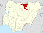
Jigawa State (Hausa: Jihar Jigawa is one of the 36 states of Nigeria, located in the northern region of the country. Created in 1991 from the northeastern-most region of Kano State, Jigawa State is located on the border with Nigeria's national border with the Republic of the Niger. The state capital and largest city is Dutse. Jigawa state has 27 local governments

Nasarawa State is a state in the North Central region of Nigeria, bordered to the east by the states of Taraba and Plateau, to the north by Kaduna State, to the south by the states of Kogi and Benue, and to the west by the Federal Capital Territory. Named for the historic Nasarawa Emirate, the state was formed from the west of Plateau State on 1 October 1996. The state has thirteen local government areas and its capital is Lafia, located in the east of the state, while a key economic centre of the state is the Karu Urban Area—suburbs of Abuja—along the western border with the FCT.
Haɗejiya is a Hausa town in eastern Jigawa State, northern Nigeria. The population was approximately 105,628 in 2006. Hadejia lies between latitude 12.4506N and longitude 10.0404E. It shared boundary with Kiri Kasama Local Government from the East, Mallam Maɗori Local Government from the North, and Auyo Local Government from the West. The Hadejia Local Government consist of eleven (11) political wards namely: Atafi, Dubantu, Gagulmari, Kasuwar Ƙofa, Kasuwar Kuda, Matsaro, Majema, Rumfa, Sabon Garu, Ƴankoli and Yayari. Inhabitant are dominantly Hausa, Fulani and Kanuri with some other groups such as Tiv, Yoruba, Igbo, Igala etc. The dominant occupation of the inhabitants is crop farming and animal rearing which a considerable percentage, engaged in trading, fishing and services including civil service. The people of Haɗeja are largely Muslims, although some follow indigenous belief systems. The town lies to the north of the Hadejia River, and is upstream from the Hadejia-Nguru wetlands. Hadejia is an internationally important ecological and sensitive zone.
The Kanembu are an ethnic group of Chad, generally considered the modern descendants of the Kanem-Bornu Empire. The Kanembu number an estimated 890,000 people, located primarily in Chad's Lac Prefecture but also in Chari-Baguirmi and Kanem prefectures. They speak the Kanembu language, which the Kanuri language is closely related to, with many speaking Arabic and sometimes nowadays French as a second language.
Faskari is a town and Local Government Area (LGA) in Katsina State, northern Nigeria. The population of the LGA was 125,181 as of 2003. The current Sarki (Emir) is Eng. Aminu Tukur Saidu, and the Executive Chairman is Honourable Bala Faskari, an APC member.

The Hausa are a native ethnic group in West and Central Africa. They speak the Hausa language, which is the second most spoken language after Arabic in the Afro-Asiatic language family. The Hausa are a diverse but culturally homogeneous people based primarily in the Sahelian and the sparse savanna areas of southern Niger and northern Nigeria respectively, numbering around 53 million people with significant indigenized populations in Benin, Cameroon, Ivory Coast, Chad, Sudan, Central African Republic, Republic of the Congo, Togo, Ghana, Eritrea, Equatorial Guinea, Gabon, Senegal and the Gambia.
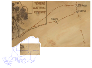
Fachi is an oasis surrounded by the Ténéré desert and the dunes of the Erg of Bilma in eastern Niger, placed on the western edge of the small Agram mountain outcropping. It has an estimated population of 2,000 people. It is also a stopping point of the Agadez to the Kaouar caravans of the Azalay. Fachi is 240 kilometres west of Bilma and 320 km (200 mi) east of the Aïr Mountains. Apart from water, dates, and salt, Fachi produces no provisions, and depends entirely upon trade in these products with passing caravans.
Jama'are is a Local Government Area of Bauchi State, Nigeria. Its headquarters are in the town of Jama'are. It has an area of 493 km2 and a population of 176,883 at the 2006 census. The postal code of the area is 751. It is populated by a Fulani tribe that migrated from Dulare in the Lake Chad basin in the Republic of Chad.
Ngala is a local government area of Borno State, Nigeria, adjacent to the border with Cameroon. Its headquarters are in the town of Gamboru Ngala.
Danja is a Local Government Area in Katsina State, Nigeria. Its headquarters are in the town of Danja.
Zangon Kataf is a Local Government Area in southern Kaduna State, Nigeria. Its headquarters is in the town of Zonkwa. It is also a name of a town in the chiefdom of the Atyap. Other towns include: Batadon (Madakiya), Cenkwon, Kamantan, Anchuna Sarki and Kamuru. It has an area of 2,579 km2 and a population of 318,991 at the 2006 census. The postal code of the area is 802.
Yauri is a Local Government Area in Kebbi State, northwestern Nigeria. It is the location of the Yauri Emirate, one of the smallest historical emirates in Northern Nigeria. In 1972, the population of the division was about 112,000 people inhabiting a land area of about 3,380 square kilometres (1,306 sq mi) and scattered over six major districts.
Saya is a Chadic dialect cluster of Nigeria.
Katangar gabari is a town in Jigawa State of Nigeria. It is located 20 km away from Kiyawa and 13 km from Dutse. town has a total population of 7000 people.
The kingdom is dominated by the Yankam people who have eventually lost their language to Hausa. located in the southern zone of plateau in Wase L.G.A is a district known Bashar.The town regard their chief as Rekna due to the history of their language. the town is known of a population of over 23,000 peaceful people. The people have made it easy for ALH. Adamu Idris to rule them for currently 57 years by uniting themselves. The history of Bashar have been tapped from different sources as expressed below.