Bischoffen

Last updated
Bischoffen
Wappen Bischoffen.png
Location of Bischoffen within Lahn-Dill-Kreis district
Lahn-Dill-Kreis Bischoffen.pngBreitscheidHerbornSinn
Germany adm location map.svg
Red pog.svg
Bischoffen
Hesse location map.svg
Red pog.svg
Bischoffen
Coordinates: 50°42′N08°23′E / 50.700°N 8.383°E / 50.700; 8.383 Coordinates: 50°42′N08°23′E / 50.700°N 8.383°E / 50.700; 8.383
Country Germany
State Hesse
Admin. region Gießen
District Lahn-Dill-Kreis
Government
   Mayor (202228) Marco Herrmann [1]
Area
  Total35.37 km2 (13.66 sq mi)
Elevation
307 m (1,007 ft)
Population
 (2020-12-31) [2]
  Total3,297
  Density93/km2 (240/sq mi)
Time zone UTC+01:00 (CET)
  Summer (DST) UTC+02:00 (CEST)
Postal codes
35649
Dialling codes 06444
Vehicle registration LDK
Website www.bischoffen.de

Bischoffen is a municipality in the Lahn-Dill-Kreis in Hesse, Germany.

Contents

Geography

Location

Bischoffen lies in the Lahn-Dill Highland at the Aar Dam (Aartalsperre). This dam holds back the river Aar, a tributary to the Dill, forming a 57-ha lake whose purpose is mainly flood control, although of course it also has its recreational uses.

Niederweidbach with the Marienkirche Kirche Niederweidbach.jpg
Niederweidbach with the Marienkirche

Niederweidbach

Lying among the villages of Bischoffen (itself a constituent community, and indeed the community's namesake, but not the biggest centre therein), Oberweidbach, Roßbach, Mudersbach and Ahrdt, Niederweidbach is found right on the shore of the Aartalsee, the man-made lake created by the Aar Dam. It is also on the stretch of Federal Highway (Bundesstraße) B 255 between Herborn and Gladenbach.

q.v. Niederweidbach's history

Neighbouring communities

Bischoffen borders in the north on the community of Bad Endbach and the town of Gladenbach, in the east on the community of Lohra (all three in Marburg-Biedenkopf), in the southeast on the community of Biebertal (Gießen district), in the south on the community of Hohenahr, in the southwest on the community of Mittenaar, and in the west on the community of Siegbach (all three in the Lahn-Dill-Kreis).

Constituent communities

The community consists of the centres of Bischoffen, Niederweidbach, Oberweidbach, Roßbach and Wilsbach.

Niederweidbach is Bischoffen's biggest community, and its administrative seat.

History

Niederweidbach and Oberweidbach were mentioned in the Fulda Monastery's Codex Eberhardi quite early on, in 802. The other communities' first documentary mentions followed lin the late 13th or early 14th century. The villages belonged to various ecclesiastical and secular rulers, but a great deal of the current municipal area came to be part of the County of Solms as time went by, through estate division, pledges and feuds.

Among the four local powers, namely the Landgraves of Hesse, the Electors of Mainz, the Free Imperial City of Wetzlar and the Counts of Nassau, the political climate was seldom calm. In the Thirty Years' War, the inhabitants suffered neediness, hardship and destruction. The villages only slowly recovered from all this.

Today's Bischoffen was, in the Middle Ages, split into the two municipalities of Oberbischoffen and Niederbischoffen (Ober– = Upper; Nieder– = Lower). Oberbischoffen died out during the Plague and other epidemics and was forsaken. Niederbischoffen was then, in later documents, called simply Bischoffen. Bischoffen earned itself special importance with the building of the Cologne-Leipzig commercial road, along whose route the Aar-Salzböde railway and Federal Highway (Bundesstraße) B 255 were later built.

With the onset of the 19th century, the area was once again divided: Bischoffen, Niederweidbach and Roßbach passed to the Grand Duchy of Hesse, and Ahrdt and Mudersbach to the Kingdom of Prussia. Up until municipal reform in 1972, the community's outlying centres belonged to the Biedenkopf district, but given their location and economic orientation, they were assigned to the new Lahn-Dill-Kreis.

Niederweidbach's history

After its first documentary mention in the Codex Eberhardi in 802 as "Weidenbach", the village was divided into two, Oberweidbach and Niederweidbach, in the 14th century, much as had been done with neighbouring Bischoffen. In 1432, the villages were granted to the House of Solms-Hohensolms, and passed to the Count of Solms-Hohensolms in 1606. As of 1628, they belonged to the Landgraviate of Hesse-Darmstadt.

Politics

Municipal council

The municipal elections on 26 March 2006 yielded the following results:

CDU 9 seats
FWG7 seats
SPD 4 seats
Kommunal Direkt3 seats

Note: FWG is a citizens' coalition.

Coat of arms

Bischoffen's civic coat of arms might heraldically be described thus: A bend wavy argent, above, in azure the crook of a bishop's crozier sinister Or, below, in vert an inverted scallop shell Or.

The wavy bend stands for the river Aar, which flows through the community. The crook stands for the community's name (from German Bischofbishop). The scallop shell stands for Saint James the Great, Niederweidbach's patron saint, whose traditional symbol is this shell.

Sightseeing

Marienkirche

The wall tower in Niederweidbach, built out of parts of the town wall, itself built in the 11th century, was converted into a chapel – as Niederweidbach belonged to Altenkirchen Parish – by the Reverend Hartong, and further expanded in 1498 on the west side with a proper church nave.

Literature

Related Research Articles

Lahn-Dill is a Kreis (district) in the west of Hesse, Germany. Neighboring districts are Siegen-Wittgenstein, Marburg-Biedenkopf, Gießen, Wetteraukreis, Hochtaunuskreis, Limburg-Weilburg, Westerwaldkreis.

Marburg-Biedenkopf is a Kreis (district) in the west of Hesse, Germany. Neighboring districts are Waldeck-Frankenberg, Schwalm-Eder, Vogelsbergkreis, Gießen, Lahn-Dill, Siegen-Wittgenstein.

<span class="mw-page-title-main">Dautphetal</span> Municipality in Hesse, Germany

Dautphetal is a community in Hesse, Germany, and is among the six larger communities of the 22 in Marburg-Biedenkopf district.

<span class="mw-page-title-main">Lahntal</span> Municipality in Hesse, Germany

The community of Lahntal is found in the Marburg-Biedenkopf district in northwest Middle Hesse, Germany.

<span class="mw-page-title-main">Leun</span> Town in Hesse, Germany

Leun is a small town in the Lahn-Dill-Kreis in Hesse, Germany.

<span class="mw-page-title-main">Angelburg</span> Municipality in Hesse, Germany

Angelburg is a community in western Marburg-Biedenkopf in northwest Middle Hesse in Germany.

<span class="mw-page-title-main">Gladenbach</span> Town in Hesse, Germany

Gladenbach [German pronunciation: [ˈɡlaːdn̩ˌbax](listen)] is a town in Hesse, Germany, in the west of Marburg-Biedenkopf district.

<span class="mw-page-title-main">Lohra, Germany</span> Municipality in Hesse, Germany

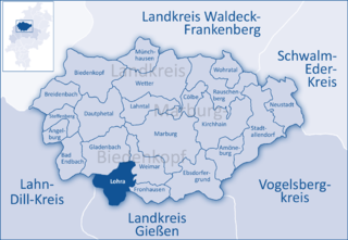
Lohra is a community in Marburg-Biedenkopf district in the administrative region of Gießen in Hesse, Germany.

<span class="mw-page-title-main">Bad Endbach</span> Municipality in Hesse, Germany

Bad Endbach is the westernmost municipality in Marburg-Biedenkopf district of the state of Hesse in Germany, and borders on the Lahn-Dill district.

<span class="mw-page-title-main">Dill (river)</span> River in Germany

The Dill is a 55 km (34 mi) long river, flowing through central Hesse in Germany. It is a tributary to the Lahn, joining it on the right bank at the town of Wetzlar.

<span class="mw-page-title-main">Dietzhölztal</span> Municipality in Hesse, Germany

The municipality of Dietzhölztal is the northernmost municipality in the Lahn-Dill-Kreis in Hesse, Germany.

<span class="mw-page-title-main">Hohenahr</span> Municipality in Hesse, Germany

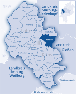
Hohenahr is a municipality in the Lahn-Dill-Kreis in Hesse, Germany.

<span class="mw-page-title-main">Mittenaar</span> Municipality in Hesse, Germany

Mittenaar is a municipality in the Lahn-Dill-Kreis in Hesse, Germany.

<span class="mw-page-title-main">Schöffengrund</span> Municipality in Hesse, Germany

Schöffengrund is a community in the Lahn-Dill-Kreis in Hesse, Germany.

<span class="mw-page-title-main">Siegbach</span> Municipality in Hesse, Germany

Siegbach is a municipality in the Lahn-Dill-Kreis in Hesse, Germany.

<span class="mw-page-title-main">Sinn, Hesse</span> Municipality in Hesse, Germany

Sinn is a community in Middle Hesse, Germany, in the Lahn-Dill-Kreis.

<span class="mw-page-title-main">Gladenbach Uplands</span>

The Gladenbach Uplands, named after their central town of Gladenbach, is a range of hills up to 609 m high in the Rhine Massif in Germany, on the junction of the Rothaar Mountains, Westerwald (southwest), (Eastern) Hintertaunus and West Hesse Highlands in the east. It lies in Central Hesse within the districts of Marburg-Biedenkopf, Lahn-Dill and Gießen within the so-called Lahn-Dill-(Dietzhölze-) loop. Small parts of the Upper Lahn Valley in the northwest belong, together with the town of Bad Laasphe, also to the district of Siegen-Wittgenstein, North Rhine-Westphalia.

<span class="mw-page-title-main">Aar Dam</span> Dam in Lahn-Dill-Kreis

The Aar Dam and its reservoir, the Aartalsee, lie in the upper Aar valley in the German state of Hesse. Both are in the municipalities of Bischoffen and Hohenahr in the county of Lahn-Dill-Kreis and about 15 km northwest of the town of Gießen in Hesse. On the lakeshores lie the villages of Ahrdt and Mudersbach, both part of the parish of Hohenahr. Since 1991 the dam has impounded the River Aar, a left-hand tributary of the Dill in the Gladenbach Uplands. The reservoir is also fed by the Stadterbach, Wilsbach, Weidbach and Meerbach.

<span class="mw-page-title-main">Hessian Hinterland</span>

The land known as the Hessian Hinterland lies within the region of Middle Hesse and is concentrated around the old county of Biedenkopf, that is the western part of the present county of Marburg-Biedenkopf, as well as elements of the present-day counties of Lahn-Dill-Kreis and Waldeck-Frankenberg. Formerly it snaked its way from Bromskirchen in the north to Rodheim, in the municipality of Biebertal.

References

  1. "Ergebnisse der letzten Direktwahl aller hessischen Landkreise und Gemeinden" (XLS) (in German). Hessisches Statistisches Landesamt. 5 September 2022.
  2. "Bevölkerung in Hessen am 31.12.2020 nach Gemeinden". Hessisches Statistisches Landesamt (in German). June 2021.