Siegbach

Last updated
Siegbach
Wappen Siegbach.svg
Location of Siegbach within Lahn-Dill-Kreis district
Lahn-Dill-Kreis Siegbach.pngBreitscheidHerbornSinn
Germany adm location map.svg
Red pog.svg
Siegbach
Hesse location map.svg
Red pog.svg
Siegbach
Coordinates: 50°44′N08°25′E / 50.733°N 8.417°E / 50.733; 8.417 Coordinates: 50°44′N08°25′E / 50.733°N 8.417°E / 50.733; 8.417
Country Germany
State Hesse
Admin. region Gießen
District Lahn-Dill-Kreis
Government
   Mayor (202127) Maik Trumpfheller [1]
Area
  Total29.08 km2 (11.23 sq mi)
Elevation
350 m (1,150 ft)
Population
 (2020-12-31) [2]
  Total2,541
  Density87/km2 (230/sq mi)
Time zone UTC+01:00 (CET)
  Summer (DST) UTC+02:00 (CEST)
Postal codes
35768
Dialling codes 02778
Vehicle registration LDK
Website www.siegbach.de

Siegbach is a municipality in the Lahn-Dill-Kreis in Hesse, Germany.

Contents

Geography

Location

The community of Siegbach lies in the Lahn-Dill Highland in the valley of its namesake brook, the Siegbach, which empties into the Aar to the south at Bischoffen.

More than half of the municipal area is wooded.

Neighbouring communities

Siegbach borders in the north on the communities of Eschenburg (Lahn-Dill-Kreis) and Angelburg, in the south on the communities of Bischoffen and Mittenaar, in the southwest on the town of Herborn, and in the west on the town of Dillenburg (all in the Lahn-Dill-Kreis).

Constituent communities

The community consists of the five centres of Eisemroth (administrative seat), Oberndorf, Tringenstein, Übernthal and Wallenfels.

History

As part of Hesse's municipal reforms, the formerly independent municipalities of Eisemroth, Tringenstein, Übernthal and Wallenfels merged on 1 January 1972 to form the greater community of Siegbach, after the communities of Oberndorf and Eisemroth had already been united for a year. The new community's namesake is the brook in whose valley the greater part of the community lies.

Within the municipal area once stood three castles, namely in Eisemroth (on whose site a church now stands), Wallenfels and Tringenstein. They came into being during the "Hundred Years' Dernbacher Feud", which was hard-fought in this area. It was a struggle waged between 1233 and 1333 between the Lords of Dernbach and the ambitious Counts of Nassau, who eventually won. [3]

Politics

Coat of arms

Siegbach's civic coat of arms might heraldically be described thus: In vert on ground Or a mine gallery sable with framework Or, therein, a crossed hammer and pick (the traditional mining tools or Gezähe ) argent.

The arms refer to the municipal area's former mining industry.

Sightseeing

The Wilhelmsteine ("William's Stones"), lying between Tringenstein and Wallenfels, are a group of pyrite monadnocks in the middle of the Schelderwald (a foothill of the Rothaargebirge range). Every year on Ascension Day, the Wilhelmsteine serve as a local pilgrimage place. A religious service is performed among them on this day.

The Wilhelmsteine, named after Count Wilhelm of Nassau, were in earlier times known as the Buschsteine. They were presumably the pre-Christian central holy place of the whole surrounding area. Nearby, at the Angelburg, from the early to high Middle Ages was an important crossroads of old long-distance trade roads. The Hohe Straße (High Road) or as it was also known Herborner Straße (Herborn Road) coming from the northeast crossed the great east-west trade road there, the Brabant Road, which ran from Leipzig by way of Cologne to the province of Brabant (nowadays in Belgium). Locally, it was also known as the Schelderwald Weg, and in old documents as strada publica (the public road). The Westfalen Weg (Westphalia Way) also joined the knot of log-distance roads here, following more or less today's Highway L3047 up to the Zollbuche ("Customs Beech" – a tree that marked a border in days of yore), and then reaching the Angelburg by way of Günterod and Salzbödesattel. Continuing north on this route, one could reach Bremen.

At the Angelburg, evidence of an important prehistoric settlement has been found.

Castle ruins can be found at Tringenstein and Wallenfels (only rubble heaps and dry moats).

Related Research Articles

<span class="mw-page-title-main">Herborn, Hesse</span> Town in Hesse, Germany

Herborn is a historic town on the Dill in the Lahn-Dill district of Hesse in Germany. Before World War I, it was granted its own title as Nassauisches Rothenburg. The symbol or mascot of this town is a bear. Scenic attractions include its half-timbered houses; Herborn is located on the German Timber-Frame Road. Herborn hosted the 26th Hessentag state festival in 1986, and the 56th Hessentag in 2016.

Lahn-Dill is a Kreis (district) in the west of Hesse, Germany. Neighboring districts are Siegen-Wittgenstein, Marburg-Biedenkopf, Gießen, Wetteraukreis, Hochtaunuskreis, Limburg-Weilburg, Westerwaldkreis.

<span class="mw-page-title-main">Dillenburg</span> Town in Hesse, Germany

Dillenburg, officially Oranienstadt Dillenburg, is a town in Hesse's Gießen region in Germany. The town was formerly the seat of the old Dillkreis district, which is now part of the Lahn-Dill-Kreis.

<span class="mw-page-title-main">Eschenburg</span> Municipality in Hesse, Germany

Eschenburg is a community in the Lahn-Dill-Kreis in Hesse, Germany. The community inherited its name from nearby Eschenburg mountain.

<span class="mw-page-title-main">Angelburg</span> Municipality in Hesse, Germany

Angelburg is a community in western Marburg-Biedenkopf in northwest Middle Hesse in Germany.

<span class="mw-page-title-main">Gladenbach</span> Town in Hesse, Germany

Gladenbach [German pronunciation: [ˈɡlaːdn̩ˌbax](listen)] is a town in Hesse, Germany, in the west of Marburg-Biedenkopf district.

<span class="mw-page-title-main">Bad Endbach</span> Municipality in Hesse, Germany

Bad Endbach is the westernmost municipality in Marburg-Biedenkopf district of the state of Hesse in Germany, and borders on the Lahn-Dill district.

<span class="mw-page-title-main">Steffenberg</span> Municipality in Hesse, Germany

Steffenberg is a municipality in Marburg-Biedenkopf district in Hesse, Germany.

<span class="mw-page-title-main">Bischoffen</span> Municipality in Hesse, Germany

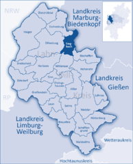
Bischoffen is a municipality in the Lahn-Dill-Kreis in Hesse, Germany.

<span class="mw-page-title-main">Breitscheid, Hesse</span> Municipality in Hesse, Germany

Breitscheid is a municipality in the Lahn-Dill-Kreis in Hesse, Germany.

<span class="mw-page-title-main">Driedorf</span> Municipality in Hesse, Germany

Driedorf is a municipality in the Lahn-Dill-Kreis in Hesse, Germany.

<span class="mw-page-title-main">Ehringshausen</span> Municipality in Hesse, Germany

Ehringshausen is a municipality in the Lahn-Dill-Kreis in Hesse, Germany.

<span class="mw-page-title-main">Hohenahr</span> Municipality in Hesse, Germany

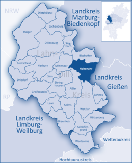
Hohenahr is a municipality in the Lahn-Dill-Kreis in Hesse, Germany.

<span class="mw-page-title-main">Mittenaar</span> Municipality in Hesse, Germany

Mittenaar is a municipality in the Lahn-Dill-Kreis in Hesse, Germany.

<span class="mw-page-title-main">Schöffengrund</span> Municipality in Hesse, Germany

Schöffengrund is a community in the Lahn-Dill-Kreis in Hesse, Germany.

<span class="mw-page-title-main">Sinn, Hesse</span> Municipality in Hesse, Germany

Sinn is a community in Middle Hesse, Germany, in the Lahn-Dill-Kreis.

<span class="mw-page-title-main">Waldsolms</span> Municipality in Hesse, Germany

Waldsolms is a community located in the Lahn-Dill-Kreis in Hesse, Germany.

<span class="mw-page-title-main">Mengerskirchen</span> Municipality in Hesse, Germany

Mengerskirchen is a municipality in Limburg-Weilburg district in Hesse, Germany.

The Dernbach Feud was an over 100-year-long ongoing dispute in present-day Germany between the House of Nassau, several knightly families, and the Landgrave of Hesse. The conflict erupted mainly over property rights in Herborn and the surrounding area.

References

  1. "Ergebnisse der letzten Direktwahl aller hessischen Landkreise und Gemeinden" (XLS) (in German). Hessisches Statistisches Landesamt. 5 September 2022.
  2. "Bevölkerung in Hessen am 31.12.2020 nach Gemeinden". Hessisches Statistisches Landesamt (in German). June 2021.
  3. Burg Dernbach