Breitscheid, Hesse

Last updated
Breitscheid
Wappen Breitscheid (Hessen).png
Location of Breitscheid within Lahn-Dill-Kreis district
Lahn-Dill-Kreis Breitscheid.pngBreitscheidHerbornSinn
Germany adm location map.svg
Red pog.svg
Breitscheid
Hesse location map.svg
Red pog.svg
Breitscheid
Coordinates: 50°41′N08°12′E / 50.683°N 8.200°E / 50.683; 8.200 Coordinates: 50°41′N08°12′E / 50.683°N 8.200°E / 50.683; 8.200
Country Germany
State Hesse
Admin. region Gießen
District Lahn-Dill-Kreis
Government
   Mayor (201925) Roland Lay [1]
Area
  Total31.74 km2 (12.25 sq mi)
Elevation
462 m (1,516 ft)
Population
 (2020-12-31) [2]
  Total4,672
  Density150/km2 (380/sq mi)
Time zone UTC+01:00 (CET)
  Summer (DST) UTC+02:00 (CEST)
Postal codes
35767
Dialling codes 02777
Vehicle registration LDK
Website www.gemeinde-breitscheid.de

Breitscheid is a municipality in the Lahn-Dill-Kreis in Hesse, Germany.

Contents

Geography

Location

Breitscheid lies from 266 to 600 m above sea level on the eastern slope of the Westerwald range at the point shared by three German states: Hesse, Rhineland-Palatinate and North Rhine-Westphalia.

Panorama of Erdbach. Erdbach.jpg
Panorama of Erdbach.

Erdbach, a constituent community, lies in an interesting place with regards to Earth's history, in the eastern part of the Westerwald, near that range's highest peak, Fuchskauten (657 m).

Geology

In the Erdbach area are noteworthy limestone deposits from various geological time periods. "Erdbach limestone" from Lower Carboniferous times gave an era the name "Erdbachium". The Erdbach – the village's namesake brook – disappears into a karst system, and does not appear again for 1.5 km where it can be seen in a quarry.

Not far from there, the "Homberg" fossil reserve was instituted, which serves some university institutes from Jena to the Rhine as a research area. The older limestone formation near Breitscheid (main centre) stems from a subtropical coral reef from the Devonian period (mid-Palaeozoic, 400,000,000 years ago).

In the "stone chambers" of the Rolsbach valley, some gravesites from Hallstatt times (about 550 BC) were unearthed in 1884. In archaeology, there is a special burial ornament called an "Erdbach coil torc" (Erdbacher Wendelhalsring). It is also believed that Neanderthal people once lived nearby, but this belief awaits further discovery.

Neighbouring communities

Breitscheid borders in the north on the community of Burbach (Siegen-Wittgenstein district in North Rhine-Westphalia), and the towns of Haiger and Dillenburg, in the east on the town of Herborn, in the south on the community of Driedorf (all in the Lahn-Dill-Kreis), and in the west on the communities of Willingen and Liebenscheid (both in the Westerwaldkreis in Rhineland-Palatinate).

Constituent communities

Aside from the main centre, which bears the same name as the whole, there are outlying centres called Erdbach, Gusternhain, Medenbach and Rabenscheid. The community came into being on 1 January 1977 as part of Hesse's municipal reforms. The constituent communities were formerly independent municipalities.

Politics

Municipal council

The municipal elections on 26 March 2006 yielded the following results:

FWG9 seats
CDU 9 seats
SPD 5 seats

Note: FWG is a citizens' coalition.

Main sights

Related Research Articles

<span class="mw-page-title-main">Westerwald</span> Mountain range in Germany

The Westerwald is a low mountain range on the right bank of the river Rhine in the German federal states of Rhineland-Palatinate, Hesse and North Rhine-Westphalia. It is a part of the Rhenish Massif. Its highest elevation, at 657 m above sea level, is the Fuchskaute in the High Westerwald.

Rheingau-Taunus is a Kreis (district) in the west of Hesse, Germany. Rheingau-Taunus-Kreis is part of the Darmstadt region; its main administrative seat is Bad Schwalbach. Outposted sections of the local administration are located in Idstein and Rüdesheim am Rhein.

Lahn-Dill is a Kreis (district) in the west of Hesse, Germany. Neighboring districts are Siegen-Wittgenstein, Marburg-Biedenkopf, Gießen, Wetteraukreis, Hochtaunuskreis, Limburg-Weilburg, Westerwaldkreis.

Limburg-Weilburg is a Kreis (district) in the west of Hesse, Germany. Neighboring districts are Lahn-Dill, Hochtaunuskreis, Rheingau-Taunus, Rhein-Lahn, Westerwaldkreis.

The Westerwaldkreis is a district (Kreis) in the north-east of Rhineland-Palatinate, Germany. Neighbouring districts are Altenkirchen, Lahn-Dill, Limburg-Weilburg, Rhein-Lahn, the district-free city Koblenz, Mayen-Koblenz and Neuwied.

<span class="mw-page-title-main">Dillenburg</span> Town in Hesse, Germany

Dillenburg, officially Oranienstadt Dillenburg, is a town in Hesse's Gießen region in Germany. The town was formerly the seat of the old Dillkreis district, which is now part of the Lahn-Dill-Kreis.

<span class="mw-page-title-main">Gladenbach</span> Town in Hesse, Germany

Gladenbach [German pronunciation: [ˈɡlaːdn̩ˌbax](listen)] is a town in Hesse, Germany, in the west of Marburg-Biedenkopf district.

<span class="mw-page-title-main">Haiger</span> Town in Hesse, Germany

Haiger is a country town in the Lahn-Dill-Kreis in Hesse, Germany. The nearest city is Siegen, about 25 km north of Haiger.

<span class="mw-page-title-main">Aßlar</span> Town in Hesse, Germany

Aßlar is a town near Wetzlar in the Lahn-Dill-Kreis in Hesse, Germany.

<span class="mw-page-title-main">Dietzhölztal</span> Municipality in Hesse, Germany

The municipality of Dietzhölztal is the northernmost municipality in the Lahn-Dill-Kreis in Hesse, Germany.

<span class="mw-page-title-main">Driedorf</span> Municipality in Hesse, Germany

Driedorf is a municipality in the Lahn-Dill-Kreis in Hesse, Germany.

<span class="mw-page-title-main">Hohenahr</span> Municipality in Hesse, Germany

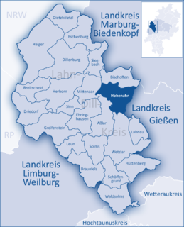
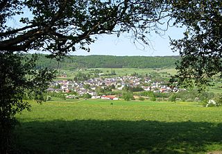
Hohenahr is a municipality in the Lahn-Dill-Kreis in Hesse, Germany.

<span class="mw-page-title-main">Siegbach</span> Municipality in Hesse, Germany

Siegbach is a municipality in the Lahn-Dill-Kreis in Hesse, Germany.

<span class="mw-page-title-main">Sinn, Hesse</span> Municipality in Hesse, Germany

Sinn is a community in Middle Hesse, Germany, in the Lahn-Dill-Kreis.

<span class="mw-page-title-main">Löhnberg</span> Municipality in Hesse, Germany

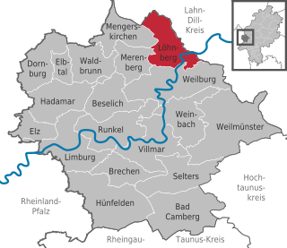
Löhnberg is a municipality north of Weilburg in Limburg-Weilburg district in Hesse, Germany.

<span class="mw-page-title-main">Heidenrod</span> Municipality in Hesse, Germany

Heidenrod is a municipality in the Rheingau-Taunus-Kreis in the Regierungsbezirk of Darmstadt in Hesse, Germany. Seat of municipal administration is to be found in the most populated municipal district, in Laufenselden.

<span class="mw-page-title-main">Rehe, Germany</span> Municipality in Rhineland-Palatinate, Germany

Rehe is an Ortsgemeinde – a community belonging to a Verbandsgemeinde – in the Westerwaldkreis in Rhineland-Palatinate, Germany.

<span class="mw-page-title-main">Langenaubach</span> Stadtteil of Haiger in Hesse, Germany

Langenaubach is a village and a Stadtteil of Haiger in the Lahn-Dill-Kreis district in Hesse in Germany.

References

  1. "Ergebnisse der letzten Direktwahl aller hessischen Landkreise und Gemeinden" (XLS) (in German). Hessisches Statistisches Landesamt. 5 September 2022.
  2. "Bevölkerung in Hessen am 31.12.2020 nach Gemeinden". Hessisches Statistisches Landesamt (in German). June 2021.