Burbach, North Rhine-Westphalia

Last updated
Burbach
Burbach Siegerland.jpg
Burbach seen from the northwest
DEU Burbach (Siegerland) COA.svg
Location of Burbach within Siegen-Wittgenstein district
Burbach in SI.svgBurbachNeunkirchenFreudenberg
Germany adm location map.svg
Red pog.svg
Burbach
North Rhine-Westphalia location map 01.svg
Red pog.svg
Burbach
Coordinates: 50°44′40″N8°05′10″E / 50.74444°N 8.08611°E / 50.74444; 8.08611 Coordinates: 50°44′40″N8°05′10″E / 50.74444°N 8.08611°E / 50.74444; 8.08611
Country Germany
State North Rhine-Westphalia
Admin. region Arnsberg
District Siegen-Wittgenstein
Subdivisions9
Government
   Mayor (202025) Christoph Ewers [1] (CDU)
Area
  Total79.66 km2 (30.76 sq mi)
Elevation
365 m (1,198 ft)
Population
 (2020-12-31) [2]
  Total14,913
  Density190/km2 (480/sq mi)
Time zone UTC+01:00 (CET)
  Summer (DST) UTC+02:00 (CEST)
Postal codes
57299
Dialling codes 02736
Vehicle registration SI
Website www.burbach-siegerland.de

Burbach is a municipality in the Siegen-Wittgenstein district, in North Rhine-Westphalia, Germany.

Contents

Geography

Burbach is located in Siegen-Wittgenstein district on the river Heller, about 15 km south of Siegen. Burbach also is a community in the southern part of the state Northrhine Westphalia.

Constituent divisions

Constituent communities Stadtgliederung Burbach (Siegerland).png
Constituent communities

The community of Burbach consists of the following subdivisions: Burbach, Gilsbach, Holzhausen, Lippe, Lützeln, Niederdresselndorf, Oberdresselndorf, Wahlbach, Würgendorf.

Politics

Municipal council

The council's 32 seats are apportioned thus, in accordance with municipal elections held on 25 May 2014:

Coat of arms

Burbach's civic coat of arms might heraldically be described thus: Party per pale, dexter in azure spangled with billets Or a two-tailed lion rampant Or armed and langued gules, sinister in Or three lozenges sable arranged vertically.

The lion stands for the princely House of Nassau-Siegen. The three lozenges (diamonds) come from the Lords of Seelbach, who held sway over the community in the Middle Ages.

The current civic coat of arms is based on the now abolished Amt's arms, and was granted in 1970. The local court for Burbach and Seelbach was already using the combination of a lion and diamonds by the 15th century.

Economy and infrastructure

Transport

Running through the northeast of the municipal area is Autobahn A 45 (Sauerlandlinie). As well, the municipal area is connected in the east to Federal Highway (Bundesstraße) B 54, which runs from Siegen towards Limburg an der Lahn. Bus connections are provided by the Westphalia-South Transport Community (Verkehrsgemeinschaft Westfalen-Süd; VGWS) running to all neighbouring communities.

The community is directly connected to the Deutsche Bahn railway network by the Hellertalbahn railway running from Haiger to Betzdorf.

In the southern municipal area lies the Siegerland Airport.

Established businesses

Well known businesses in Burbach are:

Notable people

Notable people associated with the town include:

Related Research Articles

<span class="mw-page-title-main">Westphalia</span> State part and historic region of North Rhine-Westphalia, Germany

Westphalia is a region of northwestern Germany and one of the three historic parts of the state of North Rhine-Westphalia. It has an area of 20,210 square kilometres (7,800 sq mi) and 7.9 million inhabitants.

Hochsauerlandkreis is a Kreis (district) in the east of North Rhine-Westphalia, Germany. Neighboring districts are Soest, Paderborn, Höxter, Waldeck-Frankenberg, Siegen-Wittgenstein, Olpe, Märkischer Kreis.

Olpe is a Kreis (district) in the south-east of North Rhine-Westphalia, Germany. Neighboring districts are Märkischer Kreis, Hochsauerland, Siegen-Wittgenstein, Altenkirchen, Oberbergischer Kreis.

Siegen-Wittgenstein is a Kreis (district) in the southeast of North Rhine-Westphalia, Germany. Neighboring districts are Olpe, Hochsauerlandkreis, Waldeck-Frankenberg, Marburg-Biedenkopf, Lahn-Dill, Westerwaldkreis, and Altenkirchen.

<span class="mw-page-title-main">Wenden (Sauerland)</span> Town in North Rhine-Westphalia, Germany

Wenden is a community in North Rhine-Westphalia, Germany. It belongs to the Olpe district in the Sauerland. It lies 10 kilometres south of Olpe and 20 km (12 mi) northwest of Siegen.

<span class="mw-page-title-main">Siegen</span> City in North Rhine-Westphalia, Germany

Siegen is a city in Germany, in the south Westphalian part of North Rhine-Westphalia.

<span class="mw-page-title-main">Wilnsdorf</span> Municipality in North Rhine-Westphalia, Germany

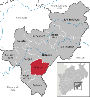
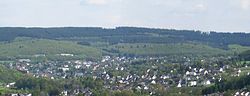
Wilnsdorf is a municipality in the district of Siegen-Wittgenstein, in North Rhine-Westphalia, Germany.

<span class="mw-page-title-main">Rösrath</span> Town in North Rhine-Westphalia, Germany

Rösrath is a town in the Rheinisch-Bergischer Kreis (district) in North Rhine-Westphalia, Germany. The earliest known documents mentioning the settlement Rösrath can be found in documents dated to 1356. There have been findings of Paleolithic and Mesolithic tools in the town area Forsbach. The community was elevated to the town status in 2001.

<span class="mw-page-title-main">Steinheim, Westphalia</span> Town in North Rhine-Westphalia, Germany

Steinheim is a town in Höxter district in North Rhine-Westphalia, Germany.

<span class="mw-page-title-main">Olpe, Germany</span> Town in North Rhine-Westphalia, Germany

Olpe is a town situated in the foothills of the Ebbegebirge in North Rhine-Westphalia, roughly 60 km east of Cologne and 20 km northwest of Siegen. It is part of the Regierungsbezirk of Arnsberg and is the seat of the district of Olpe.

<span class="mw-page-title-main">Kirchhundem</span> Town in North Rhine-Westphalia, Germany

Kirchhundem is a German community in North Rhine-Westphalia. It belongs to the Olpe district.

<span class="mw-page-title-main">Bad Berleburg</span> Place in North Rhine-Westphalia, Germany

Bad Berleburg is a town, in the district of Siegen-Wittgenstein, in North Rhine-Westphalia, Germany. It is one of Germany's largest towns by land area. It is located approximately 30 km (19 mi) northeast of Siegen and 35 km (22 mi) northwest of Marburg an der Lahn.

<span class="mw-page-title-main">Bad Laasphe</span> Town in North Rhine-Westphalia, Germany

Bad Laasphe is a town in North Rhine-Westphalia, Germany, in the Siegen-Wittgenstein district.

<span class="mw-page-title-main">Freudenberg, Westphalia</span> Town in North Rhine-Westphalia, Germany

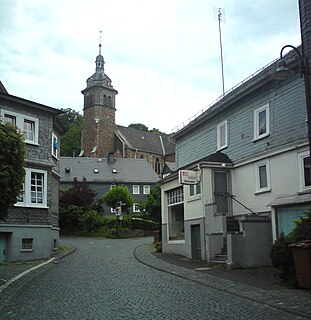
Freudenberg is a town in the Siegen-Wittgenstein district, in North Rhine-Westphalia, Germany.

<span class="mw-page-title-main">Hilchenbach</span> Town in North Rhine-Westphalia, Germany

Hilchenbach is a town in the Siegen-Wittgenstein Kreis (district) of North Rhine-Westphalia, Germany.

<span class="mw-page-title-main">Kreuztal</span> Town in North Rhine-Westphalia, Germany

Kreuztal is a town in the Siegen-Wittgenstein district, in North Rhine-Westphalia, Germany.

<span class="mw-page-title-main">Netphen</span> Town in North Rhine-Westphalia, Germany

Netphen is a town in the Siegen-Wittgenstein district, in North Rhine-Westphalia, Germany. It lies on the river Sieg, roughly 7 km northeast of Siegen.

<span class="mw-page-title-main">Erndtebrück</span> Municipality in North Rhine-Westphalia, Germany

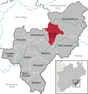
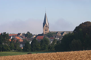
Erndtebrück is a municipality in the Siegen-Wittgenstein district, in North Rhine-Westphalia, Germany.

<span class="mw-page-title-main">Neunkirchen (Siegerland)</span> Municipality in North Rhine-Westphalia, Germany

Neunkirchen ; English: Nine Churches) is a municipality in the Siegen-Wittgenstein district, in North Rhine-Westphalia, Germany.

<span class="mw-page-title-main">Siegerland-Höhenring</span> Hiking trail going through three German federal states

Siegerland-Höhenring(Siegerland mountain ridge circular route) is an approximately 142-kilometre-long (88-mile-long) hiking trail in Germany that circles most parts of Siegerland in the districts of Siegen-Wittgenstein and Altenkirchen.

References

  1. Wahlergebnisse in NRW Kommunalwahlen 2020, Land Nordrhein-Westfalen, accessed 30 June 2021.
  2. "Bevölkerung der Gemeinden Nordrhein-Westfalens am 31. Dezember 2020" (in German). Landesbetrieb Information und Technik NRW . Retrieved 21 June 2021.