Freudenberg, Westphalia

Last updated
Freudenberg
Freudenberg Alter Flecken.jpg
The Alter Flecken. Freudenberg's historic core
DEU Freudenberg (Siegerland) COA.svg
Location of Freudenberg within Siegen-Wittgenstein district
Freudenberg in SI.svgBurbachNeunkirchenFreudenberg
Germany adm location map.svg
Red pog.svg
Freudenberg
North Rhine-Westphalia location map 01.svg
Red pog.svg
Freudenberg
Coordinates: 50°53′59″N07°52′00″E / 50.89972°N 7.86667°E / 50.89972; 7.86667 Coordinates: 50°53′59″N07°52′00″E / 50.89972°N 7.86667°E / 50.89972; 7.86667
Country Germany
State North Rhine-Westphalia
Admin. region Arnsberg
District Siegen-Wittgenstein
Subdivisions17
Government
   Mayor (202025) Nicole Reschke [1] (SPD)
Area
  Total54.48 km2 (21.03 sq mi)
Elevation
330 m (1,080 ft)
Population
 (2020-12-31) [2]
  Total17,729
  Density330/km2 (840/sq mi)
Time zone UTC+01:00 (CET)
  Summer (DST) UTC+02:00 (CEST)
Postal codes
57258
Dialling codes 02734
Vehicle registration SI
Website www.freudenberg-stadt.de

Freudenberg is a town in the Siegen-Wittgenstein district, in North Rhine-Westphalia, Germany.

Contents

The town lies on the German-Dutch holiday road called the Orange Route, joining towns, cities and regions associated with the House of Orange.

Geography

Location

Freudenberg lies in hilly uplands between 243 and 505 m above sea level. The 17 constituent communities share roughly 55 km², of which two thirds is made up of broadleaf and spruce forest.

Constituent communities

Constituent communities Stadtgliederung Freudenberg (Siegerland).png
Constituent communities

Besides the main town, which bears the same name as the whole municipality, there are sixteen outlying centres named Alchen, Bottenberg, Bühl, Büschergrund, Dirlenbach, Heisberg, Hohenhain, Lindenberg, Mausbach, Niederheuslingen, Niederholzklau, Niederndorf, Oberfischbach, Oberheuslingen, Oberholzklau and Plittershagen. Among these, the main town is the biggest, and the next in size after that is Büschergrund, which is itself further subdivided into four parts, named Büschen, Eichen, Anstoß and Bockseifen.

History

The town of Freudenberg in its current form came into being through municipal reform on 1 January 1969. Into it the seventeen formerly self-standing municipalities of Alchen, Bottenberg, Bühl, Büschergrund, Dirlenbach, Freudenberg, Heisberg, Hohenhain, Lindenberg, Mausbach, Niederheuslingen, Niederholzklau, Niederndorf, Oberfischbach, Oberheuslingen, Oberholzklau and Plittershagen were merged into one.

The oldest constituent communities are most likely the two that were both mentioned in documents in the 11th century, namely Plittershagen and Oberholzklau in 1079. Freudenberg is known to have been an Amt and court seat as of the early 15th century. The village and the castle of Freudenberg had their first documentary mention in 1389.

The castle was founded over the Weibe Valley together with a settlement by the Counts of Nassau as a corner post of their domain. Count Johann IV of Nassau, Vianden and Diez gave the Freudenberg townsfolk their "freedom rights" on 7 November 1456. This was a kind of minimal town rights, but the document bestowing this distinction upon the town is taken as evidence of town rights being granted Freudenberg. Documents give clues that Freudenberg was established quite early on as a "Flecken", or market town. The historic town core is even still called Alter Flecken (alt means "old"; –er is a grammatical inflection).

In 1540, both the castle and the town were heavily damaged by a fire. On William the Rich's orders, there came into being about the mid 16th century new building works. The market town was given a new town wall with four gates. In the northwest, the Hohenhainer Tor was built, in the northeast the Weihertor, in the southeast the Braastor and in the southwest the Schultor (Tor means "gate"). However, owing to yet another town fire on 9 August 1666, the town was once again laid waste. Prince Johann Moritz von Nassau-Siegen built the town anew, using much the same layout, planned in 1540, as had stood before the fire. The castle, however, was not restored, and to this day, all that can be seen of it are a few wall remains.

In 1969, the new, greater Freudenberg came into being with the merger of the seventeen former municipalities named herein.

Politics

Town council

The town council is elected roughly every 5 years. Its composition is listed below:

SPD CDU Greens FDP independenttotal
2020 [3] 141163034
2014 [3] 141232334
2009 [4] 121433234
2004 [5] 111722234

Coat of arms

The charge in Freudenberg's civic coat of arms is variously interpreted as a castle or a town gate. If the later is the case, it might heraldically be described thus: In azure a crenellated town gate Or with two crenellated towers Or. In either case, the town's current arms, granted in 1911 and confirmed in 1970, are based on the town's oldest known seal, from 1473. This seal's colours were not known; the blue and gold seen today are the colours of the old princely house of Nassau-Siegen.

Town partnerships

Culture and sightseeing

Theatre

Freudenberg Freudenberg-014 crop.jpg
Freudenberg

At the Südwestfälische Freilichtbühne Freudenberg (Freudenberg South Westphalian Open-air Stage), [6] before a breathtaking backdrop of forest and crags, two new productions are staged every year for children and adults. Yearly, about 50,000 visitors come to the open-air stage with its roofed grandstand.

Museums

The town museum (Stadtmuseum) has exhibits relating to local history and economic history. Especially worth seeing is the House's clock collection. The Technical Museum (Technikmuseum) has on display exhibits relating to trade and industrial history from the region. The museum's centrepiece is a steam engine built in 1904. As well, the museum has a variety of wheeled vehicles on display.

Buildings

The "Alter Flecken" is Freudenberg's downtown core, built wholly of half-timbered houses. It gives the impression of a small town from the 17th century. The Alter Flecken was included in the Kulturatlas des Landes Nordrhein-Westfalen (Cultural Atlas of the State of North Rhine-Westphalia) as a "Building monument of international importance". The Evangelical church, after Freudenberg got its own parish in 1585, was built as a "fortress church" (i.e. with architecture somewhat reminiscent of a military fortification). The belltower is the only one of the former castle's towers still left standing.

The church in Oberholzklau was built early in the 13th century and is worth seeing as a Romanesque church whose architecture nevertheless plainly shows transition to Gothic. The rectory next door, built in half-timbered style, is from 1608.

Film backdrop

The prim and proper seeming town has served in, among others, Detlev Buck's film LiebesLuder as an allegory of a decent, middle-class small town in which behind the scenes things stink. Likewise, the town served as the backdrop in the film Lupo und der Muezzin (Diana Film, Munich).

Economy and infrastructure

The town is crossed from north to southeast by Autobahn A 45. Until the 1980s, there was also a railway connection through the Biggetalbahn to Olpe in the north and through the Asdorftalbahn to Betzdorf in the south. Nowadays, a great deal of the former right-of-way has been turned into bicycle trails or filled in with earth.

Personalities

Former mayor Hermann Vomhof is at this time Freudenberg's only honorary citizen. Freudenberg is the ancestral village of Apollo XI Astronaut Buzz Aldrin, [7] a descendant of Freudenberg Burgermeister Jacob Friesenhagen, circa 1660. [8]

Sons and daughters of the city

Related Research Articles

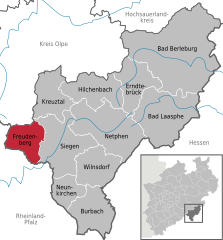
Siegen-Wittgenstein is a Kreis (district) in the southeast of North Rhine-Westphalia, Germany. Neighboring districts are Olpe, Hochsauerlandkreis, Waldeck-Frankenberg, Marburg-Biedenkopf, Lahn-Dill, Westerwaldkreis, and Altenkirchen.

Horstmar Town in North Rhine-Westphalia, Germany

Horstmar is a German town, located in North Rhine-Westphalia in the Steinfurt district, approx. 25 km (16 mi) north-west of Münster.

Siegen City in North Rhine-Westphalia, Germany

Siegen is a city in Germany, in the south Westphalian part of North Rhine-Westphalia.

Höxter Town in North Rhine-Westphalia, Germany

Höxter is a town in eastern North Rhine-Westphalia, Germany on the left bank of the river Weser, 52 km north of Kassel in the centre of the Weser Uplands. The main town's population is around 15,000, and with outlying centres, about 30,000. It is the seat of the Höxter district. Historical place names of Höxter are Hoxer and Huxaria.

Salzkotten Town in North Rhine-Westphalia, Germany

Salzkotten is a town in the district of Paderborn, in North Rhine-Westphalia, Germany. The name Salzkotten is based in the former salt production, which gave Salzkotten its raison d'être. Salt was found in the salty springs around the town.

Bad Driburg Town in North Rhine-Westphalia, Germany

Bad Driburg is a town and spa in Höxter district in North Rhine-Westphalia, Germany, situated on the river Aa and the Altenbeken–Kreiensen railway.

Bedburg-Hau Municipality in North Rhine-Westphalia, Germany

Bedburg-Hau is a municipality in the district of Kleve in the state of North Rhine-Westphalia, Germany. It is located approximately 5 km south-east of Kleve.

Lüdinghausen Town in North Rhine-Westphalia, Germany

Lüdinghausen is a town in district of Coesfeld in the state of North Rhine-Westphalia, Germany. It is located on the Dortmund-Ems Canal, approx. 25 km south-west of Münster.

Rietberg Town in North Rhine-Westphalia, Germany

Rietberg is a town in the district of Gütersloh in the state of North Rhine-Westphalia, Germany. It is located approximately 10 km south of Gütersloh and 25 km north-west of Paderborn in the region Ostwestfalen-Lippe. The town is located at the river Ems. There are 28,878 people living in Rietberg.

Schmallenberg Town in North Rhine-Westphalia, Germany

Schmallenberg is a town and a climatic health resort in the High Sauerland District, Germany. By area, it is the third biggest of all cities and towns of the state of North Rhine-Westphalia and the second biggest of the region of Westphalia.

Steinheim, Westphalia Town in North Rhine-Westphalia, Germany

Steinheim is a town in Höxter district in North Rhine-Westphalia, Germany.

Lennestadt Town in North Rhine-Westphalia, Germany

Lennestadt lies in the Sauerland in southeast North Rhine-Westphalia and is a community in Olpe district. It is the district's most populous municipality. Lennestadt itself is not an actual town but a community which comprises several towns and villages.

Hennef (Sieg) Town in North Rhine-Westphalia, Germany

Hennef (Sieg) is a town in the Rhein-Sieg district of North Rhine-Westphalia, Germany. It is situated on the river Sieg, approx. 7 kilometres south-east of Siegburg and 15 km (9 mi) east of Bonn. Hennef is the fourth-biggest town in the Rhein-Sieg-Kreis. It is the site of the 15th-century castle, Schloss Allner, next to the Allner See. Within Hennef is the town of Stadt Blankenberg, with the castle of Blankenberg.

Bad Berleburg Place in North Rhine-Westphalia, Germany

Bad Berleburg is a town, in the district of Siegen-Wittgenstein, in North Rhine-Westphalia, Germany. It is one of Germany's largest towns by land area. It is located approximately 30 km (19 mi) northeast of Siegen and 35 km (22 mi) northwest of Marburg an der Lahn.

Bad Laasphe Town in North Rhine-Westphalia, Germany

Bad Laasphe is a town in North Rhine-Westphalia, Germany, in the Siegen-Wittgenstein district.

Hilchenbach Town in North Rhine-Westphalia, Germany

Hilchenbach is a town in the Siegen-Wittgenstein Kreis (district) of North Rhine-Westphalia, Germany.

Kreuztal Town in North Rhine-Westphalia, Germany

Kreuztal is a town in the Siegen-Wittgenstein district, in North Rhine-Westphalia, Germany.

Netphen Town in North Rhine-Westphalia, Germany

Netphen is a town in the Siegen-Wittgenstein district, in North Rhine-Westphalia, Germany. It lies on the river Sieg, roughly 7 km northeast of Siegen.
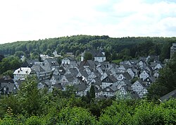
Burbach, North Rhine-Westphalia Municipality in North Rhine-Westphalia, Germany

Burbach is a municipality in the Siegen-Wittgenstein district, in North Rhine-Westphalia, Germany.

Niederholzklau is a constituent community of Freudenberg, Siegen-Wittgenstein, North Rhine-Westphalia, Germany.

References

  1. Wahlergebnisse in NRW Kommunalwahlen 2020, Land Nordrhein-Westfalen, accessed 30 June 2021.
  2. "Bevölkerung der Gemeinden Nordrhein-Westfalens am 31. Dezember 2020" (in German). Landesbetrieb Information und Technik NRW . Retrieved 21 June 2021.
  3. 1 2 Endgültiges Ergebnis für die Stadt-/Gemeinderatswahl: Freudenberg, Stadt
  4. Ratswahl Stadt Freudenberg 30.08.2009
  5. Ratswahl Stadt Freudenberg 26.09.2004
  6. Südwestfälische Freilichtbühne Freudenberg
  7. Archived 2009-08-02 at the Wayback Machine "Brigitte Wambsganß, “Buzz Aldrin: Mond-Mann mit Trupbacher Wurzeln,” Der Westen (Germany), July 17, 2009."
  8. Ancestry of Buzz Aldrin