Bishangarh

Last updated

Kailash Dham Bishangarh.jpg
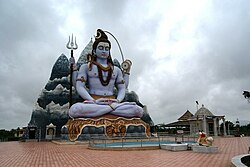
Kailash Dham, Bishangarh
Nickname: 
Twin City of Jalore
Coordinates: 25°26′N72°34′E / 25.44°N 72.56°E / 25.44; 72.56
Country Flag of India.svg  India
State Rajasthan
Division Pali
District Jalore
Sub-district Bishangarh
Government
  Type Municipal Council
  BodyBishangarh Nagar Palika (Gram Panchayat)
   Member of Parliament Devji Patel (BJP)
   Member of Legislative Assembly Jogeshwar Garg (BJP)
  Collector & DMIndian Administrative Service
Elevation
148.38 m (486.81 ft)
Population
 (2021 Census) [1] [ dead link ]
  Total10,000+
Demonym Marwari
Languages
  Official Marwari, Hindi, English
Time zone UTC+5:30 (IST)
PIN
343042
Vehicle registration RJ-16
Nearest city Jalore
Lok Sabha constituency Jalore
Vidhan Sabha constituency Jalore

Bishangarh is a village in the Indian state of Rajasthan. [2] [3] It is the twin city of Jalore.[ citation needed ] It was historically part of the Kingdom of Marwar, which is now part of Rajasthan. Bishangarh is expected to become the administrative headquarters of the Bishangarh Tehsil, including more than 26 villages and towns.

Geography

According to Census 2011 information Bishangarh is located in Jalore district in Rajasthan, Bharat. It is situated 16km away from Jalore, which is district headquarter of Bishangarh. As per 2009 stats, Bishangarh was also a gram panchayat. [2]

The total geographical area of Bishangarh is 1979.07 hectares. Bishangarh has a total population of 4,074 peoples, out of which male population is 2,039+ while female population is 2,035+.[ citation needed ] Literacy rate of Bishangarh is 54.37% out of which 65.87% males and 42.85% females are literate. There are about 716+ houses in Bishangarh. Pincode of Bishangarh locality is 343042. [2]

Jalore is nearest town to Bishangarh for all major economic activities, which is approximately 16km away.

Related Research Articles

Jalore, also known as Granite City, is a city in the western Indian state of Rajasthan. It is the administrative headquarters of Jalore District.

<span class="mw-page-title-main">Sawai Madhopur district</span> District of Rajasthan in India

Sawai Madhopur district is a district of Rajasthan state in north-west India. Sawai Madhopur is the chief town and district headquarters. Sawai Madhopur district comes under Bharatpur division.

<span class="mw-page-title-main">Barmer district</span> District of Rajasthan in India

Barmer District is a district in Rajasthan state of India. It is located in the western part of Rajasthan state forming a part of the Thar Desert. Barmer is the third largest district by area in Rajasthan and fifth largest district in India. Occupying an area of 28,387 km2. Being in the western part of the state, it includes a part of the Thar Desert. Jaisalmer is to the north of this district while Jalore is in its south. Pali and Jodhpur form its eastern border and it shares a border with Pakistan in the west. Partially being a desert, this district has a large variation in temperature. The temperature in summer can rise up to 51 °C and falls near to 0 °C in winter. Luni is the longest river in Barmer district. After travelling a length of almost 500 km, it passes through Jalore and merges in the marshy land of Runn of Kutch. District headquarters is in the town of Barmer. The other major towns in the district are: Balotra, Guda Malani, Baytoo, Siwana, and Chohatan. Recently, a large onshore oil field has been discovered and made functional in Barmer district. Now Barmer is also famous for Pomegrante. A village near Balotra name, Budiwada is named by Anar village. For reference check map of budiwada..It is a place of mystery.

Bhinmal is an ancient town in the Jalore District of Rajasthan, India. It is 72 kilometres (45 mi) south of Jalore. Bhinmal was the early capital of Gurjaradesa, comprising modern-day southern Rajasthan and northern Gujarat.

<span class="mw-page-title-main">Jalore district</span> District of Rajasthan in India

Jalore District is a district of Rajasthan state in western India. The city of Jalore is the administrative headquarters of the district. The district has an area of 10,640 km2 (4,108 sq mi), and a population of 1,828,730, with a population density of 136 persons per square kilometre.

<span class="mw-page-title-main">Jhunjhunu district</span> District of Rajasthan in India

Jhunjhunu district is a district of the Indian state of Rajasthan in northern India. The city of Jhunjhunu is the district headquarters.

Jaswantpura is a tehsil in the Jalore district of Rajasthan, India. It is the headquarters of Panchayat Samiti (block) and a part of the Jaswantpura subdivision; before 1947, it was the headquarters of the Pargana. The village was declared a tehsil in the Rajasthan budget 2012–13, and is named after the ruler of Marwar, Jodhpur: Maharaja Jaswant Singh.

<span class="mw-page-title-main">Balotra</span> City in Rajasthan, India

Balotra is a city situated in the Balotra district within the state of Rajasthan, India. Previously, it was located in the Barmer district of the Indian state of Rajasthan. It is known for its historical and cultural significance, as well as its role as a commercial and trading center in the region.

<span class="mw-page-title-main">Behror</span> City in Rajasthan, India

Behror is a city in the Kotpulti-Behror district of Rajasthan of the Jaipur division. It serves as the administrative headquarters of the eponymous Behror Tehsil and shares headquarters for Kotputli-Behror district with Kotputli. It is equidistant from both sate capital Jaipur and national capital New Delhi. Located 120 km south-west of New Delhi and as a part of National Capital Region, it is regulated under National Capital Region Planning Board which is a federal authority for urban planning purposes in NCR. Along with Shahjahanpur and Neemrana it is grouped as SNB Complex (Shahjahanpur-Neemrana-Behror) of NCR- which includes 137 revenue villages, in which Behror municipality is the largest urban conglomeration. This region is also known as 'Ahirwal region' or simply as Raath and is an important industrial hub for the state of Rajasthan. Behror municipality spreads out in an area of 15 km2 is divided into four revenue villages namely Behror tarf Gangabishan, Behror tarf Doongrasi, Behror tarf Nainsukh, Behror tarf Balram.

<span class="mw-page-title-main">Chomu</span> Town in Rajasthan, India

Chomu is a town and municipality in Jaipur, Rajasthan, India. It is known for Samod Balaji temple in Samod village.

Habibpur is a satellite town of Bhagalpur city and part of Bhagalpur Urban Agglomeration in bhagalpur district in the India state of Anga (region) region of Bihar.

Sadulshahar is a town and a municipality in Sri Ganganagar district in the Indian state of Rajasthan.

Chitalwana is a Tehsil of Sanchore district of Rajasthan, India. It is about 30km from it. The town is frequently flooded by River Luni and the overflowing of Narmada canals. The area is severely lacking in basic infrastructure, healthcare facilities and basic amenities with low literacy rate and high amount of interstate migration to adjacent states of Gujarat and Maharashtra.

Varada is a village situated in Sirohi tehsil of Sirohi District of Rajasthan in Western India. It lies on Sirohi - Jalore Highway, 27 km north of Sirohi and 48 km south of Jalore. Only in Varada village you can find the famous "PILOO" tree. It is the only village having PILOO tree in entire Rajasthan.

Agwari is a village in Ahore tehsil of Jalore district of Rajasthan State in India. The village is situated 14km east of the Ahore beside 2km of NH 325. Jawai River separates Agwari and Kuada. The nearest Railway Station is Jalore and Falna. Gangavas is 4km away. The PIN code is 307030. Agwari village has population of 3833 of which 1830 are males while 2003 are females as per Population Census 2011.

Dhanuri is a village in Malsisar Tehsil in Jhunjhunu District of Rajasthan State, India. Dhanuri village is located in Alsisar Tehsil of Jhunjhunun district in Rajasthan, India. It is situated 15km away from Jhunjhunun, which is both district & sub-district headquarter of Dhanuri village. As per 2009 stats, Dhanuri village is also a gram panchayat. By: Ayaj Khan.

Biliya is a village in Udaipur district in the Indian state of Rajasthan. The District head quarter of the village is Udaipur. It is 13 kilometers away from the Udaipur district headquarters. As per Population Census 2011, the total population of Biliya is 350. Males constitute 49% of the population and females 51%. The literacy rate of Biliya village is 60.0% as per 2011 census.

Tarpal is a small Village in Gogunda Tehsil in Udaipur District of Rajasthan, situated about 413 km from Jaipur and around 53 km from the District headquarter Udaipur.

Beer is a village in Ajmer tehsil of Ajmer district of Rajasthan state in India. The village falls under Beer gram panchayat. Now it comes under newly created Panchyat Samiti - 'Ajmer Rural' Panchyat Samiti, approx 20 km away from Ajmer. This newly panchyat samiti was created in November, 2019.

Golasan is a village in Sanchore district in Rajasthan, India. Golasan has a total population of 3,949 peoples according to Census 2011. Hotigaon 13km away from district headquarter Sanchore. Golasan Balaji Temple is very famous where a fair is held here once a year.

References

  1. ORGI. "Census of India : Provisional Population Totals Paper 1 of 2011 : Rajasthan".
  2. 1 2 3 "Final population totals, Rajasthan, District Jalor - 2001". Census Digital Library. Retrieved 30 October 2023.
  3. "थाने का शुभारंभ:बिशनगढ़ में जिले का 18वां थाना शुरू, 18 पुलिसकर्मी, 26 गांव रहेंगे दायरे में". bhaskar.com. Retrieved 30 October 2023.