Bishops Head, Maryland | |
|---|---|
Unincorporated community | |
| Country | |
| State | |
| County | |
| Elevation | 0.9 m (3 ft) |
| ZIP code | 21672 |
| Area code(s) | 410 |
Bishops Head is an unincorporated community in southern Dorchester County, Maryland, United States. [1]
Bishops Head, Maryland | |
|---|---|
Unincorporated community | |
| Country | |
| State | |
| County | |
| Elevation | 0.9 m (3 ft) |
| ZIP code | 21672 |
| Area code(s) | 410 |
Bishops Head is an unincorporated community in southern Dorchester County, Maryland, United States. [1]

Rutherford is a census-designated place (CDP) in Swatara Township, Dauphin County, Pennsylvania, United States. The area is also known as Rutherford Heights. The population was 4,303 at the 2010 census, up from 3,859 at the 2000 census. It is part of the Harrisburg–Carlisle Metropolitan Statistical Area.

Crescent is a town in Oneida County, Wisconsin, United States. The population was 2,071 at the 2000 census. The unincorporated community of Crescent Corner is located in the town.

Culloden is a census-designated place (CDP) in Cabell and Putnam counties in the U.S. state of West Virginia. As of the 2010 census, the CDP population was 3,061. Culloden is part of the Huntington-Ashland, WV-KY-OH Metropolitan Statistical Area which has a population of 361,500.

Andradas is a Brazilian municipality in the state of Minas Gerais. As of 2004 its population is estimated to be 45,323. It is known as "Land of Wine", thanks to Italian immigrants who brought viticulture to the city. It is also known for extreme sports like paragliding, hang-gliding, parachute, and more. Every year athletes from all over the world go to city practice their sport.
Itsasondo is a town and municipality located in the Goierri region of the province of Gipuzkoa, in the autonomous community of the Basque Country, northern Spain.
Walsh Cove Provincial Park is a provincial park in British Columbia, Canada comprising the northeast portion of West Redonda Island in the Discovery Islands archipelago. The park is approximately 85 ha. in size.

Blaine is an unincorporated community in northern Pease Township, Belmont County, Ohio, United States, along Wheeling Creek. Although it is unincorporated, it has a post office, with the ZIP code of 43909.

Chesterville is an unincorporated community in Sparta Township, Dearborn County, Indiana.
Chapada is a municipality in the state of Rio Grande do Sul, Brazil.
Tapejara is a municipality in the state of Rio Grande do Sul, Brazil.

Youngs Hill is a former settlement in Yuba County, California. It was located 2 miles (3.2 km) north-northeast of Camptonville, at an elevation of 2707 feet. It still appeared on maps as of 1895.

North Twin Island is one of the Apostle Islands in northern Wisconsin, in Lake Superior, and is part of the Apostle Islands National Lakeshore.

Mumbert Acres is an unincorporated community in Calaveras County, California. It lies at an elevation of 4649 feet.
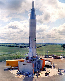
The 550th Strategic Missile Squadron is an inactive United States Air Force unit. It was last assigned to the 310th Strategic Aerospace Wing, stationed at Schilling AFB, Kansas
Fourway is an unincorporated community in Rappahannock County, in the U.S. state of Virginia.

Salar is a municipality in the province of Granada, Spain. As of 2010, it has a population of 2831 inhabitants.
Tidemill is an unincorporated community in Gloucester County, in the U. S. state of Virginia.

Paisaje is an unincorporated community in Conejos County, in the U.S. state of Colorado.
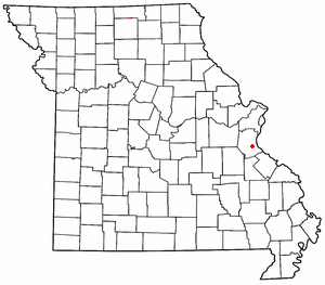
Jarvis is an unincorporated community in Jefferson County, in the U.S. state of Missouri. Jarvis is located approximately 1.5 miles northwest of Mapaville and 2.5 miles southeast of Goldman.
Papin is an unincorporated community in Jefferson County, in the U.S. state of Missouri.
Municipalities and communities of Dorchester County, Maryland, United States | ||
|---|---|---|
| City | 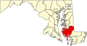 | |
| Towns | ||
| CDP | ||
| Other communities | ||
| Footnotes | ‡This populated place also has portions in an adjacent county or counties | |
Coordinates: 38°16′05″N76°04′04″W / 38.26806°N 76.06778°W
| This article about a location in Dorchester County Maryland is a stub. You can help Wikipedia by expanding it. |