Secretary, Maryland

Last updated

Secretary, Maryland
Flag of Secretary, Maryland.png
Seal of Secretary, Maryland.png
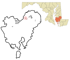
Dorchester County Maryland Incorporated and Unincorporated areas Secretary Highlighted.svg
Location of Secretary, Maryland
Coordinates: 38°36′36″N75°56′56″W / 38.61000°N 75.94889°W / 38.61000; -75.94889
Country Flag of the United States.svg United States
State Flag of Maryland.svg  Maryland
County Flag of Dochester County, Maryland.png Dorchester
Incorporated 1900 [1]
Area
[2]
  Total0.29 sq mi (0.75 km2)
  Land0.29 sq mi (0.75 km2)
  Water0.00 sq mi (0.00 km2)
Elevation
20 ft (6 m)
Population
 (2020)
  Total472
  Density1,621.99/sq mi (625.70/km2)
Time zone UTC-5 (Eastern (EST))
  Summer (DST) UTC-4 (EDT)
ZIP code
21664
Area code 410
FIPS code 24-70900
GNIS feature ID0591244

Secretary is a town in Dorchester County, Maryland, United States. The population was 535 at the 2010 census.

Contents

Lord Baltimore named the town after his secretary. [3]

Geography

Secretary is located at 38°36′36″N75°56′56″W / 38.61000°N 75.94889°W / 38.61000; -75.94889 (38.609886, -75.949006). [4]

According to the United States Census Bureau, the town has a total area of 0.26 square miles (0.67 km2), all land. [5]

Demographics

Historical population
CensusPop.Note
1900 410
1910 409−0.2%
1920 398−2.7%
1930 361−9.3%
1940 344−4.7%
1950 3440.0%
1960 3512.0%
1970 3520.3%
1980 48738.4%
1990 5288.4%
2000 503−4.7%
2010 5356.4%
2020 472−11.8%
U.S. Decennial Census [6]

2010 census

As of the census [7] of 2010, there were 535 people, 213 households, and 157 families living in the town. The population density was 2,057.7 inhabitants per square mile (794.5/km2). There were 234 housing units at an average density of 900.0 per square mile (347.5/km2). The racial makeup of the town was 88.4% White, 6.4% African American, 0.4% Native American, 0.2% Asian, 3.7% from other races, and 0.9% from two or more races. Hispanic or Latino of any race were 7.3% of the population.

There were 213 households, of which 32.4% had children under the age of 18 living with them, 51.6% were married couples living together, 17.4% had a female householder with no husband present, 4.7% had a male householder with no wife present, and 26.3% were non-families. 20.2% of all households were made up of individuals, and 10.8% had someone living alone who was 65 years of age or older. The average household size was 2.51 and the average family size was 2.86.

The median age in the town was 43.6 years. 23% of residents were under the age of 18; 4.4% were between the ages of 18 and 24; 24.8% were from 25 to 44; 30.8% were from 45 to 64; and 17% were 65 years of age or older. The gender makeup of the town was 49.0% male and 51.0% female.

2000 census

As of the census [8] of 2000, there were 503 people, 197 households, and 146 families living in the town. The population density was 1,944.1 inhabitants per square mile (750.6/km2). There were 218 housing units at an average density of 842.6 per square mile (325.3/km2). The racial makeup of the town was 97.22% White, 0.60% African American, 0.20% Native American, 0.80% Asian, 0.99% from other races, and 0.20% from two or more races. Hispanic or Latino of any race were 3.98% of the population.

There were 197 households, out of which 33.5% had children under the age of 18 living with them, 57.4% were married couples living together, 13.7% had a female householder with no husband present, and 25.4% were non-families. 20.8% of all households were made up of individuals, and 7.6% had someone living alone who was 65 years of age or older. The average household size was 2.54 and the average family size was 2.92.

In the town, the population was spread out, with 23.5% under the age of 18, 7.0% from 18 to 24, 31.4% from 25 to 44, 25.6% from 45 to 64, and 12.5% who were 65 years of age or older. The median age was 38 years. For every 100 females, there were 95.7 males. For every 100 females age 18 and over, there were 91.5 males.

The median income for a household in the town was $39,063, and the median income for a family was $40,441. Males had a median income of $26,023 versus $22,292 for females. The per capita income for the town was $15,881. About 10.3% of families and 12.7% of the population were below the poverty line, including 14.1% of those under age 18 and 15.3% of those age 65 or over.
Related Research Articles

<span class="mw-page-title-main">Blades, Delaware</span> Town in Delaware, United States

Blades is a town in Sussex County, Delaware, United States. As of the 2010 census, the town population was 1,241, a 29.8% increase over the previous decade. It is part of the Salisbury, Maryland-Delaware Metropolitan Statistical Area.

<span class="mw-page-title-main">Eagle Lake, Maine</span> Town in the state of Maine, United States

Eagle Lake is a town in Aroostook County, Maine, United States. The population was 772 at the 2020 census. The town was named by a body of troops heading from Bangor to the Aroostook War for the many eagles that they saw around the lake. A total of 49.0% of the population speaks French, reflecting a trend in Northeastern Maine.

<span class="mw-page-title-main">Littleton, Maine</span> Town in the state of Maine, United States

Littleton is a town in Aroostook County, Maine, United States. The population was 997 at the 2020 census.

<span class="mw-page-title-main">Mapleton, Maine</span> Town in the state of Maine, United States

Mapleton is a town in Aroostook County, Maine, United States. The population was 1,886 at the 2020 census.

<span class="mw-page-title-main">Merrill, Maine</span> Town in the state of Maine, United States

Merrill is a town in Aroostook County, Maine, United States. The population was 208 at the 2020 census.

<span class="mw-page-title-main">Wallagrass, Maine</span> Town in the state of Maine, United States

Wallagrass is a town in Aroostook County, Maine, United States. The population was 519 at the 2020 census.

<span class="mw-page-title-main">Chesterville, Maine</span> Town in Maine, United States

Chesterville is a town in Franklin County, Maine, United States. The population was 1,328 at the 2020 census.

<span class="mw-page-title-main">Vienna, Maine</span> Town in the state of Maine, United States

Vienna is a town in Kennebec County, Maine, United States. The population was 578 at the 2020 census.

Stoneham is a town in Oxford County, Maine, United States. The population was 261 at the 2020 census.

Chester is a town in Penobscot County, Maine, United States. The population was 549 at the 2020 census.

<span class="mw-page-title-main">Whitneyville, Maine</span> Town in the state of Maine, United States

Whitneyville is a town in Washington County, Maine, United States. The town was named after Colonel Joseph Whitney, a mill owner. The population was 202 at the 2020 census.

<span class="mw-page-title-main">Midland, Maryland</span> Town in Maryland, United States

Midland is a town in Allegany County, Maryland, United States, along the Georges Creek Valley. It is part of the Cumberland, MD-WV Metropolitan Statistical Area. The population was 446 at the 2010 census. Midland was founded in 1850 as a coal-mining community, though today only some strip mining remains.

<span class="mw-page-title-main">Etna, Pennsylvania</span> Borough in Pennsylvania, United States

Etna is a borough in Allegheny County, Pennsylvania, United States, located across the Allegheny River from Pittsburgh. The population was 3,437 at the 2020 census. It is a suburb of the Pittsburgh metropolitan area.

<span class="mw-page-title-main">Chesapeake, West Virginia</span> Town in West Virginia, United States

Chesapeake is a town in Kanawha County, West Virginia, United States. The population was 1,336 at the 2020 census. The town is situated on the Kanawha River.

<span class="mw-page-title-main">Pratt, West Virginia</span> Town in West Virginia, United States

Pratt is a town in Kanawha County, West Virginia, United States, along the Kanawha River. The population was 482 at the 2020 census.

<span class="mw-page-title-main">Henderson, West Virginia</span> Unincorporated Town in West Virginia, United States

Henderson is an unincorporated community and former town in Mason County, West Virginia, United States, at the confluence of the Ohio and Kanawha Rivers. The population was 231 at the 2020 census. It is part of the Point Pleasant, WV–OH Micropolitan Statistical Area. The town was incorporated in 1893 and named for Samuel Bruce Henderson, who owned the townsite at the time. The town was unincorporated following a public hearing on August 11, 2022.

<span class="mw-page-title-main">New Haven, West Virginia</span> Town in West Virginia, United States

New Haven is a town in Mason County, West Virginia, United States, along the Ohio River. The population was 1,485 at the 2020 census. It is part of the Point Pleasant, WV–OH Micropolitan Statistical Area.

<span class="mw-page-title-main">Bancroft, West Virginia</span> Town in West Virginia, United States

Bancroft is a town in Putnam County, West Virginia, United States, along the Kanawha River. The population was 389 at the 2020 census. It is part of the Huntington–Ashland metropolitan area.

<span class="mw-page-title-main">St. Albans, Maine</span> Town in the state of Maine, United States

St. Albans is a town in Somerset County, Maine, United States. The population was 2,045 at the 2020 census.

<span class="mw-page-title-main">East Millinocket, Maine</span> Town in the state of Maine, United States

East Millinocket is a town in Penobscot County, Maine, United States. The population was 1,572 at the 2020 census.

References

  1. "Secretary". Maryland Manual. Retrieved June 25, 2017.
  2. "2020 U.S. Gazetteer Files". United States Census Bureau. Retrieved April 26, 2022.
  3. Moyer, Armond; Moyer, Winifred (1958). The origins of unusual place-names. Keystone Pub. Associates. p. 117.
  4. "US Gazetteer files: 2010, 2000, and 1990". United States Census Bureau. February 12, 2011. Retrieved April 23, 2011.
  5. "US Gazetteer files 2010". United States Census Bureau. Archived from the original on July 2, 2012. Retrieved January 25, 2013.
  6. "Census of Population and Housing". Census.gov. Retrieved June 4, 2015.
  7. "U.S. Census website". United States Census Bureau . Retrieved January 25, 2013.
  8. "U.S. Census website". United States Census Bureau . Retrieved January 31, 2008.