Kristiansand Region is a statistical metropolitan region in the counties of Vest-Agder and Aust-Agder in southern Norway. It is centered on the city of Kristiansand. The region consist of 6 municipalities in the centre of Southern Norway. Vennesla, Songdalen, and Birkenes are inland municipalities while Kristiansand, Søgne, and Lillesand are coastal municipalities. Kristiansand is the largest municipality in population in the region and Birkeland is the largest in area.

Southern Norway is the geographical region (landsdel) along the Skagerrak coast of southern Norway. The region is an informal description since it does not have any governmental function. It roughly corresponds to the old petty kingdom of Agder as well as the two present-day counties of Vest-Agder and Aust-Agder. The total combined area of Vest-Agder and Aust-Agder counties is 16,493 square kilometres (6,368 sq mi). The name is relatively new, having first been used in Norway around 1900.

Presteheia is a neighborhood in the city of Kristiansand in Vest-Agder county, Norway. It is located in the borough of Lund in the district of Gimlekollen. It is located to the west of Bjørndalssletta, north of Oddemarka, and east of Gimlemoen. The neighborhood developed after the year 2000 has many "rekkehus" and terrace blocks. The residents of the area are both young families and elderly people. The view from Presteheia is magnificent overlooking the borough of Lund, the University of Agder, and the downtown Kvadraturen area. You can see both Oksoy and the island of Odderøya from the top of Presteheia.

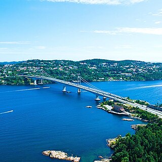
Oddernes is a borough in the municipality of Kristiansand in Vest-Agder county, Norway. The borough covers eastern Kristiansand on the east side of the Topdalsfjorden and the Varodd Bridge. The borough includes the former municipalities of Randesund and Tveit. There was a municipality of Oddernes from 1838 until 1965, but its boundaries were very different from those of the present-day borough.

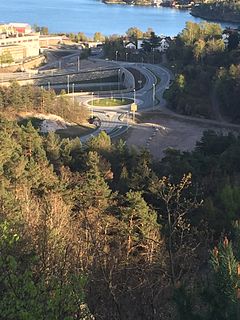
Oddemarka is a neighborhood in the city of Kristiansand in Vest-Agder county, Norway. It is located in the borough of Lund. The European route E18 highway passes by the neighborhood on the north side. The neighborhood of Presteheia lies to the north of Oddemarka, Kjøita lies to the west, and Marvika lies to the south. Oddemarka school is located in the neighborhood.

Norwegian National Road 41 is a Norwegian national road that runs through Telemark, Aust-Agder, and Vest-Agder counties in Norway. The road runs between the village of Brunkeberg in Kviteseid municipality in Telemark county in the north and Timenes in Hånes in the city of Kristiansand in Vest-Agder county in the south. The 172.9-kilometre (107.4 mi) long road connects to the European route E134 highway in the north and to the European route E18 highway in the south. The road runs for 12.5 kilometres (7.8 mi) in Vest-Agder county, 89 kilometres (55 mi) in Aust-Agder county, and 71.4 kilometres (44.4 mi) in Telemark county. The southern half of the road runs along the river Tovdalselva and the lake Herefossfjorden, and it is located in a fault zone called the Kristiansand-Porsgrunn grabenen.

Norwegian National Road 9 is often called the Setesdal Road and it is the main thoroughfare through the Setesdalen valley. It runs from the city of Kristiansand in the southern coast of Norway, through the Torridal and Setesdal valleys in Vest-Agder and Aust-Agder counties to Haukeligrend in Telemark county in the north where it meets the European route E134 highway. The highway goes through the villages of Mosby, Homstean, Skarpengland, Hægeland, Hornesund, Hornnes, Evje, Byglandsfjord, Bygland, Ose, Rysstad, Valle, Flatland, Rygnestad, Bykle, Hovden, Bjåen, and Haukeli.

Vollevannet is a freshwater is a lake in the municipality of Kristiansand in Vest-Agder county, Norway. The 0.15-square-kilometre (37-acre) lies in the district of Gimlekollen in the borough of Lund, and the surrounding residential area is also called Vollevannet. The lake lies along the European route E18 highway at the exit for the Vest-Agder Museum Kristiansand and Ålefjær. Historically, the lake was used as a reservoir for the city's drinking water. The lake is held back by two dams, and there is a small, sandy beach at the northeast end of the lake. The lake has perch in it.

Vågsbygd is a borough and district in the city of Kristiansand in Vest-Agder county, Norway. It is the largest borough and district in Kristiansand. Until 1965, Vågsbygd was a part of Oddernes municipality. The borough includes the districts of Flekkerøy, Voiebyen, Vågsbygd/Augland, and Slettheia. The Kristiansand Cannon Museum on Kroodden is an authentic fortress from World War II.

Grim is a borough in the city of Kristiansand in Vest-Agder county, Norway. The borough has a population of about 16,000 people and is the second least populated borough in Kristiansand. Grim is located in the northwestern part of the municipality, north of Vågsbygd borough, northwest of Kvadraturen borough, and west of Lund borough. Grim also borders Songdalen and Vennesla municipalities to the west and north, respectively.

Lund is a borough and district in the city of Kristiansand in Vest-Agder county, Norway. It is the second largest borough in the city after Vågsbygd. In 2015, the population was about 30,000. Lund is divided into 4 districts: Lund (centrum), Gimlekollen, Justvik, and Ålefjær.

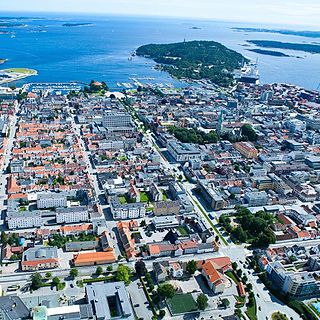
Kvadraturen is the city center of Kristiansand in Vest-Agder county, Norway, with a population of 6,750 (2015). The borough is made up of the centre together with the harbour to the south and the more rural district of "Eg" to the north. Kvadraturen is the administrative centre of the municipality of Kristiansand as well as the administrative centre of Vest-Agder county, but is far smaller in area than the other boroughs in the municipality, such as the borough of Grim to the north and west, and the borough of Lund to the east.

Hannevika or Hannevig / Hannevik is a neighbourhood in the city of Kristiansand in Vest-Agder county, Norway. It is located in the borough of Grim and in the district of Tinnheia. The neighborhood is located along the European route E39 highway and the start of Norwegian County Road 456. Hannevika is a large industrial area. Glencore and Hennig-Olsen Iskremfabrikk are the two largest industries located there. Hannevika is located southeast of Eigevannskollen, northeast of Kartheia, and south of Kolsberg.

Rona is a neighborhood in the city of Kristiansand in Vest-Agder county, Norway. It is a part of the Oddernes borough and the district of Søm. The neighbourhood is next to European route E18, and spans the Indre Rona strait between Drangsvatna lake and the Topdalsfjorden. The neighborhood of Strømsdalen lies to the north and Strømme lies to the south. The closest school is Strømme Elementary school. All local bus lines goes through Rona.

Strømsdalen is a neighbourhood in the city of Kristiansand in Vest-Agder county, Norway. It is a part of the Oddernes borough and the district of Søm. The neighborhood is next to the European route E18 highway, just southwest of Vigvoll and north of Stromme. The closest school is Strømme Elementary school. All local bus lines bound to Oddernes goes through Strømsdalen. There is a bank and a pizza restaurant at Strømsdalen, other than that Rona is the closest to a centrum.

Vigvoll is a neighborhood in the city of Kristiansand in Vest-Agder county, Norway. It is a part of the Oddernes borough and the district of Hånes. The neighborhood lies north of the European route E18 highway, west of the Norwegian National Road 41, and east of the Topdalsfjorden. Vigvoll skole is the only junior high at Hånes. Bus line M2 goes though Vigvoll continuing to Hånes, Voiebyen, or Sørlandsparken. It includes a small shopping area known locally as Hånni.

Kartheia is a neighbourhood in the city of Kristiansand in Vest-Agder county, Norway. It is located in the northern part of the borough of Vågsbygd and in the district of Slettheia. The neighborhood lies southwest of the junction of the European route E39 highway and the County Road 456. The district of Hellemyr lies to the north. Kartheia contains residential areas as well as a large industrial area. Gislemyr lies to the south, Trane lies to the west, and Hannevika lies to the east.

Gimle is a neighbourhood in the city of Kristiansand in Vest-Agder county, Norway. It's located in the borough of Lund. It is located near the neighborhoods of Oddemarka and Presteheia. The neighborhood of Kjøita lies to the southwest and the neighborhood of Marvika lies to the southeast.

Hannevikåsen is a neighbourhood in the city of Kristiansand in Vest-Agder county, Norway. It is located in the borough of Grim and in the district of Tinnheia. It lies up the hill from Hannevika and Kolsdalen. The European route E39 highway runs underneath the south end of the neighborhood.

Bellevue is a neighbourhood in the city of Kristiansand in Vest-Agder county, Norway. It is located in the borough of Grim and in the district of Grim. Bellevue is southeast of Idda. The European route E18 highway runs along the east side of the neighborhood and the Norwegian National Road 9 runs just north of the neighborhood. National Archival Services of Norway for Southern Norway is located in Bellevue.


