Issaquena County is a county located in the U.S. state of Mississippi. As of the 2010 census, the population was 1,406, making it the least populous county in the United States east of the Mississippi River. Its county seat is Mayersville. With a per-capita income of $18,598, Issaquena County is the poorest county in the United States.

Bolivar County is a county located on the western border of the U.S. state of Mississippi. As of the 2010 census, the population was 34,145. Its county seats are Rosedale and Cleveland. The county is named in honor of Simón Bolívar, early 19th-century leader of the liberation of several South American colonies from Spain.
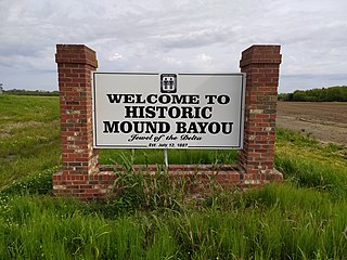
Mound Bayou is a city in Bolivar County, Mississippi, United States. The population was 1,533 at the 2010 census, down from 2,102 in 2000. It is notable for having been founded as an independent black community in 1887 by former slaves led by Isaiah Montgomery.

Glendora is a village in Tallahatchie County, Mississippi. The population was 285 at the 2000 census.

Tarkiln Bayou Preserve State Park is a 4,290-acre (17.4 km2) preserve, a unit of Florida State Park located 10 miles (16 km) southwest of Pensacola, in northwestern Florida. It is home to four species of endangered pitcher plants, as well as other rare and endangered plant species. The rare, carnivorous white–top pitcher plant is unique to the Gulf Coast and found only between the Apalachicola and Mississippi rivers. Almost 100 other rare plants and animals depend on the wet prairie habitat, including the alligator snapping turtle, sweet pitcher plant, and Chapman's butterwort. Tarkiln Bayou Preserve State Park is located in Escambia County about 1.5 miles (2.4 km) south of the intersection of U.S. Hwy. 98 and State Road 293.

Gulf Islands National Seashore offers recreation opportunities and preserves natural and historic resources along the Gulf of Mexico barrier islands of Florida and Mississippi. The protected regions include mainland areas and parts of seven islands. Some islands along the Alabama coast were originally considered for inclusion, but none are part of the National Seashore.

The Atchafalaya Basin, or Atchafalaya Swamp, is the largest wetland and swamp in the United States. Located in south central Louisiana, it is a combination of wetlands and river delta area where the Atchafalaya River and the Gulf of Mexico converge. The river stretches from near Simmesport in the north through parts of eight parishes to the Morgan City southern area.
The Regional Council of Negro Leadership (RCNL) was a society in Mississippi founded by T. R. M. Howard in 1951 to promote a program of civil rights, self-help, and business ownership. It pledged "to guide our people in their civic responsibilities regarding education, registration and voting, law enforcement, tax paying, the preservation of property, the value of saving and in all things which will make us stable, qualified conscientious citizens." Instead of starting from the "grass roots," however, the strategy was to "reach the masses through their chosen leaders" by harnessing the talents of blacks with a proven record in business, the professions, education, and the church.

Philipp is an unincorporated community in southern Tallahatchie County, Mississippi, United States, along Mississippi Highway 8. Philipp is 6 miles (9.7 km) east of Minter City and 14 miles (23 km) west of Holcomb. Although Philipp is an unincorporated community, it has a post office with a ZIP code of 38950.

The geography of Arkansas varies widely. The state is covered by mountains, river valleys, forests, lakes, and bayous in addition to the cities of Arkansas. Hot Springs National Park features bubbling springs of hot water, formerly sought across the country for their healing properties. Crowley's Ridge is a geological anomaly rising above the surrounding lowlands of the Mississippi embayment.
Bayou Cocodrie National Wildlife Refuge was established in 1992 to preserve waterfowl habitat and hardwood forest of the lower Mississippi river. The 13,200-acre (53 km2) refuge is located in Concordia Parish, Louisiana, 10 miles (16 km) southwest of Vidalia, Louisiana. It is named for the state-designated scenic river of Bayou Cocodrie.

The Atchafalaya National Wildlife Refuge is located about 30 miles (48 km) west of Baton Rouge, Louisiana, and one mile (1.6 km) east of Krotz Springs, Louisiana, lies just east of the Atchafalaya River. In 1988 under the administration of Governor Foster the "Atchafalaya Basin Master Plan" was implemented that combined the 11,780-acre (4,770 ha) Sherburne Wildlife Management Area (WMA), the 15,220-acre (6,160 ha) Atchafalaya National Wildlife Refuge, and the 17,000-acre (6,900 ha) U.S. Army Corps of Engineers' Bayou Des Ourses into the Sherburne Complex Wildlife Management Area.

Frenchmans Bayou is an unincorporated community in Mississippi County, Arkansas, United States. Frenchmans Bayou is located at the intersection of U.S. Route 61 and Arkansas Highway 308, 3.5 miles (5.6 km) southwest of Joiner. Frenchmans Bayou has a post office with ZIP code 72338.
Plum Bayou culture is a Pre-Columbian Native American culture that lived in what is now east-central Arkansas from 650–1050 CE, a time known as the Late Woodland Period. Archaeologists defined the culture based on the Toltec Mounds site and named it for a local waterway.
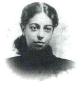
Mary Cordelia Montgomery Booze (1878–1955), a daughter of former slaves, was the first African-American woman to sit on the Republican National Committee. From 1924 until her death, she was the national committeewoman for her native state of Mississippi.
The Mississippi Enterprise was one of two African-American newspapers in Jackson, Mississippi. Arrington High worked at the paper. Publication years include 1939–1980. The paper covered lynchings and murders of African Americans. It advocated for African Americans to support African-American businesses in Mound Bayou, Mississippi, a historically African-American community founded by freed slaves. The Library of Congress has an archive of the paper.