
The Black Rock Desert is a semi-arid region of lava beds and playa, or alkali flats, situated in the Black Rock Desert–High Rock Canyon Emigrant Trails National Conservation Area, a silt playa 100 miles (160 km) north of Reno, Nevada that encompasses more than 300,000 acres (120,000 ha) of land and contains more than 120 miles (200 km) of historic trails. It is in the northern Nevada section of the Great Basin with a lakebed that is a dry remnant of Pleistocene Lake Lahontan.

The Red Cedar River is a tributary of the Grand River in central Michigan in the United States. The river is approximately 51.1 miles (82.2 km) long and drains a watershed of approximately 461 square miles (1,190 km2) in the Lansing–East Lansing metropolitan area and suburban and rural areas to the east.

The Chippewa River is a stream in Michigan, United States, that runs 91.8 miles (147.7 km) through the central Lower Peninsula. The Chippewa is a tributary of the Tittabawassee River and is thus part of the Saginaw River drainage basin. The river is named after the Chippewa people.
Carp River is a 40.2-mile-long (64.7 km) river in Chippewa and Mackinac counties in the U.S. state of Michigan. 21.7 miles (34.9 km) of the river were added to the National Wild and Scenic Rivers System in 1992.
The Black River is a 41.1-mile-long (66.1 km) river on the Upper Peninsula of the U.S. state of Michigan, flowing mostly in Gogebic County into Lake Superior at 46°40′03″N90°02′57″W. Its source at 46°18′54″N90°01′15″W is a boreal wetland on the border with Iron County, Wisconsin. The northern section of the river, 14 miles (23 km) within the boundaries of the Ottawa National Forest, was designated a National Wild and Scenic River in 1992.

Black River is a 78.8-mile-long (126.8 km) river in the U.S. state of Michigan, flowing mostly northward through four Northern Michigan counties: Otsego, Montmorency, Presque Isle, and Cheboygan. The Black River flows into the Cheboygan River at 45°36′13″N84°27′47″W, just south of the city of Cheboygan, and then into Lake Huron. The main branch of the Black River rises in Charlton Township in east-central Otsego County near the boundary with Montmorency County. The East Branch of the Black River rises less than a mile to the east in Vienna Township in Montmorency County. The other major tributaries, Canada Creek, Tomahawk Creek and the Rainy River all rise in northern Montmorency County.
Black River is a 4.2-mile-long (6.8 km) river in the southwest part of the U.S. state of Michigan that empties into Lake Michigan in South Haven at 42°24′08″N86°17′04″W, where it discharges past the South Pier Lighthouse. The river takes its name from the dark brown color of its water, which is caused by suspended sediments and organic materials picked up along its course. The river supports a variety of wildlife including trout, snapping turtles, leeches, and many other varieties of flora and fauna. The Black River watershed encompasses 287 square miles (740 km2) across two counties and 13 townships.

Black River is an 81.0-mile-long (130.4 km) river in the U.S. state of Michigan, flowing into the St. Clair River in the city of Port Huron. The Black River Canal in northern Port Huron extends east into Lake Huron near Krafft Road.
Cedar River is a 67.1-mile-long (108.0 km) river in the U.S. state of Michigan. It rises in the northern part of Menominee County at 45°53′18″N87°35′15″W and flows mostly south and east to empty into Green Bay of Lake Michigan at 45°24′35″N87°21′05″W in the community of Cedar River.

Mahoning Creek is a tributary of the Allegheny River in Pennsylvania in the United States.

Wappinger Creek is a 41.7-mile-long (67.1 km) creek which runs from Thompson Pond to the Hudson River at New Hamburg in Dutchess County, New York, United States. It is the longest creek in Dutchess County, with the largest watershed in the county.
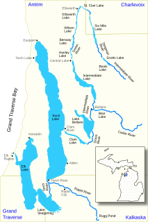
The Elk River Chain of Lakes Watershed is a 75-mile-long (121 km) waterway consisting of 14 lakes and connecting rivers in the northwestern section of the Lower Peninsula of the U.S. state of Michigan, which empty into Lake Michigan.
Sturgeon River is a 63.6-mile-long (102.4 km) river in the U.S. state of Michigan, flowing mostly southward through Alger County and Delta County counties on the Upper Peninsula.
Little Cedar River is a 56.7-mile-long (91.2 km) river in Menominee County in the U.S. state of Michigan.
Carp River is a 10.3-mile-long (16.6 km) river in Gogebic and Ontonagon counties in the U.S. state of Michigan. The Carp River is formed by the outflow of the Lake of the Clouds at 46°48′04″N89°45′38″W in the Porcupine Mountains of the Upper Peninsula.
Carp River is a 21.9-mile-long (35.2 km) river in Marquette County in the U.S. state of Michigan. The Carp River is formed by the outflow of Deer Lake in Ishpeming Township north of Ishpeming at 46°31′58″N87°40′01″W in the Upper Peninsula.

The Pine River is a 103-mile-long (166 km) river in the Lower Peninsula of the U.S. state of Michigan. The Pine River is a tributary of the Chippewa River and is thus part of the Saginaw River drainage basin.
North Branch Little Black Creek drains North Branch Lake and flows west passing to the south of Forty Mountain before flowing into Little Black Creek in Wheelertown, New York.

North Branch Lake is located east of North Wilmurt, New York in the Town of Ohio. North Branch Lake is the source of the North Branch Little Black Creek.

