The Alabaha River is a 20.6-mile-long (33.2 km) tributary of the Satilla River in the U.S. state of Georgia. It forms in northwestern Pierce County at the junction of Hurricane Creek and Little Hurricane Creek and flows southeast, past the county seat of Blackshear, and joins the Satilla River at the Pierce County/Brantley County boundary.
Alligator Creek is a 48.6-mile-long (78.2 km) tributary of the Little Ocmulgee River in the U.S. state of Georgia.
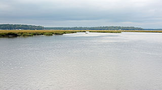
The Bear River is a 13-mile-long (21 km) tidal river in the U.S. state of Georgia. It forms the channel that separates Ossabaw Island from the Georgia mainland, connecting with the Ogeechee River at its north end and the Medway River at its south.

Big Satilla Creek is a 55.8-mile-long (89.8 km) tributary of the Little Satilla River in the U.S. state of Georgia. It is part of the Satilla River watershed of southeastern Georgia.
The Halfmoon River is a 4.6-mile-long (7.4 km) tidal river in the U.S. state of Georgia. It flows through saltmarshes connected to Wilmington Island in Chatham County, ending at Wassaw Sound, an arm of the Atlantic Ocean.
The Laurel View River is a 4.6-mile-long (7.4 km) tidal river in the U.S. state of Georgia. It is fed by the Jerico River, which splits into the Laurel View and Belfast rivers, and ends where the Belfast River rejoins it, forming the Medway River, which continues to the Atlantic Ocean. For its entire length, the Laurel View River forms the boundary between Bryan and Liberty counties.
The Little Ocmulgee River is a 28.3-mile-long (45.5 km) tributary of the Ocmulgee River in the U.S. state of Georgia.

The Little Ogeechee River in Hancock County is one of two rivers with that name in the U.S. state of Georgia. It rises in Hancock County northeast of Sparta and flows southeast into Washington County, passing through Hamburgh State Park and entering the Ogeechee River 3 miles (5 km) southwest of Mitchell. The river is 21.3 miles (34.3 km) long.
The Little River is a 72-mile-long (116 km) tributary of the Savannah River in the U.S. state of Georgia. It is formed by the juncture of its North and South forks 5 miles (8 km) north of Crawfordville, and it flows generally east to Clark Hill Lake, where it joins the Savannah River 2 miles (3 km) north of the dam.

The Little Satilla Creek is a 39.3-mile-long (63.2 km) tributary of the Little Satilla River in the U.S. state of Georgia. It is part of the Satilla River watershed in southeastern Georgia.
The Little Satilla River is a 22.6-mile-long (36.4 km) tidal river that forms the boundary between Glynn and Camden counties in the U.S. state of Georgia. It is a separate river from the Little Satilla River, 20 miles (32 km) to the northwest, that is a freshwater tributary of the Satilla River.
The New River is a 34.4-mile-long (55.4 km) tributary of the Withlacoochee River in the U.S. state of Georgia. Via the Withlacoochee and Suwannee rivers, its waters flow to the Gulf of Mexico.
The Odingsell River is a 5.7-mile-long (9.2 km) tidal river in the U.S. state of Georgia. It flows into Ossabaw Sound just north of the mouth of the Ogeechee River. It passes through salt marshes lying between Skidaway Island to the west, Wassaw Island to the north and east, and Little Wassaw Island to the south.
Rocky Comfort Creek is a 62.4-mile-long (100.4 km) tributary of the Ogeechee River in the U.S. state of Georgia. Rising in Warren County 9 miles (14 km) northwest of Warrenton, it flows southeast, entering Glascock County and passing the town of Gibson, then continuing south into Jefferson County, where it reaches the Ogeechee River at Louisville.
The Sapelo River is a 23-mile-long (37 km) primarily tidal river in McIntosh County in the U.S. state of Georgia. It forms between Interstate 95 and U.S. Route 17 near the community of Eulonia and winds generally east through salt marshes into Sapelo Sound, an arm of the Atlantic Ocean that separates St. Catherines Island to the north from Sapelo Island to the south.
The South Newport River is a 42.6-mile-long (68.6 km) river on the Atlantic coastal plain in the U.S. state of Georgia. It rises in Long County 3 miles (5 km) south of Walthourville and flows east-southeast, becoming the boundary between Liberty and McIntosh counties. It flows into Sapelo Sound, an arm of the Atlantic Ocean, south of St. Catherines Island.
Suwannoochee Creek is a 49.0-mile-long (78.9 km) tributary of the Suwannee River in the U.S. state of Georgia. It rises in western Clinch County, Georgia, about 11 miles (18 km) west of Homerville, and flows southeast to join the Suwannee near Fargo. For the lower half of its course it forms the boundary between Clinch and Echols counties.

The Turtle River is a 17.6-mile-long (28.3 km) tidal river in the vicinity of Brunswick, Georgia. It is the main tributary of the Brunswick River.
The Vernon River is a 12.4-mile-long (20.0 km) primarily tidal river in the U.S. state of Georgia. Located in Chatham County, it rises south of Hunter Army Airfield in Savannah and flows south into tidal marshes, where it joins the Little Ogeechee River southwest of Skidaway Island.
The Williamson Swamp Creek is a 52.4-mile-long (84.3 km) tributary of the Ogeechee River in the U.S. state of Georgia. Rising in northwestern Washington County 12 miles (19 km) north of Sandersville, it flows southeast past Davisboro and enters Jefferson County, ending at the Ogeechee River 5 miles (8 km) southeast of Wadley.


