
Fort Bridger was originally a 19th-century fur trading outpost established in 1842, on Blacks Fork of the Green River, in what is now Uinta County, Wyoming, United States. It became a vital resupply point for wagon trains on the Oregon Trail, California Trail, and Mormon Trail. The Army established a military post here in 1858 during the Utah War, until it was finally closed in 1890. A small town, Fort Bridger, Wyoming, remains near the fort and takes its name from it.

Bingham Canyon was a city formerly located in southwestern Salt Lake County, Utah, United States, in a narrow canyon on the eastern face of the Oquirrh Mountains. The Bingham Canyon area boomed during the first years of the twentieth century, as rich copper deposits in the canyon began to be developed, and at its peak the city had approximately 15,000 residents. The success of the local mines eventually proved to be the town's undoing, however: by the mid-twentieth century, the huge open-pit Bingham Canyon Mine began encroaching on the land of the community, causing residents to relocate. By the 1970s, almost the entirety of the town had been devoured by the mine, and the few remaining residents voted to disincorporate and abandon the community. No trace of Bingham Canyon remains today.

Tucker is a ghost town located near the east end of the Spanish Fork River in Utah County, Utah, United States 7 miles (11 km) below Soldier Summit on U.S. Route 6. It was once an important loading point and construction camp on the Denver and Rio Grande Western Railroad (D&RGW). After the town was abandoned, the state of Utah used the town site for a rest area. In 2009, the site was buried as part of a project to re-align a portion of US-6's western approach to Soldier Summit. To honor the town, the state of Utah built a replacement rest area about 2 miles (3.2 km) downstream from Tucker, called the Tie Fork Rest Area.

Colton is a ghost town located near the southeastern edge of Utah County, Utah, United States, approximately 6 miles (9.7 km) south of Soldier Summit. Formerly a busy railroad junction on the Denver and Rio Grande Western Railroad, Colton is a landmark on U.S. Route 6 between the cities of Spanish Fork and Price.
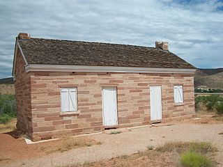
Linwood was an unincorporated village in north-central Daggett County, Utah, United States, near the Wyoming state line.
Mohrland is a ghost town located in Emery County, Utah, United States. Lying in Cedar Creek Canyon near the Carbon County line, Mohrland was Emery County's largest coal mining town, with a history more typical of Carbon County's coal camps than of most Emery County communities.

Mill Fork is a ghost town located approximately 12 miles (19 km) east of Thistle in Spanish Fork Canyon in Utah County, Utah, United States. Named for its sawmills, Mill Fork was important in the development of the railroad through the canyon. The arched entrance to the small, well-tended Mill Fork Cemetery is a landmark on U.S. Route 6 between the cities of Spanish Fork and Price.

Paria or Pahreah, is a ghost town on the Paria River in Grand Staircase–Escalante National Monument in central Kane County, Utah, United States. It was inhabited from 1870 to 1929, and later used as a filming location.

Forest City is a ghost town in Utah County, Utah, United States. It is located in the valley of Dutchman Flat in the upper part of American Fork Canyon, in the Uinta National Forest. A silver mining town just over the mountain from Alta, Forest City was inhabited about 1871–1880. The town grew up around the smelter that was built to process ore from the canyon's mines. The American Fork Railroad, which was intended to serve Forest City and the smelter, stopped short of its destination due to engineering difficulties. Transportation costs rose too high for the mines to continue operating profitably. As the smelter, mines, and railroad closed down, Forest City was abandoned.
Castleton is a ghost town in the Castle Valley in southeastern Grand County, Utah, United States.

Newhouse is a ghost town located on the eastern edge of the Wah Wah Valley in Beaver County, Utah, United States. A silver mining town based on the Cactus Mine on the western slopes of the San Francisco Mountains, Newhouse was smaller and quieter than Frisco, 5 miles (8.0 km) to the southeast.

Duncan's Retreat is a ghost town located just off Utah State Route 9 in the eastern part of Washington County, in southwestern Utah, United States. Lying some 3 miles (4.8 km) east of Virgin and just southwest of Zion National Park, Duncan's Retreat was inhabited about 1861–1895.

Silver City is a ghost town located at the mouth of Dragon Canyon on the west flank of the East Tintic Mountains in northeast Juab County in central Utah, United States. It was a silver mining town approximately 90 miles (140 km) south-southwest of Salt Lake City. This area was considered part of the Tintic Mining District and also produced bismuth, copper, gold, and lead. Settlement began with the first mining strikes here in 1869. Silver City was inhabited until 1930, after the mines played out. Jesse Knight, known as the "Mormon Wizard" for his ability to find ore easily, decided to build a smelter in Silver City because it had the flattest ground in all of the Tintic Mining District. Silver City had several mines in 1890, but the mines hit water and were abandoned. Now there is little left other than a few holes where mines were, and a number of tailings piles. The Silver City Cemetery, however, survives and is listed on the National Register of Historic Places.
Coal City is a ghost town in Carbon County, Utah, United States. Established in 1885, Coal City was initially a farming community until coal was discovered in the area. Small-scale mining began to take place, and because the mining operations were a mile or two away from the mines at National and Consumers, it was assumed that the citizens of the town would lack workplace stress. Coal production began to decline in 1935, and the town was essentially abandoned with just two residences occupied by the late 1960s.
Winter Quarters is a ghost town in Carbon County, Utah, United States. Coal was discovered in the area in 1875, and later that year, the Pleasant Valley Coal Company began coal mining operations. A group of coal miners were delayed during an early winter storm in 1877, which led to the town's name of Winter Quarters. On May 1, 1900, an explosion in the Winter Quarters Number Four mine killed 200 miners. Despite the mine explosion, the coal mining operations remained active until 1922, when the opening of a new mine in Castle Gate caused many people to relocate there. By 1930, Winter Quarters was abandoned.
Harrisburg is a ghost town in Washington County, Utah, United States. Established as Harrisville in 1859, the town was flooded by the Virgin River in 1862, causing the residents to move farther up Quail Creek. Soon after, the town's name was changed to Harrisburg. By 1868, 200 people lived in Harrisburg; however, over the course of the next few years, floods, Native American raids, and a grasshopper plague caused people to relocate to the nearby towns of Leeds and Silver Reef. By 1895, Harrisburg was abandoned. Presently, the site of Harrisburg is occupied by a real estate project called Harrisburg Estates, but many remnants from its old days are still visible throughout town including the historic cemetery and several sandstone houses. The neighborhood now lies within the legal boundaries of Hurricane.
Cedar Creek is a ghost town in Box Elder County, Utah, United States. Founded in the 1860s, Cedar Creek was a farming town. Businesses included a school, an inn, and a store. The interstate highway system built through Cedar Creek and the nearby communities of Snowville and Park Valley. Cedar Creek was abandoned when weather conditions made farming difficult.

Sulphurdale is a ghost town in Beaver County, Utah, United States. Sulphurdale was established in 1870, but mining did not begin in large scale until 1883. Homes, a school, a store and company offices were built in town. Despite the heavy mining activity, high quality sulfur was difficult to find. Production slowed in the 1940s and 1950s, and in 1966, the mine and mill shut down. By the end of the 1970s, Sulphurdale was abandoned.
Victor is a ghost town in Castle Valley in northern Emery County, Utah, United States.
Desert Lake is a ghost town in Castle Valley in northern Emery County, Utah, United States. It was inhabited from 1885 to about 1910.


