Hoytsville, Utah | |
|---|---|
 Location in Summit County and the state of Utah | |
| Coordinates: 40°52′27″N111°22′42″W / 40.87417°N 111.37833°W | |
| Country | United States |
| State | Utah |
| County | Summit |
| Settled | 1859 |
| Founded by | Thomas Bradberry |
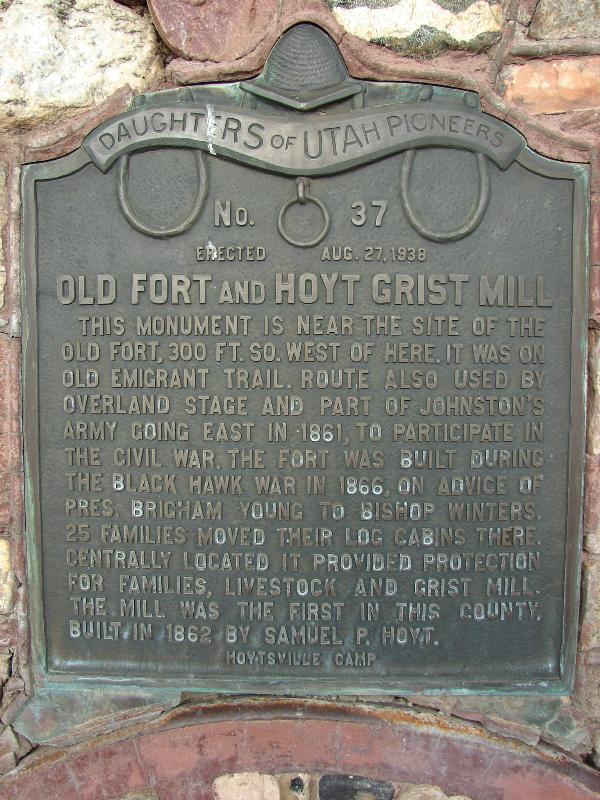
| Named after | Samuel P. Hoyt |
| Elevation | 5,706 ft (1,739 m) |
| Population (2020) | |
• Total | 702 |
| Time zone | UTC-7 (Mountain (MST)) |
| • Summer (DST) | UTC-6 (MDT) |
| ZIP code | 84017 |
| Area code | 435 |
| GNIS feature ID | 2584768 [1] |
Hoytsville is a census-designated place in western Summit County, Utah, United States. Hoytsville is named for early settler Samuel P. Hoyt. It is bordered by Coalville to the north, and by Wanship on the south. The population was 702 at the 2020 census. [2] Interstate 80 passes through the area, as well as the Weber River. Hoytsville is home to a large chapel of the Church of Jesus Christ of Latter-day Saints, a cemetery, and a handful of businesses and farms. Farmers primarily focus on dairy farming, beef ranching, and raising sheep for wool. In the past, mink were also raised although that industry has declined in recent years.
Contents
Hoytsville is also the site of the Hoyt Mansion, considered by the Summit County Historical Society as "one of the most elegant 19th Century homes still standing in Utah today." [3]
