Block Lane

Last updated

Block Lane (Black Ridings)
Greater Manchester UK location map 2.svg
Red pog.svg
Block Lane (Black Ridings)
Location within Greater Manchester
OS grid reference SD 90891 04195
Metropolitan borough
Metropolitan county
Region
Country England
Sovereign state United Kingdom
Post town OLDHAM
Postcode district OL9
Dialling code 0161
Police Greater Manchester
Fire Greater Manchester
Ambulance North West
UK Parliament
List of places
UK
England
Greater Manchester
53°32′04″N2°08′20″W / 53.534327°N 2.1389014°W / 53.534327; -2.1389014

Block Lane is a locality in the town of Chadderton in the Metropolitan Borough of Oldham, Greater Manchester. [1] It is located on Chadderton's eastern border with Oldham, contiguous with the Freehold area of that town, and with Cowhill and Butler Green.

Contents

History

A hamlet at Block Lane, known as Black Ridings, lay on the ancient road of Block Lane as it followed the Oldham boundary southwards towards Butler Green. [2] The hamlet lay at the northern end of Block Lane between the present-day Christ Church and Freehold tram stop. A notable large residence, known simply as 'Block Lane' was described by the local historian James Butterworth as the abode of a Rev. Gee from 1747 onwards. Both the Black Ridings hamlet and the adjacent Block Lane house are shown on the early Ordnance Survey maps of the area. [3] [4]

By the mid 19th century the area had become a centre of industrial activity with four coal pits and two sandstone quarries in close proximity. [5] The expansion of Werneth in the Freehold area from the 1860s onwards saw housing developments reach the administrative edge of the town of Oldham at Block Lane, effectively absorbing the Black Ridings area into that district. Suburban housing now covers the area occupied by the early 18th century cottages which had been demolished by the 1960s.

The Hare And Hounds public house opened in 1855. [5] The pub closed in late 2014 and has now been converted into a private residence.

Blackridings Mill was a cotton waste mill on Block Lane dating to 1861. It was demolished in 1975. It occupied the site of the former Blackridings Colliery. The site was redeveloped in 1982 for Freehold Community School. [6] The mill and former colliery lay on the east side of Block Lane in Oldham, although some early 19th century records speak of the colliery lying within Chadderton. [7]

The United Mill was a cotton mill on Block Lane. Built in 1874, it ceased production in 1959 and was demolished in 1962. A small ancillary building to the mill remains in use as a mosque. [8]

1870 saw the opening of Christ Church, a grade II listed building. [9] [10]

By the 1890s, Block Lane had a bowling green and a football ground at the back of the old Black Ridings hamlet. At one time this was known as 'The Track', a venue for foot races, wrestling, football and rugby. In the late 19th century the ground was used by Werneth Rugby Club, who in 1890 were suspended from league rugby for 'professionalism'. The club disbanded in 1905. [2]

Christ Church (Church Of England)

Christ Church, Chadderton Christ Church, Chadderton.jpg
Christ Church, Chadderton

St John's Church, Werneth (closed in 1982) was the parish church for the Block Lane area from 1845 until 1870 when the new Christ Church was built by a group of laypeople who were unhappy with the increasing ritualism at St John's. They appealed for funds in February 1870 to build a new church on the lower side of the Freehold adjoining Suffolk St at its junction with Oxford St and Block Lane' a church which they planned to 'secure a permanent Evangelical ministry, and to meet the spiritual needs of a rapidly-growing population.' The funds were so quickly forthcoming that the foundation stone was laid in May and the new church was completed and opened by December of that same year, and the first vicar, the Rev'd Thomas Chapman. took his inaugural service on Christmas Day 1870. [11]

Christ Church in time planted a new church on Denton Lane, St Saviour's, which still exists in the 21st century; it also planted Emmanuel Church just off Drury Lane which has now closed and been demolished, the congregation now meeting at its daughter church, St George's building on Broadway; and it began a work at St Gabriel's, Middleton Junction which became a parish in its own right and is still a going concern. In addition it planted mission churches at Butler Green and at Cowhill which ceased to exist in the 20th century. [11]

Christ Church itself still meets in its original building on Block Lane well into the 21st century, but with the addition of a church centre alongside the church on the site of its former day school, and it has a voluntary aided primary school (also called Christ Church) just off Denton Lane on Crawley Way as well as its sister church of St Saviour's and a work on Crossley Estate known as Crossley Christian Centre, now closed. Christ Church is numerically one of the largest parishes in the Oldham West deanery of Manchester diocese with a population of about 15,000 in 2021.

Christ Church is a grade II listed building. The church, in Gothic Revival style, is in stone and has a roof partly of slate and partly of copper with coped gables. It consists of a nave with a clerestory, north and south aisles, a chancel, and a southeast tower. The tower has four stages, angle buttresses, an embattled parapet, and there is a square stair turret with a pyramidal top. [12]

Transport

Freehold Metrolink Station Freehold Metrolink station (4).JPG
Freehold Metrolink Station

First Greater Manchester operate bus service 81 to Manchester City Centre via Moston and Harpurhey and to Oldham with some evening and weekend services provided by Stagecoach Manchester extending to Derker.

Stotts Tours (Oldham) operates bus service 159 to Oldham via Chadderton town centre and to Middleton via Hollinwood, Woodhouses, Failsworth and New Moston. [13] [14] [15]

Freehold tram stop at the northern end of Block Lane provides direct tram links to Manchester and beyond and to Rochdale Railway Station and town centre. [16]

Related Research Articles

<span class="mw-page-title-main">Oldham</span> Town in Greater Manchester, England

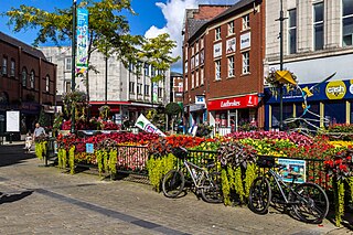
Oldham is a town in Greater Manchester, England, it lies amongst the Pennines on elevated ground between the rivers Irk and Medlock, 5 miles (8.0 km) southeast of Rochdale, and 7 miles (11.3 km) northeast of Manchester. It is the administrative centre of the Metropolitan Borough of Oldham, which had a population of 237,110 in 2019.

<span class="mw-page-title-main">Chadderton</span> Town in Greater Manchester

Chadderton is a town in the Metropolitan Borough of Oldham, Greater Manchester, England, on the River Irk and Rochdale Canal. It is located in the foothills of the Pennines, 1 mile (1.6 km) west of Oldham, 5 miles (8.0 km) south of Rochdale and 6 miles (9.7 km) north-east of Manchester.

<span class="mw-page-title-main">Moston, Manchester</span> Human settlement in England

Moston is a suburb of Manchester, in North West England, approximately 3 miles (4.8 km) north-east of the city centre. Historically in Lancashire, Moston is a predominantly residential area, with a population of 14,518 at the 2011 census and an area of approximately 1,300 acres (5.3 km2).

<span class="mw-page-title-main">Hollinwood, Greater Manchester</span> Human settlement in England

Hollinwood is an area and electoral ward of the Metropolitan Borough of Oldham, Greater Manchester, England. The population at the 2011 census was 10,920.

<span class="mw-page-title-main">Oldham Werneth railway station</span> Former railway station in England

Oldham Werneth railway station was situated on the Oldham Loop Line, 6+14 miles (10 km) northeast of Manchester Victoria. The station was situated on Featherstall Road South, in the Werneth area of Oldham, in Greater Manchester, England. Opened on 31 March 1842 it was the oldest of the six railway stations that at one time existed in Oldham.

<span class="mw-page-title-main">Werneth, Greater Manchester</span> Human settlement in England

Werneth is an area of Oldham, Greater Manchester, England. The population at the 2011 census was 12,348. It is 1 mile (1.6 km) west-southwest of Oldham's commercial centre and one of its most ancient localities. It is contiguous with Westwood, Hollinwood, Hollins and Chadderton. Werneth includes Freehold between Werneth Park and Oldham's border with Chadderton at Block Lane.

<span class="mw-page-title-main">Freehold tram stop</span> Manchester Metrolink tram stop

Freehold is a tram stop on the Oldham and Rochdale Line (ORL) of Greater Manchester's light-rail Metrolink system. It opened to passengers on 13 June 2012 as part of Phase 3a of the system's expansion, and is located on Block Lane in Chadderton at its boundary with Oldham in the Metropolitan Borough of Oldham, England.

<span class="mw-page-title-main">New Moston</span> Human settlement in England

New Moston is a suburb of Manchester, England.

<span class="mw-page-title-main">Mills Hill</span> Human settlement in England

Mills Hill is an industrial and residential area that lies on the common border of Middleton and Chadderton in Greater Manchester, England. It lies 1.3 miles east of Middleton town centre and 1.4 miles to the west of central Chadderton. It is contiguous with Middleton Junction, Moorclose, Firwood Park and Chadderton Park. Mills Hill lies along the course of the Rochdale Canal and the River Irk.

<span class="mw-page-title-main">Cowhill, Greater Manchester</span> Human settlement in England

Cowhill is a locality of Chadderton, in the Metropolitan Borough of Oldham, Greater Manchester, England.

<span class="mw-page-title-main">Freehold, Greater Manchester</span> Human settlement in England

Freehold is an urban area of Werneth in Oldham, Greater Manchester, England. It occupies an area in the west of Werneth along the Oldham township boundary with Chadderton. It is contiguous on all sides with other urban areas, including parts of Werneth to the north and east, and Cowhill, Block Lane, and Butler Green/Washbrook in Chadderton.

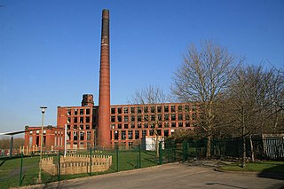
Whitegate is an industrial and residential district of the town of Chadderton in the Metropolitan Borough of Oldham, Greater Manchester, England.

<span class="mw-page-title-main">Coalshaw Green</span> Human settlement in England

Coalshaw Green is a locality in the town of Chadderton in the Metropolitan Borough of Oldham, Greater Manchester.

<span class="mw-page-title-main">Butler Green</span> Human settlement in England

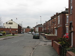
Butler Green is a residential area in the town of Chadderton in the Metropolitan Borough of Oldham, Greater Manchester. The area is also commonly known as Washbrook.

<span class="mw-page-title-main">Nimble Nook</span> Human settlement in England


Nimble Nook is a locality in the town of Chadderton in the Metropolitan Borough of Oldham, Greater Manchester.

<span class="mw-page-title-main">Stock Brook</span> Human settlement in England

Stock Brook is a residential and industrial area in the town of Chadderton in the Metropolitan Borough of Oldham, Greater Manchester, England. It is contiguous with Chadderton's town centre area and with Nimble Nook, Cowhill and Nordens.

<span class="mw-page-title-main">Middleton Junction</span> Human settlement in England

Middleton Junction is an industrial and residential district lying on the common border of Middleton in the Metropolitan Borough of Rochdale and Chadderton in the Metropolitan Borough of Oldham, Greater Manchester.

<span class="mw-page-title-main">Nordens</span> Human settlement in England

Nordens is a suburban area of Chadderton in the Metropolitan Borough of Oldham, Greater Manchester.

<span class="mw-page-title-main">Oldham and Rochdale Line</span> Manchester Metrolink line

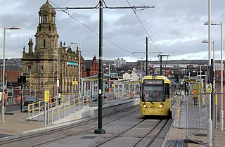
The Oldham and Rochdale Line (ORL) is a tram line of the Manchester Metrolink in Greater Manchester running from Manchester city centre to Rochdale town centre via Oldham, using most of the trackbed of the former Oldham Loop Line which closed in 2009. The line was re-opened in a modified form as a tramway between 2012 and 2014, as part of phase three of the system's expansion.

References

  1. "The parish of Prestwich with Oldham - Chadderton | A History of the County of Lancaster: Volume 5 (pp. 115-121)". British-history.ac.uk. 22 June 2003. Retrieved 29 June 2013.
  2. 1 2 P.26 Chadderton Pubs And Their Licencees 1750 - 1999, Magee Rob (1986) ISBN   978 185216 134 7
  3. "the online repository of historic maps - maps page". Old-Maps. Archived from the original on 24 June 2013. Retrieved 29 June 2013.
  4. http://www.pixnet.co.uk/Oldham-hrg/miscellany/butterworth-history-Oldham/pages/052.html |Oldham Historical Research Group|Retrieved 21 January 2020
  5. 1 2 P.29 Chadderton Pubs And Their Licencees 1750 - 1999, Magee Rob (1986) ISBN   978 185216 134 7
  6. P53 Gurr, Duncan; Hunt, Julian (1998), The Cotton Mills of Oldham, Oldham Education & Leisure, ISBN   0-902809-46-6
  7. "FROM THE LONDON GAZETTES. » 9 Aug 1828 » the Spectator Archive". archive.spectator.co.uk. Retrieved 29 October 2018.
  8. "FreeUK - Customer information". November 2017. Archived from the original on 28 January 2001.
  9. "Listed Buildings in Chadderton". Chadderton-historical-society.org.uk. 18 February 2012. Retrieved 29 June 2013.
  10. www.christchurchchadderton.co.uk http://www.christchurchchadderton.co.uk/ . Retrieved 23 July 2017.{{cite web}}: Missing or empty |title= (help)[ title missing ]
  11. 1 2 Sidney F Cornell "The History of Christ Church Chadderton" 1920
  12. Hartwell, Clare; Hyde, Matthew; Pevsner, Nikolaus (2004), Lancashire: Manchester and the South-East, The Buildings of England, New Haven and London: Yale University Press, ISBN   0-300-10583-5 |Retrieved 3 June 2019
  13. "Transport for Greater Manchester - Journey Planning - Network Maps". Transport for Greater Manchester. Archived from the original on 2 November 2012. Retrieved 7 February 2014.
  14. "Service 152 Chadderton - Firwood Park" (PDF). Stagecoach Manchester. 7 February 2014. Archived from the original (PDF) on 2 November 2013. Retrieved 31 July 2013.
  15. "Pages - Latest Service Changes". Archived from the original on 16 November 2015. Retrieved 10 November 2015.
  16. "Freehold tram stop | Transport for Greater Manchester".