
Michigan City Municipal Airport is a public use airport located three nautical miles east of the central business district of Michigan City, in LaPorte County, Indiana, United States. The airport is publicly owned by the Michigan City Board of Aviation Commissioners.

Longville Municipal Airport is a city-owned public-use airport located one nautical mile (1.85 km) northeast of the central business district of Longville, a city in Cass County, Minnesota, United States.

Florence Municipal Airport, is a public airport located in the city of Florence in Lane County, Oregon, USA. It is mostly used for general aviation.

Elkhart Municipal Airport is a city-owned public-use airport located three nautical miles (6 km) northwest of the central business district of Elkhart, a city in Elkhart County, Indiana, United States.

Kissimmee Gateway Airport, formerly known as Kissimmee Municipal Airport, is a public airport in Kissimmee, a city in Osceola County, Florida, United States. The airport is located 16 nautical miles (30 km) southwest of the central business district of Orlando. It is owned and operated by the City of Kissimmee.

Livingston Municipal Airport is a city-owned public-use airport located two miles northeast of the central business district of Livingston, a city in Overton County, Tennessee, United States.
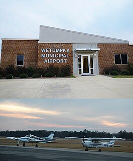
Wetumpka Municipal Airport is a city-owned, public-use airport located six nautical miles west of the central business district of Wetumpka, a city in Elmore County, Alabama, United States. It is included in the FAA's National Plan of Integrated Airport Systems for 2011–2015, which categorized it as a general aviation facility. During World War II the airport, known then as Elmore Auxiliary Field, served as an auxiliary field for Gunter Army Airfield training operations. In 2013 the airport was listed in the Alabama Register of Landmarks and Heritage.

Atmore Municipal Airport is a city-owned public-use airport located 3 nautical miles (6 km) east of the central business district of Atmore, a city in Escambia County, Alabama, United States. According to the FAA's National Plan of Integrated Airport Systems for 2009–2013, it is categorized as a general aviation facility.
Brewton Municipal Airport is a city-owned public-use airport located 3 nautical miles (6 km) south of the central business district of Brewton, a city in Escambia County, Alabama, United States. Originally constructed by the U.S. Navy during World War II as an auxiliary field to the Naval Air Station Pensacola complex, it was later redesignated as Navy Outlying Landing Field (NOLF) Brewton before being conveyed to the city of Brewton as a public use facility. Although under civilian ownership, the airfield still functions concurrently as NOLF Brewton and is used by Navy training aircraft located at Naval Air Station Whiting Field, Florida.
Greensboro Municipal Airport is a city-owned public-use airport located three nautical miles southwest of the central business district of Greensboro, a city in Hale County, Alabama, United States.

Scottsboro Municipal Airport, also known as Word Field, is a city-owned public-use airport located two nautical miles northeast of the central business district of Scottsboro, a city in Jackson County, Alabama, United States. According to the FAA's National Plan of Integrated Airport Systems for 2009–2013, it is categorized as a general aviation facility.
Deer Park Airport, formerly known as Deer Park Municipal Airport, is a city-owned public-use airport located three nautical miles (6 km) northeast of the central business district of Deer Park, a city in Spokane County, Washington, United States.

Independence Municipal Airport is a city-owned public-use airport located three nautical miles (6 km) southwest of the central business district of Independence, a city in Buchanan County, Iowa, United States. As per the FAA's National Plan of Integrated Airport Systems for 2009-2013, it is classified as a general aviation airport.
Humboldt Municipal Airport is a city-owned public-use airport located one nautical mile (1.85 km) west of the central business district of Humboldt, a city in Humboldt County, Iowa, United States. According to the FAA's National Plan of Integrated Airport Systems for 2009–2013, it is classified as a general aviation airport.
Bloomfield Municipal Airport is a public use airport located two nautical miles southwest of the central business district of Bloomfield, a city in Knox County, Nebraska, United States. It is owned by the Bloomfield Airport Authority.
Eutaw Municipal Airport is a city-owned, public-use airport located two nautical miles southeast of the central business district of Eutaw, a city in Greene County, Alabama, United States. As of 8 December 2017, the airport is now indefinitely closed.

Eureka Municipal Airport, also known as Lt. William M. Milliken Airport, is a city-owned, public-use airport located two nautical miles (4 km) north of the central business district of Eureka, a city in Greenwood County, Kansas, United States. It is included in the National Plan of Integrated Airport Systems for 2011–2015, which categorized it as a general aviation facility.
Stanton County Municipal Airport is a county-owned, public-use airport in Stanton County, Kansas, United States. It is located two nautical miles (4 km) northeast of the central business district of Johnson, Kansas, which is also known as Johnson City. This airport included in the National Plan of Integrated Airport Systems for 2011–2015, which categorized it as a general aviation facility.

Park Falls Municipal Airport is a city owned public use airport located two nautical miles (4 km) northeast of the central business district of Park Falls, a city in Price County, Wisconsin, United States. It is included in the Federal Aviation Administration (FAA) National Plan of Integrated Airport Systems for 2019–2023, in which it is categorized as a basic general aviation facility.
Marion Municipal Airport is a city-owned, public-use airport located two nautical miles (4 km) southeast of the central business district of Marion, a city in Marion County, Kansas, United States.


