Independence Municipal Airport (Iowa)

Last updated
Independence Municipal Airport
Summary
Airport type Public
Owner City of Independence
Serves Independence, Iowa
Elevation  AMSL 979 ft / 298 m
Coordinates 42°27′25″N091°56′52″W / 42.45694°N 91.94778°W / 42.45694; -91.94778
Map
USA Iowa location map.svg
Airplane silhouette.svg
IIB
Location of airport in Iowa/United States
Usa edcp relief location map.png
Airplane silhouette.svg
IIB
IIB (the US)
Runways
Direction LengthSurface
ftm
18/365,5001,676Concrete
Statistics (2009)
Aircraft operations 9,100
Based aircraft 24

Independence Municipal Airport( ICAO : KIIB, FAA LID : IIB) is a city-owned public-use airport located three nautical miles (6 km) southwest of the central business district of Independence, a city in Buchanan County, Iowa, United States. [1] As per the FAA's National Plan of Integrated Airport Systems for 2009-2013, it is classified as a general aviation airport. [2]

ICAO airport code four-letter code designating many airports around the world

The ICAOairport code or location indicator is a four-letter code designating aerodromes around the world. These codes, as defined by the International Civil Aviation Organization and published in ICAO Document 7910: Location Indicators, are used by air traffic control and airline operations such as flight planning.

Federal Aviation Administration United States Government agency dedicated to civil aviation matters

The Federal Aviation Administration (FAA) is a governmental body of the United States with powers to regulate all aspects of civil aviation in that nation as well as over its surrounding international waters. Its powers include the construction and operation of airports, air traffic management, the certification of personnel and aircraft, and the protection of U.S. assets during the launch or re-entry of commercial space vehicles. Powers over neighboring international waters were delegated to the FAA by authority of the International Civil Aviation Organization.

A location identifier is a symbolic representation for the name and the location of an airport, navigation aid, or weather station, and is used for manned air traffic control facilities in air traffic control, telecommunications, computer programming, weather reports, and related services.

Contents

Although most U.S. airports use the same three-letter location identifier for the FAA and IATA, this airport is assigned IIB by the FAA but has no designation from the IATA. [3]

International Air Transport Association trade group of airlines

The International Air Transport Association is a trade association of the world’s airlines. Consisting of 290 airlines, primarily major carriers, representing 117 countries, the IATA's member airlines account for carrying approximately 82% of total available seat miles air traffic. IATA supports airline activity and helps formulate industry policy and standards. It is headquartered in Montreal, Quebec, Canada with Executive Offices in Geneva, Switzerland.

Facilities and aircraft

Independence Municipal Airport covers an area of 161 acres (65 ha) at an elevation of 979 feet (298 m) above mean sea level. It has one runway designated 18/36 with a concrete surface measuring 5,500 by 100 feet (1,676 x 30 m). [1]

Elevation Height of a geographic location above a fixed reference point

The elevation of a geographic location is its height above or below a fixed reference point, most commonly a reference geoid, a mathematical model of the Earth's sea level as an equipotential gravitational surface . The term elevation is mainly used when referring to points on the Earth's surface, while altitude or geopotential height is used for points above the surface, such as an aircraft in flight or a spacecraft in orbit, and depth is used for points below the surface.

Runway Area of surface used by aircraft to takeoff from and land on

According to the International Civil Aviation Organization (ICAO), a runway is a "defined rectangular area on a land aerodrome prepared for the landing and takeoff of aircraft". Runways may be a man-made surface or a natural surface.

For the 12-month period ending March 26, 2009, the airport had 9,100 aircraft operations, an average of 24 per day: 87% general aviation, 12% military and 1% air taxi. At that time there were 24 aircraft based at this airport: 79% single-engine, 4% multi-engine and 17% ultralight. [1]

General aviation civil use of aircraft excluding commercial transportation

General Aviation (GA) represents the 'private transport' and recreational flying component of aviation.

Military aviation use of aircraft by armed forces in combat or other military capacity

Military aviation is the use of military aircraft and other flying machines for the purposes of conducting or enabling aerial warfare, including national airlift capacity to provide logistical supply to forces stationed in a theater or along a front. Airpower includes the national means of conducting such warfare, including the intersection of transport and war craft. Military aircraft include bombers, fighters, transports, trainer aircraft, and reconnaissance aircraft.

Air taxi on-demand commercial air transportation, particularly of smaller quantities of passenger or cargo by aeroplane or helicopter

An air taxi is a small commercial aircraft which makes short flights on demand.

Related Research Articles

Clarion Municipal Airport airport in Iowa, United States of America

Clarion Municipal Airport is a city-owned public-use airport located one nautical mile (1.85 km) northwest of the central business district of Clarion, a city in Wright County, Iowa, United States. This airport is included in the FAA's National Plan of Integrated Airport Systems for 2009–2013, which categorized it as a general aviation facility.

Gastonia Municipal Airport airport in North Carolina, United States of America

Gastonia Municipal Airport is a city-owned, public-use airport located four nautical miles south of the central business district of Gastonia, a city in Gaston County, North Carolina, United States. It is included in the National Plan of Integrated Airport Systems for 2011–2015, which categorized it as a general aviation facility.

Scappoose Industrial Airpark airport in Oregon, United States of America

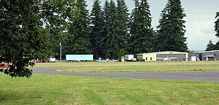
Scappoose Industrial Airpark is a public use airport located one nautical mile (1.85 km) northeast of the central business district of Scappoose, in Columbia County, Oregon, United States. It is owned and operated by the Port of Columbia County, an Oregon port district and municipal corporation, on behalf of district residents. According to the FAA's National Plan of Integrated Airport Systems for 2009–2013, it is categorized as a general aviation airport.

Council Bluffs Municipal Airport airport in Iowa, United States of America

Council Bluffs Municipal Airport is a public use airport located four nautical miles east of the central business district of Council Bluffs, a city in Pottawattamie County, Iowa, United States. It is owned by Council Bluffs Airport Authority. This airport is included in the National Plan of Integrated Airport Systems for 2011–2015, which categorized it as a general aviation facility.

Keokuk Municipal Airport airport in Iowa, United States of America

Keokuk Municipal Airport is five miles northwest of Keokuk, in Lee County, Iowa. The National Plan of Integrated Airport Systems for 2017–2021 categorized it as a general aviation facility.

Independence Municipal Airport (Kansas) airport in Kansas, United States of America

Independence Municipal Airport is six miles southwest of Independence, in Montgomery County, Kansas. The National Plan of Integrated Airport Systems for 2011–2015 categorized it a general aviation facility.

Marianna Municipal Airport airport

Marianna Municipal Airport is five miles northeast of Marianna, in Jackson County, Florida. The FAA's National Plan of Integrated Airport Systems for 2009–2013 categorized it as a general aviation airport. It was formerly Graham Air Base.

Clinton Municipal Airport (Iowa) airport in Iowa, United States of America

Clinton Municipal Airport is seven miles southwest of Clinton, in Clinton County, Iowa. The FAA's National Plan of Integrated Airport Systems (2017-2021) categorizes it as a general aviation airport.

Shelbyville Municipal Airport (Indiana) airport in Indiana, United States

Shelbyville Municipal Airport is a public use airport located four nautical miles (7 km) northwest of the central business district of Shelbyville, in Shelby County, Indiana, United States. The airport is owned by the city of Shelbyville and is controlled by the mayor and an appointed Board of Commissioners. According to the FAA's National Plan of Integrated Airport Systems for 2009–2013, it was classified as a general aviation airport.

Monett Municipal Airport is a public-use airport located in Barry County, Missouri, United States. It is five nautical miles (9 km) west of the central business district of the City of Monett, which owns the airport. According to the FAA's National Plan of Integrated Airport Systems for 2009–2013, it was classified as a general aviation airport.

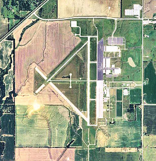
Guymon Municipal Airport is in Texas County, Oklahoma, two miles west of Guymon, which owns it. The FAA's National Plan of Integrated Airport Systems for 2009-2013 classified it as a general aviation airport.

Centerville Municipal Airport (Iowa) airport in Iowa, United States of America

Centerville Municipal Airport is a city-owned public-use airport located three nautical miles (6 km) southwest of the central business district of Centerville, a city in Appanoose County, Iowa, United States. According to the FAA's National Plan of Integrated Airport Systems for 2009–2013, it is categorized as a general aviation airport.

Red Oak Municipal Airport airport in Iowa, United States of America

Red Oak Municipal Airport is a city-owned public-use airport located two nautical miles (3.7 km) west of the central business district of Red Oak, a city in Montgomery County, Iowa, United States. According to the FAA's National Plan of Integrated Airport Systems for 2009–2013, it is categorized as a general aviation facility.

Mount Pleasant Municipal Airport (Iowa) airport in Iowa, United States of America

Mount Pleasant Municipal Airport is a city-owned public-use airport located three nautical miles southeast of the central business district of Mount Pleasant, a city in Henry County, Iowa, United States. According to the FAA's National Plan of Integrated Airport Systems for 2009–2013, it is categorized as a general aviation facility.

Orange City Municipal Airport airport in Iowa, United States of America

Orange City Municipal Airport is a city-owned public-use airport located one nautical mile (1.85 km) south of the central business district of Orange City, a city in Sioux County, Iowa, United States. This airport is included in the FAA's National Plan of Integrated Airport Systems for 2009–2013, which categorized it as a general aviation facility.

Goshen Municipal Airport airport in Indiana, United States of America

Goshen Municipal Airport is a public use airport located three nautical miles (6 km) southeast of the central business district of Goshen, a city in Elkhart County, Indiana, United States. It is owned by the Goshen Board of Aviation Commissioners. This airport is included in the National Plan of Integrated Airport Systems for 2011–2015, which categorized it as a general aviation facility.

Boone Municipal Airport airport in Iowa, United States of America

Boone Municipal Airport is a city-owned public-use airport located two nautical miles (4 km) southeast of the central business district of Boone, a city in Boone County, Iowa, United States. It is included in the National Plan of Integrated Airport Systems for 2011–2015, which categorized it as a general aviation facility.

Creston Municipal Airport airport in Iowa, United States of America

Creston Municipal Airport is a city-owned public-use airport located three nautical miles (6 km) south of the central business district of Creston, a city in Union County, Iowa, United States. It is included in the National Plan of Integrated Airport Systems for 2011–2015, which categorized it as a general aviation facility.

Denison Municipal Airport airport in Iowa, United States of America

Denison Municipal Airport is a city-owned, public-use airport located two nautical miles (4 km) southwest of the central business district of Denison, a city in Crawford County, Iowa, United States. It is included in the National Plan of Integrated Airport Systems for 2011–2015, which categorized it as a general aviation facility.

Webster City Municipal Airport airport in Iowa, United States of America

Webster City Municipal Airport is a city-owned public-use airport located three nautical miles (6 km) southwest of the central business district of Webster City, in Hamilton County, Iowa, United States. It is included in the National Plan of Integrated Airport Systems for 2015–2019, which categorized it as a general aviation facility.

References

  1. 1 2 3 4 FAA Airport Master Record for IIB ( Form 5010 PDF ). Federal Aviation Administration. Effective 27 Aug 2009.
  2. FAA National Plan of Integrated Airport Systems: 2009–2013 Archived August 6, 2011, at the Wayback Machine .
  3. KIIB - Independence, Iowa - Independence Municipal Airport. Great Circle Mapper. Accessed 20 Feb 2010.
The National Map

The National Map is a collaborative effort of the United States Geological Survey (USGS) and other federal, state, and local agencies to improve and deliver topographic information for the United States. The purpose of the effort is to provide "...a seamless, continuously maintained set of public domain geographic base information that will serve as a foundation for integrating, sharing, and using other data easily and consistently".