Bluehole was a post office in Clay County, Kentucky, United States on Buzzard Creek, a tributary of Collins Creek.[2] Established on 1916-08-04, originally it was going to be named Gladys, the name preferred by its first postmaster Charles S. Townsley.[2] However, that name clashed with a postoffice in Lawrence County and his next preference was Bluehole (after the common Kentucky geographic feature of a blue hole).[2]
It was originally located 2.5 miles (4.0km) up Buzzard Creek, at approximately the site of the Lower Buzzard School, but only lasted at that location until its first closure in August 1917.[2] Its next postmaster, Ella Perkins, re-located it nearer to the new railway station of Rodonnel, placing it 2 miles (3.2km) up Collins Creek on 1918-05-01, and from then until its closure in 1985 it was located at several places along Collins Creek and Kentucky Route 11.[2]
The name is still used informally for the area where the various postoffices were, rather than the name of the railway station.[2]
Clay County is a county located in the U.S. state of Kentucky. As of the 2010 census, the population was 21,730. Its county seat is Manchester. The county was formed in 1807 and named in honor of Green Clay (1757–1826). Clay was a member of the Virginia and Kentucky State legislatures, first cousin once removed of Henry Clay, U.S. Senator from Kentucky and Secretary of State in the 19th century.
Manchester is a home rule-class city in Clay County, Kentucky, in the United States. It is the seat of its county and the home of a minimum- and medium-security federal prison. The city's population was 1,255 at the 2010 census.
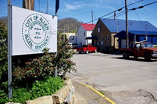
Allen is a home rule-class city in Floyd County, Kentucky, in the United States. The population was 193 at the 2010 census, up from 150 at the 2000 census.
Crab Orchard is a home rule-class city in Lincoln County, Kentucky, United States. The population was 841 at the 2010 census. It is part of the Danville Micropolitan Statistical Area.
Gratz is a home rule-class city in Owen County, Kentucky, in the United States. The population was 89 at the 2000 census. The population in 2010 was 78.
Prospect is a home rule-class city in Jefferson and Oldham counties in the U.S. state of Kentucky. The Jefferson County portion is a part of the Louisville Metro government. The population was 4,698 at the time 2010 census. It is one of the wealthiest communities in Kentucky.
Millville is an unincorporated community located in Woodford County, Kentucky. It is situated about 5 miles (8 km) southeast of Frankfort, Kentucky. Glenns Creek runs through the town, and it is near the Kentucky River.
Glendale is an unincorporated community in Hardin County, Kentucky, United States. It is included in the Elizabethtown, Kentucky Metropolitan Statistical Area.
Coxs Creek is an unincorporated community along U.S. Routes 31E/150 in Nelson County, Kentucky, United States, 4½ miles north of the county seat of Bardstown. It is named for Colonel Isaac Cox of Pennsylvania, who built a "fort" at the site in April 1775 before he fought in the American Revolutionary War, with the help of his brother James. The land had actually been his father's, but David moved back to Virginia before he developed it. More of a station, Cox's 1,000 acres (4.0 km2) was said to be the first pioneer station in Nelson County. Isaac Cox would later be the last white man to be killed by Indians during the time of the great Indian wars in what later became Kentucky.
Beaverlick is an unincorporated community in Boone County, Kentucky, United States. Beaverlick is located along U.S. Route 42 and U.S. Route 127 4.5 miles (7.2 km) west of Walton. The community was established as a fur trading site between 1780 and 1820. The community was founded sometime in the early 1800s. A post office was established at Beaver Lick in 1854 with John Tucker its postmaster. The post office closed in 1944.
'Knob Lick' is an unincorporated community in Metcalfe County, Kentucky, United States. Knob Lick is located on Kentucky Route 70, 8 miles (13 km) northwest of Edmonton. Knob Lick has a post office with ZIP code 42154.
Williba is an unincorporated community in Lee County, Kentucky, United States, located on Fraley Creek, one-half mile from the confluence of the North Fork and the Kentucky River.
Brightshade was a post office in Clay County, Kentucky, United States at various locations along Goose Creek.
Eriline was a post office in Clay County, Kentucky, United States from 1902-12-09 to 1988, with a 32-year hiatus from 1911. It was supposed to be named after Eveline Britton (1861–1939), wife of Van Britton (1855–1911) its first postmaster, but the clerks at the USPS could not read the handwriting on the application form, naming it Eriline instead, and the Brittons did not consider it important enough to make a fuss about the name.
Buchanan, originally named Mouth of Bear, is an unincorporated community located in Lawrence County, Kentucky, United States at the mouth of Bear Creek where it joins the Big Sandy River, five miles downstream from the mouth of Blaine Creek.
McQuady is an unincorporated community in Breckinridge County, Kentucky, United States. McQuady is located at the junction of Kentucky Route 105 and Kentucky Route 261, 5.9 miles (9.5 km) south-southwest of Hardinsburg. McQuady has a post office with ZIP code 40153.
Big Creek is a 4.5 miles (7.2 km) long creek in Kentucky, United States whose headwaters are in Leslie County and that flows into the Red Bird River in Clay County. A postoffice and village are named for it. Its own name is likely purely descriptive of its frequent flooding and high water levels, as it is not otherwise one of the biggest tributaries of Red Bird River.
Fall Rock is an unincorporated community in Clay County, Kentucky, United States. Fall Rock is located on U.S. Route 421 4.8 miles (7.7 km) north-northwest of Manchester. Fall Rock has a post office with ZIP code 40932, which opened on May 22, 1924.
Kettle Island is an unincorporated community and coal town in Bell County, Kentucky, United States. Kettle Island is located on Kentucky Route 1630 near Kentucky Route 221, 5.35 miles (8.61 km) east-northeast of Pineville. Kettle Island has a post office with ZIP code 40958, which opened on March 15, 1912. The community also had a station on the Louisville and Nashville Railroad.
Barcreek was a post office in Clay County, Kentucky, half a mile upriver on Bear Creek from its confluence wth the Red Bird River.
This page is based on this Wikipedia article Text is available under the CC BY-SA 4.0 license; additional terms may apply. Images, videos and audio are available under their respective licenses.