Bogota, Tennessee

Last updated

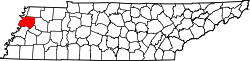
Bogota is a small farming community in Dyer County, Tennessee. It is located ten miles northwest of Dyersburg. Bogota was formerly home to Bogota Elementary School. Its zip code is 38007.

Population is 89 according to the 2020 census. The Post Office within walking distance of most of the 89 inhabitants, ZIP 38007. [ citation needed ]

The community is near the Obion River, several miles inland from the Mississippi River. [1] The 2,293-acre (928 ha) Bogota Wildlife Management Area is one of several waterfowl hunting areas that the Tennessee Wildlife Resources Agency maintains in the Obion River floodplain. [2] [3] Flood waters reached Bogota in May 2011 when the Mississippi River flooded. [1] [4]

Bogota was mentioned in the NBC show Third Watch in season 6, episode 15, "Revelations," which originally aired on February 11, 2005. A Vietnam War-era American soldier said on his death bed that he had only wanted to grow wheat on the family farm in Bogota.[ citation needed ]

Related Research Articles

<span class="mw-page-title-main">Weakley County, Tennessee</span> County in Tennessee, United States

Weakley County is a county located in the northwest of the U.S. state of Tennessee. As of the 2020 census, the population was 32,902. Its county seat is Dresden. Its largest city is Martin, the home of the University of Tennessee at Martin. The county was established by the Tennessee General Assembly on October 21, 1823, and is named for U.S. Congressman Robert Weakley (1764–1845). Weakley County comprises the Martin, TN Micropolitan Statistical Area.

<span class="mw-page-title-main">Obion County, Tennessee</span> County in Tennessee, United States

Obion County is a county located in the northwest corner of the U.S. state of Tennessee. As of the 2020 census, the population was 30,787. The county seat is Union City. The county was formed in 1823 and organized in 1824. It was named after the Obion River.

<span class="mw-page-title-main">Lauderdale County, Tennessee</span> County in Tennessee, United States

Lauderdale County is a county located on the western edge of the U.S. state of Tennessee, with its border the Mississippi River. As of the 2020 census, the population was 25,143. Its county seat is Ripley. Since the antebellum years, it has been developed for cotton as a major commodity crop.

<span class="mw-page-title-main">Lake County, Tennessee</span> County in Tennessee, United States

Lake County is a county located in the northwest corner of the U.S. state of Tennessee. As of the 2020 census, the population was 7,005, making it the fifth-least populous county in Tennessee. Its county seat is Tiptonville. It shares a border with Kentucky to the north and is separated from Missouri to the west by the Mississippi River.

<span class="mw-page-title-main">Hickman County, Tennessee</span> County in Tennessee, United States

Hickman County is a county located in the U.S. state of Tennessee. As of the 2020 Census, the population was 24,925. Its county seat is Centerville. Hickman County was part of the Nashville–Davidson–Murfreesboro–Franklin, TN Metropolitan Statistical Area but was removed in September 2018.

<span class="mw-page-title-main">Gibson County, Tennessee</span> County in Tennessee, United States

Gibson County is a county located in the U.S. state of Tennessee. As of the 2020 census, the population was 50,429. Its county seat is Trenton. The county was formed in 1823 and named for John H. Gibson, a soldier of the Natchez Expedition and the Creek War.

<span class="mw-page-title-main">Dyer County, Tennessee</span> County in Tennessee, United States

Dyer County is a county located in the westernmost part of the U.S. state of Tennessee. As of the 2020 census, the population was 36,801. The county seat is Dyersburg. Dyer County comprises the Dyersburg, TN Micropolitan Statistical Area.

<span class="mw-page-title-main">Wolf River (Tennessee)</span> Water course in Mississippi and Tennessee, United States

The Wolf River is a 105-mile-long (169 km) alluvial river in western Tennessee and northern Mississippi, whose confluence with the Mississippi River was the site of various Chickasaw, French, Spanish and American communities that eventually became Memphis, Tennessee. It is estimated to be about 12,000 years old, formed by Midwestern glacier runoff carving into the region's soft alluvial soil. It should not be confused with The Wolf River which flows primarily in Middle Tennessee and southern Kentucky. The Wolf River rises in the Holly Springs National Forest at Baker's Pond in Benton County, Mississippi, and flows northwest into Tennessee, before entering the Mississippi River north of downtown Memphis.

<span class="mw-page-title-main">Obion River</span> River in Tennessee, USA

The Obion River system is the primary surface water drainage system of northwestern Tennessee, United States.

<span class="mw-page-title-main">Piney River (Middle Tennessee)</span> River in Tennessee, United States

The Piney River is a 23.7-mile-long (38.1 km) tributary of the Duck River in Middle Tennessee in the United States. Via the Duck River, the Tennessee River, and the Ohio River, it is part of the Mississippi River watershed. The headwater tributaries of the Piney River rise in Dickson County, Tennessee, near the city of Dickson. Dickson is located on the "Tennessee Valley Divide", which corresponds for some distance with the downtown's Main Street. The western part of the town, the part in the Tennessee Valley, is drained by the East Piney River, a tributary to the Piney.

The Barren Fork is a 23.4-mile-long (37.7 km) tributary of the Collins River in the U.S. state of Tennessee. Via the Collins River, the Caney Fork, and the Cumberland and Ohio rivers, it is part of the Mississippi River watershed.

The Big Sandy River is a 60-mile-long (97 km) tributary of the Tennessee River in the U.S. state of Tennessee. Via the Tennessee and Ohio rivers, it is part of the Mississippi River watershed. The Big Sandy rises about 5 miles (8 km) northwest of Lexington, in the same vicinity as two other important rivers of West Tennessee, the Beech River and the Middle Fork of the Forked Deer River.

<span class="mw-page-title-main">Powell River (Tennessee River tributary)</span> River in Tennessee, United States

The Powell River is a 195-mile-long river in the United States that rises in Southwest Virginia and flows southwest into East Tennessee.

<span class="mw-page-title-main">Dyersburg State Community College</span> College in Dyersburg, Tennessee, U.S.

Dyersburg State Community College is a public community college in Dyersburg, Tennessee. It was founded in 1969 and serves nine counties in West Tennessee: Crockett, Dyer, Haywood, Henry, Lake, Lauderdale, Obion, Tipton, and Weakley Counties. Dyersburg State is governed by the Tennessee Board of Regents.

<span class="mw-page-title-main">Dale Hollow Reservoir</span> Reservoir in Tennessee and Kentucky, United States

The Dale Hollow Reservoir is a reservoir situated on the Kentucky/Tennessee border. The lake is formed by the damming of the Obey River, 7.3 miles (11.7 km) above its juncture with the Cumberland River at river mile 380. Portions of the lake also cover the Wolf River. Dale Hollow is one of four major flood control reservoirs for the Cumberland; the others being Percy Priest Lake, Lake Cumberland, and Center Hill Lake. It is also the site of Dale Hollow Lake State Park on the north (Kentucky) side.

<span class="mw-page-title-main">Mississippi River Delta</span> Delta of the Mississippi River

The Mississippi River Delta is the confluence of the Mississippi River with the Gulf of Mexico in Louisiana, southeastern United States. The river delta is a three-million-acre area of land that stretches from Vermilion Bay on the west, to the Chandeleur Islands in the east, on Louisiana's southeastern coast. It is part of the Gulf of Mexico and the Louisiana coastal plain, one of the largest areas of coastal wetlands in the United States. The Mississippi River Delta is the 7th largest river delta on Earth (USGS) and is an important coastal region for the United States, containing more than 2.7 million acres of coastal wetlands and 37% of the estuarine marsh in the conterminous U.S. The coastal area is the nation's largest drainage basin and drains about 41% of the contiguous United States into the Gulf of Mexico at an average rate of 470,000 cubic feet per second.

<span class="mw-page-title-main">Douglas Dam</span> Dam in Tennessee, United States

Douglas Dam is a hydroelectric dam on the French Broad River in Sevier County, Tennessee, in the southeastern United States. The dam is operated by the Tennessee Valley Authority (TVA), which built the dam in record time in the early 1940s to meet emergency energy demands at the height of World War II. Douglas Dam is a straight reinforced concrete gravity-type dam 1705 feet long and 202 feet high, impounding the 28,420-acre (11,500 ha) Douglas Lake. The dam was named for Douglas Bluff, a cliff overlooking the dam site prior to construction.

<span class="mw-page-title-main">Nonconnah Creek</span> River in Tennessee, United States

The Nonconnah Creek is a 29.7-mile-long (47.8 km) waterway in southwest Tennessee. It starts in extreme southeastern Shelby County, Tennessee, near the town of Collierville. From there, it flows westward, forming the southern border of Germantown. The creek continues to flow west through Memphis and through Whitehaven. Nonconnah Creek empties into McKellar Lake, an oxbow of the Mississippi River. There are three major expressways that follow most of its route. These are Interstate 55, Interstate 240, and Tennessee State Route 385, formerly named and still locally referred to as "Nonconnah Parkway".

<span class="mw-page-title-main">Randolph, Tennessee</span> Unincorporated community in Tennessee, United States

Randolph is a rural unincorporated community in Tipton County, Tennessee, United States, located on the banks of the Mississippi River. Randolph was founded in the 1820s and in 1827, the Randolph post office was established. In the 1830s, the town became an early center of river commerce in West Tennessee. Randolph shipped more cotton annually than Memphis until 1840. In 1834, the first pastor of the Methodist congregation was appointed. The fortunes of the community began to decline in the late 1840s due to failed railroad development, an unfavorable mail route and other factors. The first Confederate States Army fort in Tennessee was built at Randolph early in the Civil War in 1861, a second fortification at Randolph was constructed later that same year. During the Civil War, the town was burned down twice by Union Army forces.

Milburn is an unincorporated community in Carlisle County, Kentucky, United States. Its elevation is 482 feet (147 m), and it is located at 36°47′55″N88°53′59″W. Located along Kentucky Route 80 at its junction with Kentucky Routes 1371 and 1377, Milburn lies amid rolling countryside at the headwaters of Guess Creek, a tributary of Bayou du Chien; the nearest point on the Mississippi River is approximately 12 miles (19 km) to the west. Nearby cities include Arlington, 6 miles (9.7 km) by air to the west, and Bardwell, 8 miles (13 km) by air to the northwest; Milburn is connected to them by Kentucky Route 80 and Kentucky Route 1377 respectively. A state hunting preserve, the Obion Creek Wildlife Management Area, lies 2 miles (3.2 km) to the south. A fire station is located in Milburn, and a Creole cottage in the community, the George W. Stone House, is listed on the National Register of Historic Places.

References

  1. 1 2 Patrick Oppmann, 'Crazy old' Tennessee man waits out the flooding Archived December 8, 2011, at the Wayback Machine , CNN.com, May 10, 2011
  2. Jim W. Johnson (2007), Rivers under siege: the troubled saga of West Tennessee's wetlands, University of Tennessee Press. ISBN   1572334908. Pages 14-15.
  3. Tennessee's Watchable Wildlife: Bogota WMA Archived October 13, 2011, at the Wayback Machine , Tennessee Wildlife Resources Agency website, accessed September 2, 2011
  4. Lauren Vance, Mississippi River Floods Cause More Evacuations in Tennessee, ABC News, May 8, 2011

36°09′50″N89°26′18″W / 36.16389°N 89.43833°W / 36.16389; -89.43833