Lenox, Tennessee Coon Creek | |
|---|---|
 Lenox  Lenox | |
| Coordinates: 36°05′21″N89°29′54″W / 36.08917°N 89.49833°W | |
| Country | United States |
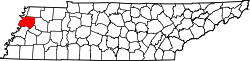
| State | Tennessee |
| County | Dyer |
| Area | |
• Total | 2.52 sq mi (6.53 km2) |
| • Land | 2.52 sq mi (6.53 km2) |
| • Water | 0 sq mi (0.00 km2) |
| Elevation | 292 ft (89 m) |
| Population | |
• Total | 308 |
| • Density | 122.2/sq mi (47.18/km2) |
| Time zone | UTC-6 (Central (CST)) |
| • Summer (DST) | UTC-5 (CDT) |
| ZIP code | 38047 |
| Area code | 731 |
| GNIS feature ID | 1291021 [2] |
Lenox is an unincorporated community in Dyer County, Tennessee, United States. [2] Its ZIP code is 38047. [4]