Newbern, Tennessee | |
---|---|
Motto: "Home of the Newbern Illinois Central Depot" | |
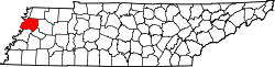
Coordinates: 36°6′59″N89°16′5″W / 36.11639°N 89.26806°W Coordinates: 36°6′59″N89°16′5″W / 36.11639°N 89.26806°W | |
Country | United States |
State | Tennessee |
County | Dyer |
Incorporated | 1857-1858 |
Government | |
• Type | Charter |
• Mayor | Pam Mabry [1] |
Area | |
• Total | 4.53 sq mi (11.74 km2) |
• Land | 4.53 sq mi (11.74 km2) |
• Water | 0.00 sq mi (0.00 km2) |
Elevation | 377 ft (115 m) |
Population | |
• Total | 3,349 |
• Density | 738.64/sq mi (285.18/km2) |
Time zone | UTC-6 (Central (CST)) |
• Summer (DST) | UTC-5 (CDT) |
ZIP code | 38059 |
Area code | 731 |
FIPS code | 47-52400 [5] |
GNIS feature ID | 1295678 [3] |
Website | http://www.cityofnewbern.org/ |
Newbern is a town in Dyer County, Tennessee. As of the 2010 census, the town population was 3,313.
In October 1902, Garfield Burley and Curtis Brown were lynched in downtown Newbern. Burley and Brown were tied together and hung from a telephone pole within sight of the town's train depot. The lynching is notable due to the efforts of several local community leaders to prevent it. [6]
On April 2, 2006, sixteen people were killed in Newbern when it and its surrounding communities were directly hit by an F3 tornado. The storm caused nearly $15 million in damages. [7] [8]
Newbern is located at 36°6′59″N89°16′5″W / 36.11639°N 89.26806°W (36.116460, -89.268099). [9]
According to the United States Census Bureau, the town has a total area of 4.8 square miles (12 km2), all land.
The climate in this area is characterized by hot, humid summers and generally mild to cool winters. According to the Köppen Climate Classification system, Newbern has a humid subtropical climate, abbreviated "Cfa" on climate maps. [10]
Climate data for Newbern, Tennessee | |||||||||||||
---|---|---|---|---|---|---|---|---|---|---|---|---|---|
Month | Jan | Feb | Mar | Apr | May | Jun | Jul | Aug | Sep | Oct | Nov | Dec | Year |
Average high °F (°C) | 47 (8) | 51 (11) | 60 (16) | 71 (22) | 80 (27) | 88 (31) | 91 (33) | 90 (32) | 84 (29) | 74 (23) | 60 (16) | 50 (10) | 70 (21) |
Average low °F (°C) | 28 (−2) | 31 (−1) | 38 (3) | 48 (9) | 57 (14) | 65 (18) | 68 (20) | 66 (19) | 59 (15) | 48 (9) | 38 (3) | 30 (−1) | 48 (9) |
Average precipitation inches (mm) | 4.5 (110) | 4 (100) | 5 (130) | 4.7 (120) | 4.6 (120) | 4 (100) | 4 (100) | 3.2 (81) | 3.4 (86) | 3.2 (81) | 4.3 (110) | 4.6 (120) | 49.5 (1,260) |
Source: Weatherbase [11] |
Historical population | |||
---|---|---|---|
Census | Pop. | %± | |
1880 | 506 | — | |
1890 | 1,236 | 144.3% | |
1900 | 1,433 | 15.9% | |
1910 | 1,602 | 11.8% | |
1920 | 1,767 | 10.3% | |
1930 | 1,621 | −8.3% | |
1940 | 1,740 | 7.3% | |
1950 | 1,734 | −0.3% | |
1960 | 1,695 | −2.2% | |
1970 | 2,124 | 25.3% | |
1980 | 2,794 | 31.5% | |
1990 | 2,515 | −10.0% | |
2000 | 2,988 | 18.8% | |
2010 | 3,313 | 10.9% | |
2020 | 3,349 | 1.1% | |
Sources: [12] [13] [4] |
Race | Num. | Perc. |
---|---|---|
White (non-Hispanic) | 2,491 | 74.38% |
Black or African American (non-Hispanic) | 459 | 13.71% |
Native American | 22 | 0.66% |
Asian | 18 | 0.54% |
Pacific Islander | 1 | 0.03% |
Other/Mixed | 164 | 4.9% |
Hispanic or Latino | 194 | 5.79% |
As of the 2020 United States Census, there were 3,349 people, 1,252 households, and 762 families residing in the town.
As of the census [5] of 2000, there were 2,988 people, 1,202 households, and 854 families residing in the town. The population density was 241.4/km2
There were 1,202 households, out of which 35.9% had children under the age of 18 living with them, 50.5% were married couples living together, 17.1% had a female householder with no husband present, and 28.9% were non-families. 26.1% of all households were made up of individuals, and 10.9% had someone living alone who was 65 years of age or older. The average household size was 2.48 and the average family size was 2.97.
In the town, the population was spread out, with 27.7% under the age of 18, 9.2% from 18 to 24, 29.0% from 25 to 44, 21.7% from 45 to 64, and 12.4% who were 65 years of age or older. The median age was 34 years. For every 100 females, there were 84.0 males. For every 100 females age 18 and over, there were 78.9 males.
The median income for a household in the town was $28,262, and the median income for a family was $36,853. Males had a median income of $28,393 versus $19,750 for females. The per capita income for the town was $15,575. About 14.6% of families and 16.7% of the population were below the poverty line, including 23.0% of those under age 18 and 13.9% of those age 65 or over.
The Newbern Depot houses a museum. The museum exhibits old photos, railroad tools, uniforms, schedules, and other memorabilia, along with model trains and artwork commemorating the town's railroading past. [15] On February 2, 2011 a truck was hit by a train at the crossing west of the depot. The semi landed within ten feet of the depot but caused no building damage. No one was reported injured in this event and the train itself acquired little damage, stopping prior to blocking the crossing located to the west of the depot. [16]
Every year, the town holds a celebration around the train depot called Depot Days. [17]
Dyer County is a county located in the westernmost part of the U.S. state of Tennessee. As of the 2020 census, the population was 36,801. The county seat is Dyersburg. Dyer County comprises the Dyersburg, TN Micropolitan Statistical Area.
Manila is a city in Mississippi County, Arkansas, United States. The population was 3,682 at the 2020 census, up from 3,342 in 2010. It was the hometown of World War I sniper Herman Davis. A park in the town honors his memory.
Bardwell is a home rule-class city in and the county seat of Carlisle County, Kentucky, United States. The city was formally incorporated by the state assembly in 1878. The population was 723 at the 2010 census, down from 799 in 2000.
Stearns is a census-designated place (CDP) in McCreary County, Kentucky, United States. The population was 1,586 at the 2000 census. It was founded by Justus Smith Stearns.
Wartrace is a town in Bedford County, Tennessee, United States. The population was 548 at the 2000 census and 651 at the 2010 census. It is located northeast of Shelbyville. The downtown area is listed on the National Register of Historic Places as the Wartrace Historic District.
Woodbury is a town in Cannon County, Tennessee, United States. Woodbury is part of the Nashville Metropolitan Statistical Area and is located 55 miles (89 km) southeast of downtown Nashville. The population of Woodbury was 2,680 at the 2010 census. It is the county seat of Cannon County.
New Tazewell is a city in Claiborne County, Tennessee, United States. The population was 3,037 at the 2010 census.The population was 2,769 at the 2020 census.
Tazewell is a town in and the county seat of Claiborne County, Tennessee, United States. The population was 2,165 at the 2000 census and 2,218 at the 2010 census, and 2,348 at the 2020 census.The town is named for Tazewell, Virginia, which itself was named for Henry Tazewell (1753–1799), a U.S. senator from Virginia.
Celina is a city in and the county seat of Clay County, Tennessee, United States. The population was 1,495 at the 2010 census.
Bells is a city in Crockett County, Tennessee. The population was 2,437 at the 2010 census.
Braden is a town in Fayette County, Tennessee. The population was 282 at the 2010 census. The town is named after Joseph P. Braden.
Centerville is a town in Hickman County, Tennessee, United States. The population was 3,489 as of the 2020 Census. It is the county seat and the only incorporated city or town in Hickman County. It is best known for being the hometown of country comedian Minnie Pearl.
Jefferson City is a city in Jefferson County, Tennessee, United States. It is part of the Morristown Metropolitan Statistical Area. As of the 2020 census the population was 8,419.
Tiptonville is a town in and the county seat of Lake County, Tennessee, United States. Its population was 2,439 as of the 2000 census and 4,464 in 2010, showing an increase of 2,025. It is also home to the Northwest Correctional Complex, a maximum security prison, known for once housing mass murderer Jessie Dotson.
Samburg is a town in Obion County, Tennessee, United States. The population was 210 at the 2020 census. Samburg is located on the eastern shores of Reelfoot Lake.
Union City is located in Obion County, Tennessee, United States. The 2020 census reported the population of the town as 11,170. It is the principal urban settlement of the surrounding micropolitan area, which includes Obion County and Fulton County, Kentucky. Union City is home to Discovery Park of America which is a world-renowned encyclopedic museum with many exhibits pertaining to local history, as well as state, national, and world history, science, technology, and art.
Portland is a city in Sumner and Robertson counties in Tennessee. The population was 11,486 in 2010 according estimates by the U.S. census bureau and in 2020 the population was 13,156. Portland is a part of the Nashville Metropolitan Statistical Area.
Dresden is a town in and the county seat of Weakley County, Tennessee, United States. The population was 3,005 at the 2010 census.
Trimble is a town in Dyer and Obion counties in the U.S. state of Tennessee. The population was 637 at the 2010 census.
Humboldt is a city in Gibson and Madison counties, Tennessee. The population was 8,452 at the 2010 census, a decline of 1,015 from 2000. It is the principal city of and is included in the Humboldt, Tennessee Micropolitan Statistical Area, which is included in the Jackson, Tennessee-Humboldt, Tennessee Combined Statistical Area.