Richmond is a town in Chittenden County, Vermont, United States. As of the 2020 census the population was 4,167. The main settlement of Richmond, in the north-central part of town, is a census-designated place (CDP), with a population of 853 at the 2020 census; it was formerly an incorporated village.

Underhill is a town in Chittenden County, Vermont, United States. The population was 3,129 at the 2020 census.

Jericho is a town in Chittenden County, Vermont, United States. As of the 2020 census, the population was 5,104. The town was named after the ancient city of Jericho.
West Rutland is the central village and a census-designated place (CDP) in the town of West Rutland, Rutland County, Vermont, United States. As of the 2020 census, it had a population of 1,898, out of 2,214 in the entire town of West Rutland.
East Charlotte is an unincorporated village and census-designated place (CDP) in the town of Charlotte, Chittenden County, Vermont, United States. It was first listed as a CDP prior to the 2020 census.
Waterbury Center is an unincorporated village and census-designated place (CDP) in the town of Waterbury, Washington County, Vermont, United States. As of the 2020 census, it had a population of 390.
Waitsfield is a census-designated place (CDP) in the town of Waitsfield, Washington County, Vermont, United States. The population of the CDP was 164 at the 2010 census.
Hinesburg is the primary village and a census-designated place (CDP) in the town of Hinesburg, Chittenden County, Vermont, United States. As of the 2020 census, it had a population of 872, out of 4,698 in the entire town of Hinesburg.
Richmond is the primary village and a census-designated place (CDP) in the town of Richmond, Chittenden County, Vermont, United States. As of the 2020 census, it had a population of 853, out of 4,167 in the entire town of Richmond.
Shelburne is a census-designated place (CDP) comprising the central village and surrounding suburban land in the town of Shelburne, Chittenden County, Vermont, United States. As of the 2020 census, the CDP had a population of 6,178, out of 7,717 in the entire town.
Stowe is a census-designated place (CDP) comprising the central community in the town of Stowe, Lamoille County, Vermont, United States. As of the 2010 census the population of the CDP was 495, out of 4,314 in the entire town.
Hanksville is an unincorporated village and census-designated place (CDP) in the town of Huntington, Chittenden County, Vermont, United States. It was first listed as a CDP prior to the 2020 census.
Huntington is an unincorporated village and census-designated place (CDP) in the town of Huntington, Chittenden County, Vermont, United States. It was first listed as a CDP prior to the 2020 census.
Huntington Center is an unincorporated village and census-designated place (CDP) in the town of Huntington, Chittenden County, Vermont, United States. It was first listed as a CDP prior to the 2020 census.
Williston is a census-designated place (CDP) in the town of St. George, Chittenden County, Vermont, United States. It was first listed as a CDP prior to the 2020 census.
Underhill Flats is an unincorporated village and census-designated place (CDP) in the towns of Underhill and Jericho, Chittenden County, Vermont, United States. It was first listed as a CDP prior to the 2020 census.
West Charlotte is an unincorporated village and census-designated place (CDP) in the town of Charlotte, Chittenden County, Vermont, United States. It was first listed as a CDP prior to the 2020 census.
Westford is the primary village and a census-designated place (CDP) in the town of Westford, Chittenden County, Vermont, United States. It was first listed as a CDP prior to the 2020 census.
Castleton Four Corners is a census-designated place (CDP) in the town of Castleton, Rutland County, Vermont, United States. It consists of the unincorporated villages of Castleton Corners and Hydeville. As of the 2020 census, the CDP had a population of 699, out of 4,458 in the entire town.
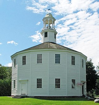
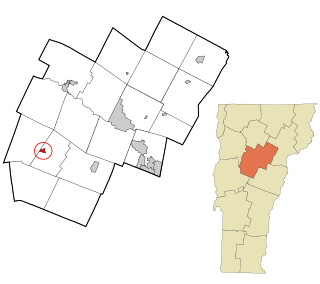
Chittenden is the primary village and a census-designated place (CDP) in the town of Chittenden, Rutland County, Vermont, United States. As of the 2020 census, it had a population of 136, out of 1,237 in the entire town.


