Utah is a landlocked state in the Mountain West subregion of the Western United States. It borders Colorado to its east, Wyoming to its northeast, Idaho to its north, Arizona to its south, and Nevada to its west. Utah also touches a corner of New Mexico in the southeast. Of the fifty U.S. states, Utah is the 13th-largest by area; with a population over three million, it is the 30th-most-populous and 11th-least-densely populated. Urban development is mostly concentrated in two areas: the Wasatch Front in the north-central part of the state, which is home to roughly two-thirds of the population and includes the capital city, Salt Lake City; and Washington County in the southwest, with more than 180,000 residents. Most of the western half of Utah lies in the Great Basin.

Salt Lake City, often shortened to Salt Lake or SLC, is the capital and most populous city of the U.S. state of Utah. It is the seat of Salt Lake County, the most populous county in the state. The city is the core of the Salt Lake City Metropolitan Statistical Area (MSA), which had a population of 1,257,936 at the 2020 census. Salt Lake City is further situated within a larger metropolis known as the Salt Lake City–Ogden–Provo Combined Statistical Area, a corridor of contiguous urban and suburban development stretched along a 120-mile (190 km) segment of the Wasatch Front, comprising a population of 2,746,164, making it the 22nd largest in the nation. With a population of 200,133 in 2020, it is the 117th most populous city in the United States. It is also the central core of the larger of only two major urban areas located within the Great Basin.
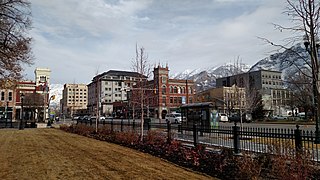
Provo is a city in and the county seat of Utah County, Utah, United States. It is 43 miles (69 km) south of Salt Lake City along the Wasatch Front, and lies between the cities of Orem to the north and Springville to the south. With a population at the 2020 census of 115,162, Provo is the fourth-largest city in Utah and the principal city in the Provo-Orem metropolitan area, which had a population of 526,810 at the 2010 census. It is Utah's second-largest metropolitan area after Salt Lake City.

Bountiful is a city in Davis County, Utah. As of the 2020 census, the city population was 45,762, an eight percent increase over the 2010 figure of 42,552. The city grew rapidly during the suburb growth of the late 1940s, 1950s, and 1960s and was Davis County's largest city until 1985, when it was surpassed by Layton. Bountiful is Utah's 18th-largest city.
Scipio is a town on the eastern edge of Millard County, Utah, United States. The population was 290 at the 2000 census.

Magna is a city in Salt Lake County, Utah, United States. The current population of the city stands at 29,251 according to the 2020 census, a 10.4% increase over 26,505 in 2010.

Millcreek is a city in Salt Lake County, Utah, United States, and is part of the Salt Lake City Metropolitan Statistical Area. The population as of the 2020 Census was 63,380. Prior to its incorporation on December 28, 2016, Millcreek was a census-designated place (CDP) and township.

Murray is a city situated on the Wasatch Front in the core of Salt Lake Valley in the U.S. state of Utah. Named for territorial governor Eli Murray, and according to the 2020 census, Murray had a population of 50,637. Murray shares borders with Taylorsville, Holladay, South Salt Lake, Millcreek and West Jordan, Utah. Once teeming with heavy industry, Murray's industry mix has now shifted significantly toward healthcare, retail, and professional, scientific, and technical services. Known for its central location in Salt Lake County, Murray has been called the Hub of Salt Lake County. Unlike most of its neighboring communities, Murray operates its own police, fire, power, water, library, and parks and recreation departments and has its own school district. While maintaining many of its own services, Murray has one of the lowest city tax rates in the state.

Sandy is a city in the Salt Lake City metropolitan area, located in Salt Lake County, Utah, United States. The population was 96,904 according to the 2020 United States Census.

South Salt Lake is a city in Salt Lake County, Utah, United States and is part of the Salt Lake City Metropolitan Statistical Area. The population was 23,617 at the 2010 census.

West Jordan is a city in Salt Lake County, Utah, United States. It is a suburb of Salt Lake City. According to the 2020 Census, the city had a population of 116,961, placing it as the third most populous in the state. The city occupies the southwest end of the Salt Lake Valley at an elevation of 4,330 feet (1,320 m). Named after the nearby Jordan River, the limits of the city begin on the river's western bank and end in the eastern foothills of the Oquirrh Mountains, where Kennecott Copper Mine, the world's largest man-made excavation, is located.

West Valley City is a city in Salt Lake County and a suburb of Salt Lake City in the U.S. state of Utah. The population was 140,230 at the 2020 census, making it the second-most populous city in Utah after Salt Lake City. The city incorporated in 1980 from a large, quickly growing unincorporated area, combining the four communities of Granger, Hunter, Chesterfield, and Redwood. It is home to the Maverik Center and Utah First Credit Union Amphitheatre.
Heber City is a city and county seat of Wasatch County, Utah. The population was 16,856 as of the 2020 United States census. The city is located 43 miles southeast of Salt Lake City.

Fairfield is a town in Utah County, Utah, United States. It is part of the Provo–Orem, Utah Metropolitan Statistical Area. It is located in the southwest corner of Cedar Valley about 50 miles (80 km) southwest of Salt Lake City and 5 miles (8.0 km) south of Cedar Fort on Utah State Route 73, west of Utah Lake. The population was 119 at the 2010 census.

Copperton is a town in Salt Lake County, Utah, United States, located at the mouth of Bingham Canyon, approximately 17 miles (27 km) southwest of Salt Lake City. The town boundaries include a smaller area than that of both the former CDP and the former township. Much of the town is included in the Copperton Historic District, which is listed on the National Register of Historic Places.

Veyo is a census-designated place in western Washington County, Utah, United States, on the edge of the Dixie National Forest. The population was 483 at the 2010 census. The town lies along State Route 18 north of the city of St. George.

Thatcher is a census-designated place in Box Elder County, Utah, United States. It is a small farming community, located 3 miles (5 km) southwest of Bothwell and 7 miles (11 km) west of Tremonton. The population was 789 at the 2010 census.
The following outline is provided as an overview of and topical guide to Utah:

Deseret is a census-designated place in Millard County, Utah, United States. The population was 353 at the 2010 census. Deseret is located approximately 10 miles (16 km) southwest of Delta, and about 150 miles (240 km) southwest of Salt Lake City. The name Deseret comes from the Book of Mormon.

Oasis is a census-designated place in northeastern Millard County, Utah, United States. The population was 75 at the 2010 census. Once the main rail shipping point in Millard County, Oasis declined in importance after the establishment of Delta, now the county's largest city.